General Discussion
Related: Editorials & Other Articles, Issue Forums, Alliance Forums, Region ForumsHow big is Greenland? Many maps do not show accurate size.
Alaska is 663 000 square miles
Greenland is 836 000 square miles.
Therefore Greenland is about 170,000 square miles larger than Alaska (about 27 percent larger than Alaska)
Greenland's population is approximately 57,000 people.
Just for information. It is also farther north than Alaska. Yes, from a geographical view, Greenland is part of North America, but historically and politically it has been often associated with Europe (due to history and politics)
 = new reply since forum marked as read
Highlight:
NoneDon't highlight anything
5 newestHighlight 5 most recent replies
= new reply since forum marked as read
Highlight:
NoneDon't highlight anything
5 newestHighlight 5 most recent replies

Wounded Bear
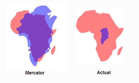
(58,618 posts)which make Greenland appear way larger than it actually is.
 :large

Stuart G
(38,414 posts)Very, very, and very cold. Thank You for showing us why we all get the size of Greenland wrong.
Wounded Bear
(58,618 posts)but anyway, apparently Mr Ericcson called it Greenland as a marketing ploy to get people to go there worthy of our esteemed Press-ident.

Response to Wounded Bear (Reply #4)
John Fante This message was self-deleted by its author.

tblue37
(65,269 posts)
backscatter712
(26,355 posts)Of course, you use different maps for different jobs, because it's impossible to render Earth's curved surface onto a flat paper or screen without distorting it.
Wounded Bear
(58,618 posts)Early sailors could measure latitude fairly easier with a sextant, but until the invention of an accurate clock that would work on a pitching ship at sea, longitude was at best an educated guess. Navigation back in the day was almost a case of "sail north or south to the proper latitude then sail east or west til you get close enough to the coast to spot some landmarks." Not quite that bad, but close.

Yonnie3
(17,427 posts)from https://www.monticello.org/thomas-jefferson/louisiana-lewis-clark/the-louisiana-purchase/

TheCowsCameHome
(40,168 posts)but not by much.

Mosby
(16,295 posts)
SeattleVet
(5,477 posts)it would make Texas the THIRD largest state!

kairos12
(12,849 posts)depicted the entire world from the perspective of Antartica. Mind blowing.
Ghost Dog
(16,881 posts)

IcyPeas
(21,855 posts)