General Discussion
Related: Editorials & Other Articles, Issue Forums, Alliance Forums, Region ForumsNOAA 5.00pm update - 185mph moving at 5mph, pressure 910mb
still due West
https://www.nhc.noaa.gov/storm_graphics/AT05/refresh/AL052019_5day_cone_no_line_and_wind+png/220614_5day_cone_no_line_and_wind.png
...EYE OF CATASTROPHIC HURRICANE DORIAN CRAWLING OVER THE ABACOS
ISLANDS IN THE BAHAMAS...
...DORIAN'S FURY NOW AIMING TOWARD GRAND BAHAMA...
SUMMARY OF 500 PM EDT...2100 UTC...INFORMATION
----------------------------------------------
LOCATION...26.6N 77.3W
ABOUT 95 MI...150 KM E OF FREEPORT GRAND BAHAMA ISLAND
ABOUT 175 MI...280 KM E OF WEST PALM BEACH FLORIDA
MAXIMUM SUSTAINED WINDS...185 MPH...295 KM/H
PRESENT MOVEMENT...W OR 270 DEGREES AT 5 MPH...7 KM/H
MINIMUM CENTRAL PRESSURE...910 MB...26.88 INCHES
WATCHES AND WARNINGS
--------------------
CHANGES WITH THIS ADVISORY:
A Storm Surge Warning has been issued from Lantana to the
Volusia/Brevard County Line.
A Storm Surge Watch has been issued from the Volusia/Brevard County
Line to the Flagler/Volusia County Line.
A Hurricane Warning has been issued from Jupiter Inlet to the
Volusia/Brevard County Line.
A Hurricane Watch has been issued from the Volusia/Brevard County
Line to the Flagler/Volusia County Line
SUMMARY OF WATCHES AND WARNINGS IN EFFECT:
A Storm Surge Warning is in effect for...
* Lantana to the Volusia/Brevard County Line
A Storm Surge Watch is in effect for...
* North of Deerfield Beach to Lantana
* Volusia/Brevard County Line to the Flagler/Volusia County Line
A Hurricane Warning is in effect for...
* Northwestern Bahamas excluding Andros Island
* Jupiter Inlet to the Volusia/Brevard County Line
A Hurricane Watch is in effect for...
* Andros Island
* North of Deerfield Beach to Jupiter Inlet
* Volusia/Brevard County Line to the Flagler/Volusia County Line
A Tropical Storm Warning is in effect for...
* North of Deerfield Beach to Jupiter Inlet
A Tropical Storm Watch is in effect for...
* North of Golden Beach to Deerfield Beach
* Lake Okeechobee
 = new reply since forum marked as read
Highlight:
NoneDon't highlight anything
5 newestHighlight 5 most recent replies
= new reply since forum marked as read
Highlight:
NoneDon't highlight anything
5 newestHighlight 5 most recent replies

triron
(21,990 posts)
mcar
(42,288 posts)Palm Beach, Jacksonville, for starters.
VMA131Marine
(4,137 posts)🤯🤯🤯🤯
love_katz
(2,578 posts)Forecast Discussion checked a short while ago. NHC mentioned an eye wall replacement cycle, and slight weakening due to interaction with the islands terrain. They did state that the Dorian may strengthen  due to low wind shear and warm ocean water. I will keep hopes up for all in its path that the storm weakens, or better yet, recurves out to sea. In the mean time, hopefully everyone affected is getting prepared, and paying close attention to the weather forecast. 225 mph gusts...just horrendous.
jberryhill
(62,444 posts)
malaise
(268,846 posts)This is the big one

BigmanPigman
(51,582 posts)malaise
(268,846 posts)and so will Coastal USA. I only hope some of those climate change deniers go down with the storm surges and building collapses.
BigmanPigman
(51,582 posts)I am all for that! Same applies with gun lovers.
jberryhill
(62,444 posts)Wow.
Reminds me of Ivan.
We escaped - Ivan did serious coastal damage but we didn't get a direct hit. Grenada and Cayman now - I'll never forget that one.

groundloop
(11,517 posts)When we visited the Bahamas a couple of years ago, there was still much evidence of damage done by Hurricane Matthew (which, as I recall, was Cat. 3 when it hit). Dorian will be far, far worse.
malaise
(268,846 posts)We can't repair the damage - we don't have the money so those who continue to deny that climate change in a factor are fucking up the entire planet. Did you see how fast this storm grew from Cat 1 to Cat 5

Sogo
(4,986 posts)Storms that start south of Barbados often reach our neighborhood - Gilbert, Ivan and many others.
OneBlueDotBama
(1,384 posts)Gov. Henry McMaster ordered mandatory evacuation of 830,000 people along the entire South Carolina coast starting noon Monday, days before powerful Hurricane Dorian is forecast to rake near the state.
Counties included in the evacuation order are all or portions of Charleston, Berkeley, Dorchester, Beaufort, Colleton, Jasper, Georgetown and Horry.
The state will reverse lanes on Interstate 26 from Charleston to Columbia and on U.S. 278 from Hilton Head Island starting at noon Monday. Traffic is expected to be heavy Monday, which is the end of the Labor Day holiday weekend.
Schools and government offices will be closed Tuesday in the eight coastal counties under the evacuation orders. About 200 coastal hospitals and nursing homes in those counties will be evacuated. Shelters will open Monday as evacuations start.
https://www.postandcourier.com/hurricanewire/dorian-evacuations-ordered-for-sc-coast-as-powerful-storm-approaches/article_7e3bb37e-cc25-11e9-95b8-d735532df817.html
malaise
(268,846 posts)for the Labor Day weekend

Scurrilous
(38,687 posts) 
Lochloosa
(16,061 posts)Predicted path it spared Jacksonville FL the worst.
This things moves 40 miles west of it's predicted path and all bets are off.
malaise
(268,846 posts)This is the big one

Pacifist Patriot
(24,653 posts)I live in Melbourne. Was over in Tampa for Matthew (already over there for a soccer tournament). Went to bed expecting to hear I didn't have a home when I woke up the next morning.
Neighbors who stayed called me at 6:30 a.m. to give me the good news.
"Wobbles" of just tens of miles can make a huge difference.

jpak
(41,757 posts)7:00 PM EDT Sun Sep 1
Location: 26.6°N 77.6°W
Moving: W at 5 mph
Min pressure: 910 mb
Max sustained: 185 mph
malaise
(268,846 posts)This is going right through Freeport and then heading for the mainland.
I don't want to think of the next 30 hours in Grand Bahama island because Dorian will be moving very slowly and destroying everything in its way.
jpak
(41,757 posts)Last edited Sun Sep 1, 2019, 08:48 PM - Edit history (1)
That is the day to watch.....
roamer65
(36,745 posts)The storms will be utter hell and people will be about 20 pct dumber due to CO2 cognitive impairment.

Ilsa
(61,691 posts)NickB79
(19,233 posts)Where some models predict we'll be by 2100.
Iwasthere
(3,158 posts)Said the wind speeds were so high they assumed something was wrong. So they tested speeds using old school methods, dropping devices... he said those tests showed just a couple mph below 200 mph. YIKES!
malaise
(268,846 posts)We didn't see this one coming with this intensity

BumRushDaShow
(128,717 posts)When the Hurricane Hunters (both NOAA and Air Force) go in to do recon missions, they normally "drop devices" (dropsondes). They have instruments on them to measure various conditions including temp, humidity (dew point), pressure, wind speed, etc. The raw data is then transmitted back and is available for ingestion into data models, etc.
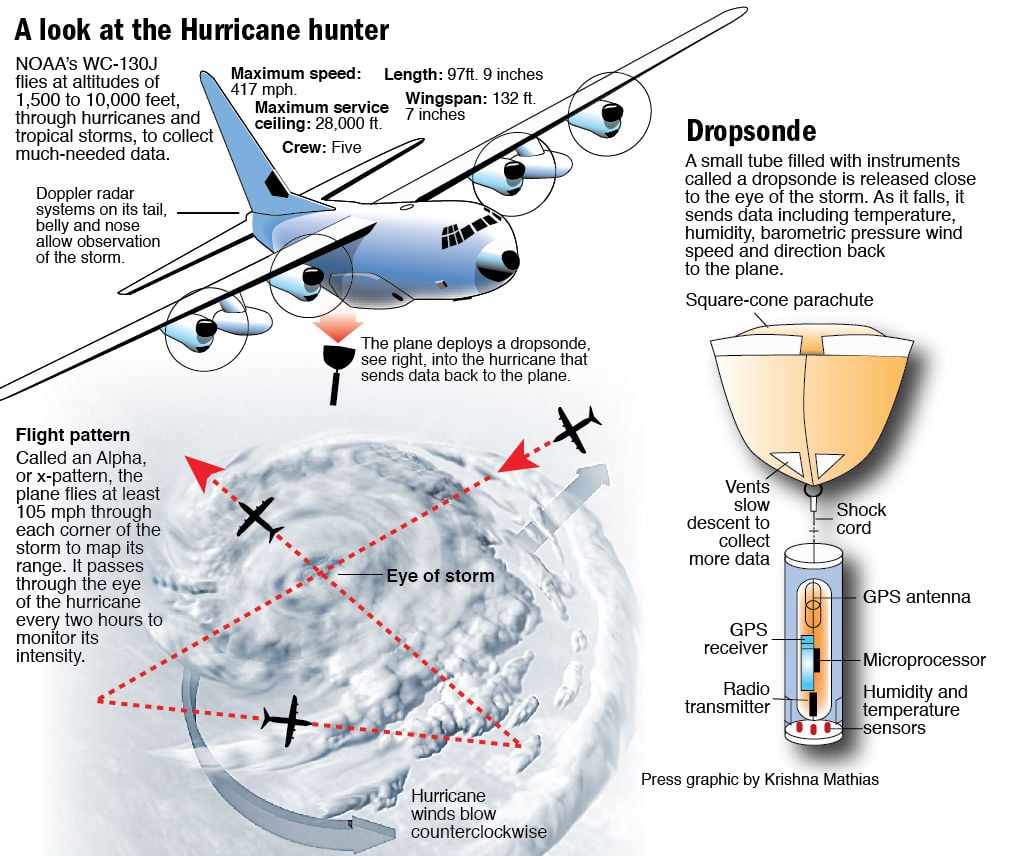
The problem is that for intense storms like this, oftentimes the excessive rain at a drop location might skew the wind speed data so they usually end up having to "flag" the reading and try again in other passes to verify the result.
You can track the missions at various places (I use this) - https://www.tropicaltidbits.com/recon/
NOAA's page - https://www.nhc.noaa.gov/recon.php

superpatriotman
(6,247 posts)AnnieBW
(10,421 posts)We visited the Abaco Islands on a cruise about 30 years ago (it was before we got married). A beautiful tropical paradise. Lots of American expats living there. I'm afraid that it won't be there anymore.

Iliyah
(25,111 posts)than coming west. Am I missing something?

LeftInTX
(25,202 posts)
We don't know if and when it will move north. (It will move north in the next several days, but if it doesn't move soon enough it will have major impact on South Florida. Once if moves north, it will move more rapidly and will begin to weaken, but until then it will be intensification mode. It will also be parked on the warm Gulf Stream, which will just make things worse.
It has been crawling west for about 24 hours now.
Baclava
(12,047 posts)