General Discussion
Related: Editorials & Other Articles, Issue Forums, Alliance Forums, Region Forums = new reply since forum marked as read
Highlight:
NoneDon't highlight anything
5 newestHighlight 5 most recent replies
= new reply since forum marked as read
Highlight:
NoneDon't highlight anything
5 newestHighlight 5 most recent replies

msongs
(67,395 posts)
Cheezoholic
(2,016 posts)The NHC doesnt check movement with a cursor. Hurricanes wobble, especially strong ones. The overall motion is right along the NHC's track. This is a very dangerous situation, this storm is stronger than Katrina and will be stronger than Katrina at landfall. You checked it with your cursor. Get real man.

zuul
(14,624 posts)that the location of the center of the eye can be deceiving. He said that he has to use multiple sources to find the true eye. It can be difficult to place with just one type of imagery.


littlemissmartypants
(22,632 posts)
applegrove
(118,622 posts) 
Demovictory9
(32,449 posts)samplegirl
(11,476 posts)
Response to jpak (Original post)
Throck This message was self-deleted by its author.

BumRushDaShow
(128,860 posts)but might not get there before landfall. Looks like there is a ragged eye there.
 v
v

Moebym
(989 posts)For those who don't know, it's the "Eyewall Replacement Cycle", which is basically the phenomenon wherein a powerful hurricane forms another eye around the previous one and eventually replaces it. The hurricane weakens during this process, but once the new eye replaces the old one, the storm re-strengthens.
https://www.theweatherprediction.com/habyhints2/412/
BumRushDaShow
(128,860 posts)
This is a hobby of mine for over 50 years so...

What tends to happen with the stronger storms (if they have enough time to do it before hitting land somewhere on their path) is that as the pressure deepens and the convection around the central core starts wrapping around what is attempting to be or is a small eye, if the convection that is wrapping around closes off (and it normally does that in a wider radius than the eye), then the center starts to collapse (and weaken) as the circulation attempts to re-establish itself closer to the wider convective circulation... And if that is successful, the center of what was the old eye starts clearing, and a new eye (usually a little wider) is formed.
You tend to see this more with storms that are coming from a distance (i.e., to this hemisphere across the Atlantic) where they have enough time to intensify before encountering land. In that case, they can even go through a couple ERCs before a landfall.

malaise
(268,936 posts)
wnylib
(21,432 posts)zuul
(14,624 posts)ashredux
(2,604 posts)Radar? It’s not real !

spinbaby
(15,088 posts)Which is definitely not a good sign.

jpak
(41,757 posts)Just now on CNN
malaise
(268,936 posts)Let that sink in!
The airport is more crowded than the one in Afghanistan and those are the people with means. This is going to be a catastrophe.
maryellen99
(3,788 posts)A lot of them were refusing to evacuate. Whole neighborhoods were staying.
Moebym
(989 posts)BumRushDaShow
(128,860 posts)Link to tweet
TEXT
@NWSWPC
⚠️Heavy rain from Ida has begun to impact the southeast LA coast this morning, with precipitation expanding across southeast LA and coastal/southern MS today into tonight (storm total: 10-18", iso. 24" ) resulting in life-threatening flash flooding and significant river flooding.
Image
Image
Image
Image
6:00 AM · Aug 29, 2021


(the above also as a note for those who may have been impacted by the flooding south of Nashville
 )
)
Link to tweet
TEXT
@NHC_Atlantic
·
Aug 29, 2021
Life-threatening storm surge inundation is expected today along portions of the coasts of Louisiana, Mississippi, and Alabama, and could reach 9 feet or greater above ground level somewhere within the area from Burns Point, Louisiana, to Ocean Springs, Mississippi #Ida
Image
National Hurricane Center
@NHC_Atlantic
Inundation could reach 12 to 16 feet above ground level from Port Fourchon, Louisiana, to the Mouth of the Mississippi River. This is a life-threatening situation! Everyone in the Storm Surge Warning area should follow the advice given by local officials http://hurricanes.gov
Image
6:29 AM · Aug 29, 2021

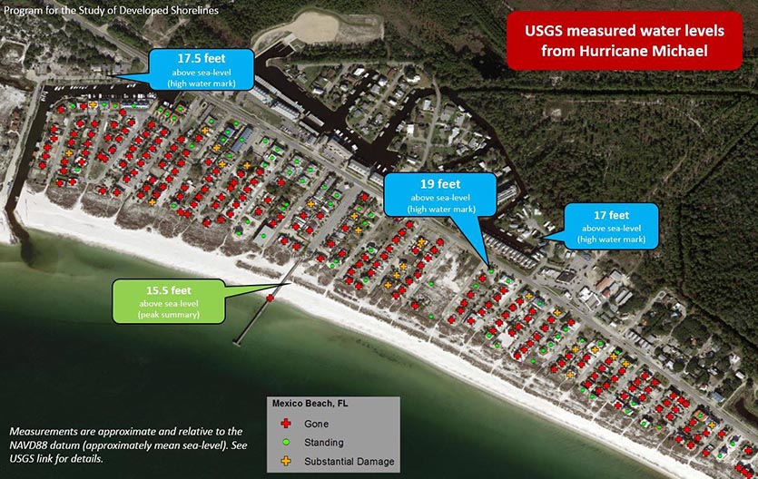
That potential of surge is akin to what happened in 2018 with Hurricane Michael's (as a Cat 5) landfall in Mexico Beach, FL - https://www.wtvy.com/2021/04/18/hurricane-micahel-storm-surge-catastrophic-for-mexico-beach/
Link to tweet
TEXT
@NHC_Atlantic
5 AM CDT August 29 -- Hurricane #Ida is still intensifying, with the most recent data from the @NOAA_HurrHunter aircraft indicating maximum sustained winds are up to 145 mph.
Latest Info: http://hurricanes.gov
Image
Image
6:01 AM · Aug 29, 2021

Irish_Dem
(46,924 posts)This is not looking good.
NickB79
(19,233 posts)Gonna hit New Orleans dead on. Holy shit.