Welcome to DU!
The truly grassroots left-of-center political community where regular people, not algorithms, drive the discussions and set the standards.
Join the community:
Create a free account
Support DU (and get rid of ads!):
Become a Star Member
Latest Breaking News
General Discussion
The DU Lounge
All Forums
Issue Forums
Culture Forums
Alliance Forums
Region Forums
Support Forums
Help & Search
General Discussion
Related: Editorials & Other Articles, Issue Forums, Alliance Forums, Region ForumsNASA Releases High Definition Image Of Earth (PHOTO)
I don't know about you but Earth is looking a little parched to me. 
InfoView thread info, including edit history
TrashPut this thread in your Trash Can (My DU » Trash Can)
BookmarkAdd this thread to your Bookmarks (My DU » Bookmarks)
6 replies, 1375 views
ShareGet links to this post and/or share on social media
AlertAlert this post for a rule violation
PowersThere are no powers you can use on this post
EditCannot edit other people's posts
ReplyReply to this post
EditCannot edit other people's posts
Rec (3)
ReplyReply to this post
6 replies
 = new reply since forum marked as read
Highlight:
NoneDon't highlight anything
5 newestHighlight 5 most recent replies
= new reply since forum marked as read
Highlight:
NoneDon't highlight anything
5 newestHighlight 5 most recent replies
= new reply since forum marked as read
Highlight:
NoneDon't highlight anything
5 newestHighlight 5 most recent replies
NASA Releases High Definition Image Of Earth (PHOTO) (Original Post)
Shankapotomus
Jan 2012
OP

Major Nikon
(36,827 posts)1. I can see my house
baldguy
(36,649 posts)5. I can see your house, too.
When did you get that pool?
Major Nikon
(36,827 posts)6. From all the rain we've had over the last few days
RC
(25,592 posts)2. Linky?

salvorhardin
(9,995 posts)3. The full size image is astounding
Blue Marble
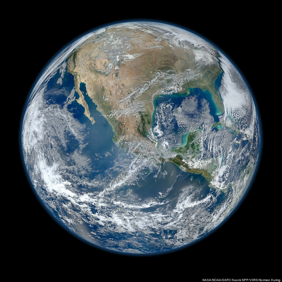
A 'Blue Marble' image of the Earth taken from the VIIRS instrument aboard NASA's most recently launched Earth-observing satellite - Suomi NPP. This composite image uses a number of swaths of the Earth's surface taken on January 4, 2012. The NPP satellite was renamed 'Suomi NPP' on January 24, 2012 to honor the late Verner E. Suomi of the University of Wisconsin.
Suomi NPP is NASA's next Earth-observing research satellite. It is the first of a new generation of satellites that will observe many facets of our changing Earth.
Suomi NPP is carrying five instruments on board. The biggest and most important instrument is The Visible/Infrared Imager Radiometer Suite or VIIRS.
Image Credit: NASA/NOAA/GSFC/Suomi NPP/VIIRS/Norman Kuring
http://www.nasa.gov/multimedia/imagegallery/image_feature_2159.html
Full size image can be found at the link.
Liberal_in_LA
(44,397 posts)4. lovely. going to make it my background for a while