General Discussion
Related: Editorials & Other Articles, Issue Forums, Alliance Forums, Region Forums(Holy shit) Incredible North Atlantic Storm Spans Atlantic Ocean From US to Europe

Incredible North Atlantic Storm Spans Atlantic Ocean, Coast to Coast
By Jason Samenow
The Washington Post
I’m not sure I’ve ever seen a storm this big before.
The storm shown here stretches west to east from Newfoundland to Portugal. Its southern tail (cold front) extends into the Caribbean and the north side of its comma head touches southern Greenland.
Not only is it big, but it’s also super intense – comparable to many category 3 hurricanes. The storm’s central pressure, as analyzed by the Ocean Prediction Center, is 953 mb. Estimated peak wave heights are around 25-30 feet.
The rest: http://www.washingtonpost.com/blogs/capital-weather-gang/wp/2013/03/28/incredible-storm-spans-atlantic-ocean-coast-to-coast/?tid=pm_pop
Learn to swim.
 = new reply since forum marked as read
Highlight:
NoneDon't highlight anything
5 newestHighlight 5 most recent replies
= new reply since forum marked as read
Highlight:
NoneDon't highlight anything
5 newestHighlight 5 most recent replies

RKP5637
(67,078 posts)
ewagner
(18,964 posts)That's affecting a lot of people on this tiny blue dot....

leveymg
(36,418 posts)AverageJoe90
(10,745 posts)
Hissyspit
(45,788 posts)AverageJoe90
(10,745 posts)
leveymg
(36,418 posts)lunatica
(53,410 posts)The way I see it we've done practically zilch about mitigating the problem of what we dump into the atmosphere and therefore we keep doing it. There won't be a new normal, other than weather that gets more and more intense as time goes on. The problem is that even if this isn't something we will see all the time NOW, it will be at some point in the future because the causes that intensified climate activity are not being addressed.
Theoretically we could not only see these kinds of storms as normal some day, but the weather will, in fact get even worse. Hopefully we can do something to stop that progression at some point before our planet turns into something like Venus.
AverageJoe90
(10,745 posts)*Sigh*. And frankly, I'm not sure how repeating the "Venus Syndrome" theory is helping people wake up, either. in fact, all stuff like that has done, is caused people to stick their heads in the sand, on top of being unprovable. 
lunatica
(53,410 posts)What do you think will happen when all the frozen and trapped methane is in the atmosphere? It's a good bet that what the worse thing that could happen will happen.
You don't have any more of a clue than the rest of us.
AverageJoe90
(10,745 posts)There plenty of reasons why this could not happen on Earth as we know it(at least not with global warming)?
1.)Firstly, Venus's atmosphere is approximately 96% carbon dioxide. Earth's, by comparison, is about .03% percent....that's a difference of many thousands of times' magnitude.
2.)Part of the reason for this, is because of volcanism that is many, many times greater than on Earth, and a far weaker carbon cycle.
3.)Also, look at the paleoclimate data. Even when Earth became some 12*C+ warmer than it is today during the Paleocene era, no runaway warming took place, nor at the end of the last Ice Age, when temperatures jumped 10*C in just a century(something that won't be repeated today, due to special conditions at the time). That alone, should tell you something.
I'll admit I'm not exactly talented when it comes to explanations of things, usually, unless I have loads of material in front of me, and I'm sorry if it's not to your satisfaction, but these are all important things to keep in mind.
muriel_volestrangler
(101,257 posts)(I assume it didn't get the record, because I can only find this WP article saying it 'threatens' the record in a forecast).
http://www.washingtonpost.com/blogs/capital-weather-gang/wp/2013/03/21/record-blocking-patterns-fueling-extreme-washington-d-c-march-weather/

lapislzi
(5,762 posts)How does that affect world weather in the short and long term? Not being snarky; I really don't know much about global meteorology.
Edited to add: I can't know everything! Too much pressure (see what I did there) for this Jeopardy champion #humblebrag
muriel_volestrangler
(101,257 posts)It may have meant a particularly large area of stable weather over the north Atlantic; it may have meant stronger winds in some are between it and a neighbouring low pressure area. It may not have meant much at all, short or long term. But it is a measurement used in meteorology, and that an all-time world record was nearly broken, in an area of particular interest (because of melting ice), seems worth noting, in passing at least.
southernyankeebelle
(11,304 posts)clouds and more clouds. Looks like marshmallows to me. I don't understand any of it.

tavalon
(27,985 posts)A swirl of that magnitude means very strong winds - hurricane force and pretty organized. I've also never seen a "hurricane" that big before. I would hope that would mean the power is dispersed more lightly throughout, but I think it's probably the opposite.

Sunlei
(22,651 posts)muriel_volestrangler
(101,257 posts)See http://nsidc.org/data/atlas/news/bedrock_elevation.html . However, that's with a couple of kilometres of ice above it, pressing down; if the ice melted, there would be isostatic rebound, which would be enough to get that central depression back above sea level.
Actually, if you look at the NSIDC page, you'll see 'a cluster of islands' is a good description of West Antarctica (anything grey in the picture is bedrock below sea level). If it all melted, it's quite possible that the land on the left of that picture - which is the Antarctic Peninsula (which points towards South America) and West Antarctica (south of the Pacific) would be cut off from the larger landmass of East Antarctica.
Sunlei
(22,651 posts)population lives so close to the major runoff areas.

jollyreaper2112
(1,941 posts)Can't find any. What are they calling it?
Katashi_itto
(10,175 posts)
dixiegrrrrl
(60,010 posts)Which is still a dumb idea.....
NPR covering it...
http://www.npr.org/blogs/thetwo-way/2013/03/29/175675125/top-stories-huge-atlantic-storm-ncaa-basketball-upsets-harry-potter-actor-dies
caraher
(6,278 posts)Those names are not official, they're a Weather Channel gimmick. Only hurricanes/tropical storms etc. get names that have any generally-recognized standing
MindPilot
(12,693 posts)The only source seems to be this WaPo blog. Me thinks 'tis BS.

unapatriciated
(5,390 posts)muriel_volestrangler
(101,257 posts)It would be far bigger news than anything else in this thread. And it's not the same, as we can see by examining some weather in February:
On the afternoon of February 9, as the storm was departing New England and moving toward Nova Scotia, the structure of the extratropical storm on satellite imagery resembled that of a tropical cyclone with a well-defined eye-like feature while located east of Cape Cod.[34]
The cyclonic eye dissipated on the morning of February 10, while the nor'easter was moving out to sea. Later, the nor'easter passed just south of Greenland. During the next several days, the system continued moving eastwards toward the British Isles while weakening, and eventually left the GOES-East satellite covered region. The nor'easter reorganized while it was south of Iceland, and affected the UK and the Republic of Ireland from February 15 to 18.[35] After affecting the UK, the storm became indistinguishable, while turning northeastwards. Late on February 20, the remnants of the February 2013 Nor'easter were absorbed by a more powerful extratropical cyclone to the north.
http://en.wikipedia.org/wiki/February_2013_nor%27easter
North Atlantic weather systems generally cross it from west to east in a couple of weeks, while drifting north, like that one. The one from late January will not the one there now.

tosh
(4,422 posts)
Tommy_Carcetti
(43,128 posts)
MNBrewer
(8,462 posts)jollyreaper2112
(1,941 posts)Only tropical cyclones are named in the Atlantic and Pacific. The Weather Channel started naming winter storms. There's no official policy to name something like this.
The question is whether it will make landfall. Sort of like the Russian meteor, it's so significant only because it occurred over a populated area. While science buffs would be just as happy to know about it impacting in the middle of the ocean, the average person wouldn't know or care. If this storm blows itself out far to sea, nobody but the scientists will have paid attention.
olddots
(10,237 posts)guess nature and science are too high brow for MSM news

malaise
(268,559 posts)We've had some serious rain in the North-East - at least one bridge collapsed and people were stranded overnight
UnrepentantLiberal
(11,700 posts)malaise
(268,559 posts)Jamaica 
UnrepentantLiberal
(11,700 posts)

In_The_Wind
(72,300 posts)
Botany
(70,422 posts).... water is changing the planet's weather to a new normal.
Hurricane Sandy, the early spring blizzards and serve cold in the midwest and the east,
and now this super storm.
http://www.democraticunderground.com/1014434657

subterranean
(3,427 posts)I don't see where it reaches the U.S., unless you count Guantanamo. Nevertheless, an impressive storm! Even scarier are those giant spikes protruding into the Atlantic and North Africa!!

Myrina
(12,296 posts)


ReRe
(10,597 posts)Last edited Fri Mar 29, 2013, 12:02 PM - Edit history (1)
...they were in the middle of a discussion about CLIMATE CHANGE. Commercials now. (11:15am EST). Will hold until the damn commercials have run their course and see if TWC tells about this. I have TWC on this computer, but will have to reboot to get it back up.
It's 11:25am now. Going to reboot and see what I can see on TWC radar...
Edit at Noon, EST: I can't see a thing on my TWC radar. Still haven't heard anything on TV weather channel.
Rosa Luxemburg
(28,627 posts)I wonder will they cancel the flight?

BumRushDaShow
(128,257 posts)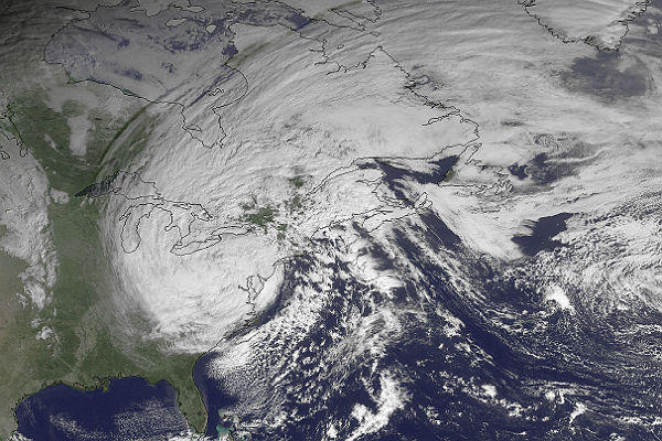
And it had a pressure as low as 940 mb.
onenote
(42,499 posts)To quote from Jason Samenow's report on the storm:
"The storm is forecast to remain more or less stationary over the next few days before substantially weakening and then eventually drifting into western Europe in about a week as a rather ordinary weather system."
AverageJoe90
(10,745 posts)
onenote
(42,499 posts)My point simply made in response to those that are wondering why the media is covering this as a big story. Its because its not a particularly big story in terms of its impact here in the US or even overseas. And making it out to be a big story would only create confusion.
nadinbrzezinski
(154,021 posts)
David Zephyr
(22,785 posts)Good grief, William. I had no idea. Please keep this old guy posted.

undeterred
(34,658 posts)And his fishing boat went down?
Sunlei
(22,651 posts)wonder how warm the sea has to get to generate 100 foot waves? another 2 or 3 degrees?

hunter
(38,299 posts)Living under a year-round hurricane would suck.

http://en.wikipedia.org/wiki/Atmosphere_of_Jupiter
AverageJoe90
(10,745 posts) 
winter is coming
(11,785 posts)Bolo Boffin
(23,796 posts)I'd always heard the warmer the water, the more energy available to the storms building on top of them.
But Al Gore is so very fat...

MzShellG
(1,047 posts)
