General Discussion
Related: Editorials & Other Articles, Issue Forums, Alliance Forums, Region ForumsThe real size of the African Continent
http://www.whydontyoutrythis.com/2013/04/the-true-size-of-africa-erroneous-map.html
Although featured in 'The West Wing', this map dishonesty is anything but fictional. The video below will give you an accurate look at the size of Africa.
People are often not aware of how large Africa continent really is. The image below is an accurate look at Africa relative to some major countries:
http://1.bp.blogspot.com/-ClfIgQoIvL0/UWLleT93YoI/AAAAAAAADto/-Xle6X_dZd8/s1600/The+true+size+of+Africa+%E2%80%93+it%E2%80%99s+bigger+than+you+think.gif
Why do they think they all want a piece
 = new reply since forum marked as read
Highlight:
NoneDon't highlight anything
5 newestHighlight 5 most recent replies
= new reply since forum marked as read
Highlight:
NoneDon't highlight anything
5 newestHighlight 5 most recent replies

leftstreet
(36,106 posts)Thanks for posting this

dipsydoodle
(42,239 posts)
truebrit71
(20,805 posts)...But it is interesting nonetheless...

Igel
(35,300 posts)Near the pole the lines of longitude grow closer together. As you approach the equator, the circumference of the Earth is greater and the lines of longitude are farther apart.
As soon as you stipulate that they must be equidistant at all latitudes you've stretched things. Britain's north of France; it's a bit wider than it should be compared to France.
truebrit71
(20,805 posts)...which was more my point...

Posteritatis
(18,807 posts)truebrit71
(20,805 posts)...it's still too small in this map 

Blue Owl
(50,349 posts) 
Baitball Blogger
(46,699 posts)awoke_in_2003
(34,582 posts)
Aristus
(66,316 posts)to the Peters Projection. The significant difference between the two inspired C.J to ask the cartographers: "What is that?!?
Their reply: "It's where you've been living this whole time."

RevStPatrick
(2,208 posts)Along with the episode with the fake Dr. Laura.
Aristus
(66,316 posts)"You may have mistaken this for your monthly meeting of the ignorant tight-ass club, but in this building, when the President stands, nobody sits!"
I've got that one from memory... 
RevStPatrick
(2,208 posts)I would vote for Jed Bartlett, MS or no MS...


progressoid
(49,978 posts)

malaise
(268,921 posts)

CrispyQ
(36,457 posts)
Great graphic!
krispos42
(49,445 posts)...cost me 2 hours on Wikipedia, studying cartography.

kentauros
(29,414 posts)except for maybe geo-political reasons. If you're trying to get to a certain point on the globe, then all you need are lat/long or Northing/Easting numbers.
It's all just 2D representations of the globe anyway. Thankfully, with GIS and Civil 3D, you can take your XYZ points and make a map in almost any projection, feet or meters. I have no personal preference for projections, just whatever the client likes best. They're the ones that matter the most
arcane1
(38,613 posts) 
PD Turk
(1,289 posts)

RevStPatrick
(2,208 posts)...Hobo-Dyer and Peirce Quincunial, but really I'm a Globe kind of guy.
CrispyQ
(36,457 posts)~kick.

Octafish
(55,745 posts)Then, he died. And his successor returned to business as usual, going back to 1953, when Allen Dulles' CIA joined the European colonial powers to carve up something worth stealing. From then to the present day, there was one, brief, 34-month respite:
JFK Cried for Congo
EXCERPT...
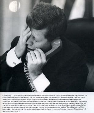
The above caption, by Jacques Lowe, personal photographer to JFK, reads:
"On February 13 1961, United Nations Ambassador Adlai Stevenson came on the phone. I was alone with the President; his hand went to his head in utter despair, "On, no," I heard him groan. The Ambassador was informing the President of the assassination of Patrice Lumumba of the Congo, an African leader considered a trouble-maker and a leftist by many Americans. But Kennedy's attitude towards black Africa was that many who were considered leftists were in fact nationalists and patriots, anti-West because of years of colonialization, and lured to the siren call of Communism against their will. He felt that Africa presented an opportunity for the West, and, speaking as an American, unhindered by a colonial heritage, he had made friends in Africa and would succeed in gaining the trust of a great many African leaders. The call therefore left him heartbroken, for he knew that the murder would be a prelude to chaos in the mineral-rich and important African country, it was a poignant moment."
Dodd and Dulles vs. Kennedy in Africa
“In assessing the central character ...
Gibbon’s description of the Byzantine general
Belisarius may suggest a comparison:
‘His imperfections flowed from the contagion of the times;
his virtues were his own.’”
— Richard Mahoney on President Kennedy
By Jim DiEugenio
CTKA From the January-February 1999 issue (Vol. 6 No. 2)
As Probe has noted elsewhere (especially in last year’s discussion of Sy Hersh’s anti-Kennedy screed, The Dark Side of Camelot), a clear strategy of those who wish to smother any search for the truth about President Kennedy’s assassination is to distort and deny his achievements in office. Hersh and his ilk have toiled to distort who Kennedy really was, where he was going, what the world would have been like if he had lived, and who and what he represented. As with the assassination, the goal of these people is to distort, exaggerate, and sometimes just outright fabricate in order to obfuscate specific Kennedy tactics, strategies, and outcomes.
This blackening of the record—disguised as historical revisionism—has been practiced on the left, but it is especially prevalent on the right. Political spy and propagandist Lucianna Goldberg—such a prominent figure in the current Clinton sex scandal—was tutored early on by the godfather of the anti-Kennedy books, that triple-distilled rightwinger and CIA crony Victor Lasky. In fact, at the time of Kennedy’s death, Lasky’s negative biography of Kennedy was on the best-seller lists. Lately, Christopher Matthews seemed to be the designated hitter on some of these issues (see the article on page 26). Curiously, his detractors ignore Kennedy’s efforts in a part of the world far from America, where Kennedy’s character, who and what he stood for, and how the world may have been different had he lived are clearly revealed. But to understand what Kennedy was promoting in Africa, we must first explore his activities a decade earlier.
SNIP...
To say the least, this is not what the Dulles brothers John Foster and Allen had in mind. Once the French empire fell, they tried to urge upon Eisenhower an overt American intervention in the area. When Eisenhower said no, Allen Dulles sent in a massive CIA covert operation headed by Air Force officer Edward Lansdale. In other words, the French form of foreign domination was replaced by the American version.
SNIP...
1964: LBJ reverses Kennedy’s policies
In 1964, the leftist rebellion picked up strength and began taking whole provinces. President Johnson and National Security Adviser McGeorge Bundy decided that a weakened Adoula had to be strengthened with a show of American help. The CIA sent Cuban exile pilots to fly sorties against the rebels. When the UN finally withdrew, the US now became an ally of Belgium and intervened with arms, airplanes and advisors. Incredibly, as Jonathan Kwitny notes, Mobutu now invited Tshombe back into the Congo government (p. 79). Further, Tshombe now blamed the revolts on China! To quote Kwitny:
In a move suspiciously reminiscent of a standard US intelligence agency ploy, Tshombe produced what he said were some captured military documents, and a Chinese defector who announced that China was attempting to take over the Congo as part of a plot to conquer all of Africa. (p. 79)
With this, the Mobutu-Tshombe alliance now lost all semblance of a Gullion-Kennedy styled moderate coalition. Now, rightwing South Africans and Rhodesians were allowed to join the Congolese army in the war on the “Chinese-inspired left”. Further, as Kwitny also notes, this dramatic reversal was done under the auspices of the United States. The UN had now been dropped as a stabilizing, multilateral force. This meant, of course, that the tilt to the right would now go unabated. By 1965, the new American and Belgian supplemented force had put down the major part of the rebellion. General Mobutu then got rid of President Kasavubu. (Adoula had already been replaced by Tshombe.) In 1966, Mobutu installed himself as military dictator. The rest is a familiar story. Mobutu, like Suharto in Indonesia, allowed his country to be opened up to loads of outside investment. The riches of the Congo, like those of Indonesia, were mined by huge western corporations, whose owners and officers grew wealthy while Mobutu’s subjects were mired in abject poverty. As with the economy, Mobutu stifled political dissent as well. And, like Suharto, Mobutu grew into one of the richest men in the world. His holdings in Belgian real estate alone topped one hundred million dollars (Kwitny p. 87). Just one Swiss bank account was worth $143 million. And like Suharto, Mobutu fell after three decades of a corrupt dictatorship, leaving most of his citizenry in an anarchic, post-colonial state similar to where they had been at the beginning of his reign.
The policies before and after Kennedy’s in this tale help explain much about the chaos and confusion going on in Congo today. It’s a story you won’t read in many papers or see on television. In itself, the events which occurred there from 1959 to 1966 form a milestone. As Kwitny writes:
The democratic experiment had no example in Africa, and badly needed one. So perhaps the sorriest, and the most unnecessary, blight on the record of this new era, is that the precedent for it all, the very first coup in post-colonial African history, the very first political assassination, and the very first junking of a legally constituted democratic system, all took place in a major country, and were all instigated by the United States of America. (p. 75)
CONTINUED...
http://www.ctka.net/pr199-africa.html
Like in Vietnam, policy toward Congo and the rest of Africa did a 180. Who knew all our diamonds, gold and oil would be under their dirt? Heh heh heh.
malaise
(268,921 posts)Maybe this is the angle to investigate Kennedy's assassination?
http://www.theguardian.com/global-development/poverty-matters/2011/jan/17/patrice-lumumba-50th-anniversary-assassination
<snip>
With the outbreak of the cold war, it was inevitable that the US and its western allies would not be prepared to let Africans have effective control over strategic raw materials, lest these fall in the hands of their enemies in the Soviet camp. It is in this regard that Patrice Lumumba's determination to achieve genuine independence and to have full control over Congo's resources in order to utilise them to improve the living conditions of our people was perceived as a threat to western interests. To fight him, the US and Belgium used all the tools and resources at their disposal, including the United Nations secretariat, under Dag Hammarskjöld and Ralph Bunche, to buy the support of Lumumba's Congolese rivals , and hired killers.
In Congo, Lumumba's assassination is rightly viewed as the country's original sin. Coming less than seven months after independence (on 30 June, 1960), it was a stumbling block to the ideals of national unity, economic independence and pan-African solidarity that Lumumba had championed, as well as a shattering blow to the hopes of millions of Congolese for freedom and material prosperity.
The assassination took place at a time when the country had fallen under four separate governments: the central government in Kinshasa (then Léopoldville); a rival central government by Lumumba's followers in Kisangani (then Stanleyville); and the secessionist regimes in the mineral-rich provinces of Katanga and South Kasai. Since Lumumba's physical elimination had removed what the west saw as the major threat to their interests in the Congo, internationally-led efforts were undertaken to restore the authority of the moderate and pro-western regime in Kinshasa over the entire country. These resulted in ending the Lumumbist regime in Kisangani in August 1961, the secession of South Kasai in September 1962, and the Katanga secession in January 1963.
Octafish
(55,745 posts)Not all that odd to read how the CIA man made it to the top of the MIC heap.
"Carlucci" bleeped from HBO version of Lumumba
Ex-CIA official threatened lawsuit
By Joanne Laurier
15 March 2002
Home Box Office (HBO), the US cable television network, is currently broadcasting a censored version of Lumumba, the award-winning film about Patrice Lumumba, the first prime minister of independent Congo, assassinated by imperialist agents in January 1961.
Haitian-born director Raoul Peck’s work fictionally reconstructs Lumumba’s coming to power in 1960 and the intrigues which led to his brutal murder. The film shown on HBO is a version of the French-language original dubbed into English, which bleeps out the name of Frank Carlucci, a future deputy director of the Central Intelligence Agency (CIA) and secretary of defense, in the dialogue and masks his name in the credits. At the time of Lumumba’s death, Carlucci was the second secretary at the US embassy in the Congo and, covertly, a CIA agent.
This attempt to keep Carlucci’s role in the Congo from television audiences follows the release of US government documents revealing that President Dwight Eisenhower ordered the CIA to murder Lumumba. Minutes of an August 1960 National Security Council meeting confirm that Eisenhower told CIA chief Allen Dulles to “eliminate” the Congolese leader. The official note taker, Robert H. Johnson, testified to this before the Senate Intelligence Committee in 1975, but no documentary evidence had been previously available to back up his claim.
Carlucci’s lawyers threatened Peck and distribution company Zeitgeist Films with legal action if the name of the former US official was not bleeped out of a scene that shows American Ambassador Clare Timberlake and Carlucci, along with Belgian and Congolese officials, plotting Lumumba’s assassination. Carlucci insisted that only the altered version of the film, with his name missing, could be used for mass market venues, such as television, video and DVD, allowing the original track to remain intact for theater showings. Zeitgeist officials said they were too small and weak financially to fight a case in court.
Carlucci is an immensely wealthy individual, with connections at the highest levels of the US government. Deputy chief of the CIA under Jimmy Carter and secretary of defense under Ronald Reagan, Carlucci is now chairman of the Carlyle Group, a private equity investment group with billions of dollars of assets in the defense industry. The company employs prominent ex-officeholders, such as former president George Bush, former British prime minister John Major and former president of the Philippines Fidel Ramos. Carlucci has the closest financial, political and personal ties to the Bush family. Other figures involved in Carlyle Group operations include former secretary of state James Baker, who headed up George W. Bush’s effort to block vote recounts in Florida in 2000 and hijack the presidential election. Carlucci has a long-term political relationship with his former classmate and wrestling buddy from Princeton, the present secretary of defense, Donald Rumsfeld.
At a January 24 screening of the film in New York held at the Council on Foreign Relations (CRF), publisher of Foreign Affairs magazine, Peck confirmed that the film had been changed in response to Carlucci’s legal threats. Despite considerable media presence at the event, during which Washington Post columnist Richard Cohen, for one, raised a question about Carlucci’s name being removed, virtually nothing has appeared in the mainstream media about the issue.
The WSWS spoke with freelance journalist Lucy Komisar, who attended the screening and wrote an article about Carlucci’s action for the Pacific News Service. She commented: “This is censorship. This is a story that he [Carlucci] does not want to talk about. Although he was not in charge [of the CIA’s Congo activities in 1960], he was involved in what was going on. It is a part of his history. The honorable thing to do would have been to acknowledge that the Americans helped in doing away with a man who could have helped that region—that they supported Mobutu, who for decades led a brutal dictatorship which caused enormous suffering. I think the incident shows the extremes to which people like Carlucci will go to cover up actions they know were wrong—even to censoring a movie.”
CONTINUED...
http://www.wsws.org/en/articles/2002/03/carl-m15.html
CIA never told President-elect Kennedy they were planning to assassinate Lumumba. Perhaps they assumed a President-elect Nixon would've approved.
These are gangsters, at heart, malaise. Thieving, mass murdering, racist gangsters who shot their way into power in Dallas.
malaise
(268,921 posts)that he was murdered by the CIA.
7962
(11,841 posts)I dont get it. The 2 maps I have at home, and I just went and looked at them to be sure, show Africa WAY larger than the us and europe, and yes, even Greenland. And they've got quite a few years on them too. One of them I've had since high school and thats a lot older than I want to admit. I dont think I've ever seen a map like the one in the clip with Africa so tiny.
Yes, lets flip the world upside down on the map, that'll really help the students of today learn the continents better, wont it.
kentauros
(29,414 posts)so to speak. I have one of those flipped maps, had it for many years. It can be a challenge to find some of the tiny European countries, but you end up learning all the ones nearby first.
And if you think about it, if you're in a plane, flying from north to south, you're seeing the world "upside down"
7962
(11,841 posts)tabasco
(22,974 posts)Who knew?
Lee-Lee
(6,324 posts)Tells me she is very worried by the growing Chinese presence there- she fears they my try to de-facto colonize Africa and exploit the labor as the rising middle class in China makes exploiting cheap labor there more and more difficult.

dixiegrrrrl
(60,010 posts)BIG undeclared currency and resource wars going on in Africa.
Suddenly soe African countires are being destabilized, leaders being taken out one way or the other.
Destabilized countries are much much easier to control and exploit....Iraq being a perfect example/

pampango
(24,692 posts)over the past few decades. What if they don't? Is there a different development path for them?
malaise
(268,921 posts)were stolen to work for others as slaves.
Africa's people will survive. I hope they never go the manufacturing route and pollute that magnificent continent full of resources.
I see lots of people lining up to steal Africa's water and other resources these days.
pampango
(24,692 posts)They deserve it. A beautiful continent with more people than North America or Europe.

formercia
(18,479 posts)The Equatorial Climate will bring a whole new meaning to Sweat Shops.

Nye Bevan
(25,406 posts)It's a little presumptive to expect Africa to be an enormous exotic theme park for the enjoyment of European and American tourists.
Orrex
(63,200 posts)I see that one of the "popular" articles from that site is a cushy piece about the dangerous and pathological opportunist Andrew Wakefield.
Alas.
malaise
(268,921 posts) 
GreenStormCloud
(12,072 posts)Back then I learned that the Mercator projection was the ONLY projection that allowed one to draw a rhumb line on it. A rhumb line connects any two points with a straight line path that has the same true compass bearing at all points. It is next to impossible, without GPS & computers, to steer a great circle (shortest distance) route as the compass bearing is constantly changing. So the navigator will plot several points of the great circle route on a mercator projection, draw rhumb lines connecting the points, and then tell the pilot or helmsman to steer a particular compass heading until a certain time or place, the make a course change to the new heading. Such a course is a little bit longer, but much easier to steer.
For hundreds of years navigators demanded mercator maps, so they became the standard that everybody used.
That is why the Mercator projection became so popular.
When navigating in the arctic regions, the advantages of the mercator loose ground to the disadvantages and one has to switch to a different method.
malaise
(268,921 posts)Didn't have a clue about that.
Orrex
(63,200 posts)I've never studied cartography, but the particular value of Mercator that you cite never once came up in any of my geography courses or the like.
Thanks!
Nye Bevan
(25,406 posts)A globe is good to have.
PoliticAverse
(26,366 posts)
hunter
(38,310 posts)Even if it's a flat one you spin around in a web browser.

derby378
(30,252 posts)I'm more favorably inclined towards Robinson, Kavrayskiy VII, and maybe and Winkel tripel. There's always going to be an issue with mapping a sphere onto a flat plane, but these projections seem to be heading in the right direction.

loyalsister
(13,390 posts)The West Wing addressed some very valid points, but making the scenario humorous was a mistake.
malaise
(268,921 posts)Sometimes humor is the only way to elicit a serious discussion about a controversial subject
loyalsister
(13,390 posts)And very often true. But I didn't feel like the left much room for viewers to stop ad think in that scene.

TheMightyFavog
(13,770 posts)IIRC, the trip took them a little over about two years.
malaise
(268,921 posts)Damn!
PowerToThePeople
(9,610 posts)
mimi85
(1,805 posts)I don't think not putting Alaska or Australia or the poles are the point of the map. But hey, maybe I'm wrong.
Liberal_in_LA
(44,397 posts)
arely staircase
(12,482 posts)I am going to order some of these maps and put them up in my 4th grade classroom. When the kids ask about the difference between them and their social studies text books, I will explain that they are more accurate in showing land mass size and the others are a holdover from earlier times. I probably won't get into the cultural imperialism aspect of it (the grade level and area I live in prevent that.) But if I make the point the maps they see in books aren't accurate, some will make the connection when they are older.
malaise
(268,921 posts)Give us the feedback
Jim Lane
(11,175 posts)Two important bits of information from a map relate to a trip between any two points: the direction you go to get from A to B, and the distance.
It is mathematically impossible for a flat map to portray a spherical surface in a way that will be perfectly accurate as to both those questions.
I'm inclined to doubt that there was a decision based on "cultural imperialism" to use a map that made Africa seem smaller (and therefore, presumably, less important) than it appears on other maps. I mean, it's still pretty big on any of the maps. Furthermore, there was no rush to colonize Greenland just because Mercator made it look bigger than South America. It seems more likely that people just preferred a map that was better on getting the direction right, as explained by GreenStormCloud in #25.
Nye Bevan
(25,406 posts)who deliberately concocted a projection that made Africa look too small.

Recursion
(56,582 posts)Gall-Peters is actually "worse" by a lot of criteria.
http://xkcd.com/977/