General Discussion
Related: Editorials & Other Articles, Issue Forums, Alliance Forums, Region ForumsInto the mountains - not.
A friend just posted this on facebook -- this is Highway 34 headed west out of Loveland, Colorado; Big Thompson canyon, river of the same name came roaring down the canyon. This is the road we always take to Estes Park, and many parts of the highway have been washed out. Last report was that Highways 34, 36 and 7 are all impassable; the only way into or out of Estes Park is Trail Ridge Road.

 = new reply since forum marked as read
Highlight:
NoneDon't highlight anything
5 newestHighlight 5 most recent replies
= new reply since forum marked as read
Highlight:
NoneDon't highlight anything
5 newestHighlight 5 most recent replies

hlthe2b
(102,225 posts)I can only imagine what is upstream and due to descend soon...
Anyone who relishes a sense of history should google the Big Thompson Canyon Flood of 1976, Colorado's worst. A very similar situation is in progress now, there and elsewhere along the front range of Colorado--though I hope changes made since then will result in far less mortality and perhaps, less significant and long standing damage.

wandy
(3,539 posts)Now "welcome to the Island Republic(s) of Boulder. It's been fairly dry in the high desert and folk have been hoping for rain.
Be careful what you ask for, you may get it.
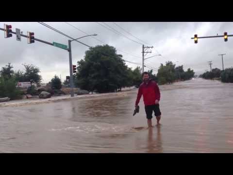
This is what the rout South West from my part of town looked like yesterday afternoon.

Theirs a road under there, somewhere.
Other routs didn't look any better.


Many comunites became islands.
This is unusual for this part of the world, with more rain predicted.

madamesilverspurs
(15,800 posts)Showing rescuers using zip-lines to retrieve stranded people in Estes Park.

likesmountains 52
(4,098 posts)madamesilverspurs
(15,800 posts)This is a pic of "The Narrows" portion of Hwy 34 in Big Thompson Canyon. Seventeen miles of this road have been destroyed so far.
