General Discussion
Related: Editorials & Other Articles, Issue Forums, Alliance Forums, Region ForumsThis map shows Americas real unemployment problem
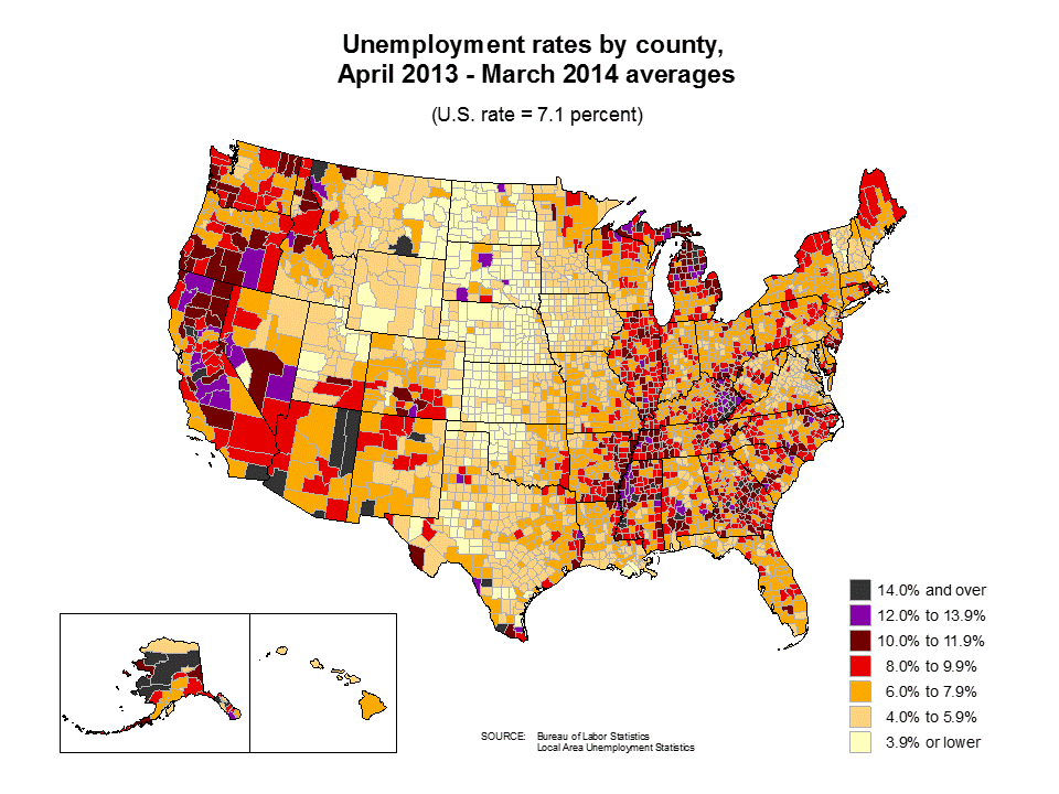
Every month, the Bureau of Labor Statistic releases their latest cut at the jobs data. And every month, we dutifully report the national unemployment rate, as if unemployment is a singular national phenomenon.
But it's not. America has one flag. But it doesn't have one unemployment rate, as this map from the BLS shows: Twmcort
What you're seeing there is average unemployment over the last year broken out by county. The differences between states and counties are tremendous. There are states in America that are enjoying genuinely good times. And then there are states with unemployment rates that, nationally, would be considered an emergency.
In Nebraska, for instance, the unemployment rate is 3.7 percent. That's lower than the national unemployment rate ever got during the roaring 90s.
http://www.vox.com/2014/5/2/5675238/this-map-shows-america-s-real-unemployment-problem
" "
"
 = new reply since forum marked as read
Highlight:
NoneDon't highlight anything
5 newestHighlight 5 most recent replies
= new reply since forum marked as read
Highlight:
NoneDon't highlight anything
5 newestHighlight 5 most recent replies

unblock
(52,196 posts)
TransitJohn
(6,932 posts)n/t
unblock
(52,196 posts)meanwhile, oceans are clearly job destroyers.
on edit, i'll add rivers. look at the mississippi. jobs clearly float downstream.

Wounded Bear
(58,647 posts)Low pop density in the heartland has low unemployment, in general.
Also, Central California is in severe drought conditions, leading to loss of jobs in the agriculture that permeates the area.
A lot of the purple and red counties are shackled by RW wing-nuttery at the state and local levels, as well. Seel Northern Michigan, Appalacian Kentucky and stretches of the deep South.