LATEST FORECAST: 90 PERCENT CHANCE OF CYCLONE FORMATION
Source: ABC 11 Eyewitness News
The National Weather service said there is an 80 percent chance of cyclone formation over the next 48 hours.
WRIGHTSVILLE BEACH, N.C. (WTVD) -- Parts of the North Carolina coast are already feeling the effects of a storm off the coast expected to develop into a subtropical or tropical storm as early as Friday.
An Air Force Reserve hurricane hunter aircraft traveled into the storm Thursday and came back with data that showed a "high" chance for a subtropical or tropical weather system hitting eastern North Carolina.
Central North Carolina, including Raleigh, may also see bands of heavy rain over the weekend as the storm makes its way inland.
Read more: http://abc11.com/weather/latest-forecast-90-percent-chance-of-cyclone-formation/699891/
 = new reply since forum marked as read
Highlight:
NoneDon't highlight anything
5 newestHighlight 5 most recent replies
= new reply since forum marked as read
Highlight:
NoneDon't highlight anything
5 newestHighlight 5 most recent replies

Chasstev365
(5,191 posts)Isn't a Cyclone only in the Pacific and a Hurricane in the Atlantic?
Blues Heron
(5,931 posts)
deutsey
(20,166 posts)I get confused with it, as well.

Lochloosa
(16,063 posts)
Little Tich
(6,171 posts)Tropical Cyclone FAQs
Source: Australian Government – Bureau of Meteorology
4. What is the difference between Australian tropical cyclones and cyclones, typhoons and hurricanes in other parts of the world?
For historical reasons tropical cyclones are called different names in different parts of the world. The terms hurricane and typhoon are regionally specific names for a severe tropical cyclone (sustained winds of more than 118 km/h (64 knots). Hurricane is used in the North Atlantic Ocean, the Northeast Pacific Ocean east of the dateline, or the South Pacific Ocean east of 160E. Typhoon is used in the Northwest Pacific Ocean west of the dateline.
For many parts of the world a non-severe tropical cyclone is referred to as a tropical storm and assigned a name.
Read more: http://www.bom.gov.au/cyclone/faq/
Chasstev365
(5,191 posts)I just don
remember that being used for an Atlantic Storm
happyslug
(14,779 posts)
http://www.nhc.noaa.gov/
Atlantic Tropical Weather Outlook
000
ABNT20 KNHC 072345
TWOAT
SPECIAL TROPICAL WEATHER OUTLOOK
NWS NATIONAL HURRICANE CENTER MIAMI FL
745 PM EDT THU MAY 7 2015
For the North Atlantic...Caribbean Sea and the Gulf of Mexico:
Observations from an Air Force Reserve Hurricane Hunter aircraft indicate that the area of low pressure located about 180 miles south-southeast of the South Carolina-North Carolina border continues to produce 40-45 mph winds mainly to the north and west of the center.
Satellite images show some increase in the associated thunderstorm activity and if this trend continues, the system would become a subtropical cyclone later tonight. The low is expected to drift toward the north or north-northwest over the next couple of days, and interests along the southeastern coast of the United States should continue to monitor the progress of this system.
Regardless of development, heavy rain is expected over portions of the coastal southeastern United States for the next few days.
For additional information, see products from your local National Weather Service forecast office and High Seas Forecasts issued by the National Weather Service. The next Special Tropical Weather Outlook on this system is scheduled for 2 AM EDT on Friday.
* Formation chance through 48 hours...high...90 percent
* Formation chance through 5 days...high...90 percent
http://www.nhc.noaa.gov/text/refresh/MIATWOAT+shtml/072345_MIATWOAT.shtml
Lochloosa
(16,063 posts)If that.
happyslug
(14,779 posts)If the storm reaches
Names of Hurricane:
http://www.nhc.noaa.gov/aboutnames.shtml
In 2015 the names will be :
Ana
Bill
Claudette
Danny
Erika
Fred
Grace
Henri
Ida
Joaquin
Kate
Larry
Mindy
Nicholas
Odette
Peter
Rose
Sam
Teresa
Victor
Wanda
More on Cyclones from the NOAA:
http://www.nhc.noaa.gov/climo/
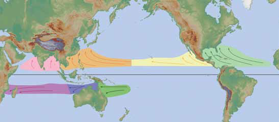
Tropical Cyclone formation regions with mean tracks (courtesy of the NWS JetStream Online School)
The NOAA Jetstream online school for Weather:
http://www.srh.noaa.gov/jetstream/tropics/tropics_intro.htm
A hurricane in the North Atlantic Ocean, the Northeast Pacific Ocean east of the dateline, and the South Pacific Ocean east of 160°E, (The word hurricane comes from the Carib Indians of the West Indies, who called this storm a huracan. Supposedly, the ancient Tainos tribe of Central America called their god of evil "Huracan". Spanish colonists modified the word to hurricane.),
A typhoon in the Northwest Pacific Ocean west of the dateline (super typhoon if the maximum sustained winds are at least 150 mph / 241 km/h),
A severe tropical cyclone in the Southwest Pacific Ocean west of 160°E or Southeast Indian Ocean east of 90°E,
A severe cyclonic storm in the North Indian Ocean, and
Just a tropical cyclone in the Southwest Indian Ocean.
http://www.srh.noaa.gov/jetstream/tropics/tc_classification.htm
Tropical Depression: A tropical cyclone with maximum sustained winds of 38 mph (33 knots) or less.
Tropical Storm: A tropical cyclone with maximum sustained winds of 39 to 73 mph (34 to 63 knots).
Hurricane: A tropical cyclone with maximum sustained winds of 74 mph (64 knots) or higher. In the western North Pacific, hurricanes are called typhoons; similar storms in the Indian Ocean and South Pacific Ocean are called cyclones.
Major Hurricane: A tropical cyclone with maximum sustained winds of 111 mph (96 knots) or higher, corresponding to a Category 3, 4 or 5 on the Saffir-Simpson Hurricane Wind Scale.
http://www.nhc.noaa.gov/climo/
Here is the most likely track of hurricanes for June:
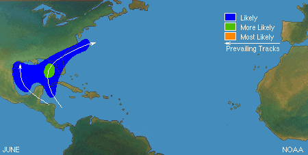
http://www.nhc.noaa.gov/climo/#ori10
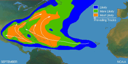
Compared that to September most likely tracks:
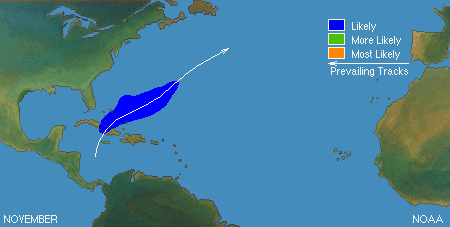
And November's most likely tracks:

lordsummerisle
(4,651 posts)For the update, not sure if the all caps
header was necessary though, only minor
impacts are expected here in SC.