Typhoon Haiyan Would Cover Nearly All Of United States (PHOTO)
Source: TPM
CAITLIN MACNEAL – NOVEMBER 11, 2013, 3:27 PM EST
The American Red Cross on Monday released this image of Typhoon Haiyan overlaid on a map of the United States showing how the massive storm would cover nearly the entire country.
Officials have estimated that the typhoon has killed up to 10,000 people in the Philippines this weekend.
Image via American Red Cross:
" "
"
###
Read more: http://talkingpointsmemo.com/livewire/image-of-typhoon-hayan-overlaid-on-u-s-map-highlights-storm-size-photo
 = new reply since forum marked as read
Highlight:
NoneDon't highlight anything
5 newestHighlight 5 most recent replies
= new reply since forum marked as read
Highlight:
NoneDon't highlight anything
5 newestHighlight 5 most recent replies
liberal N proud
(60,334 posts)truebrit71
(20,805 posts)Just. Wow.

phantom power
(25,966 posts)arcane1
(38,613 posts)


allan01
(1,950 posts) 

Ash_F
(5,861 posts)How often do storms that big occur?
Ash_F
(5,861 posts)It does a little more in depth analysis. Still pretty big.
http://www.newrepublic.com/article/115554/haiyan-isnt-large-united-states

DonViejo
(60,536 posts)what a surprise. NOT

kentauros
(29,414 posts)Here's a drawing representation of Super Typhoon Tip from 1979 that's more like what that false image wants Haiyan to be:
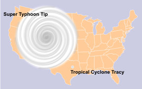
Weather Underground has a list of the twelve largest Atlantic cyclones here. The largest ones for the Pacific are Tip and this year's Wipha.

tclambert
(11,085 posts)DonViejo
(60,536 posts)On a TNR report that's being challenged?
James Schumaker
I'm not so sure. This is like the "which line is longer?" puzzle, when one line is bounded by arrows pointing in and the other by arrows pointing out. Unless you superimpose the NR pic of the hurricane directly over the Red Cross pic, and in the same false color image, it's very difficult to tell. Otherwise, it's just a case of whose optical illusion you want to believe.
tclambert
(11,085 posts)
BlueEye
(449 posts)The argument over the size of the storm relative to the continental United States reminds me of the West Wing episode about the Gall-Peters Projection map of the globe and how it affects our perception of power:
The bottom line: This thing was not 3,000 miles across... But it was still absolutely massive. Record breaking, in fact.
blkmusclmachine
(16,149 posts).