Latin America
Related: About this forumStudents build woven pavilion to shade archaeologists in Peru's desert
Bridget Cogley | 24 February 2019
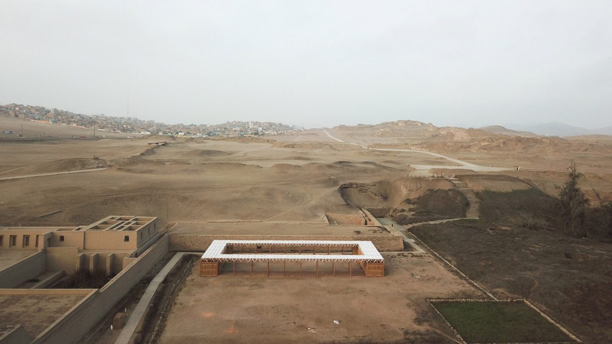
A woven white canopy, bamboo cane walls and earthen floors form this workspace for archaeologists on digs in Pachacamac, Peru, which was built by architecture students from Zurich and Lima.
The Room for Archaeologists and Kids is located an archaeological site 40 kilometres (25 miles) southeast of Lima. Called Pachacamac, it covers about 600 hectares of desert.
. . .
When viewed from overhead, the project only stands out with its white roof. Nearby are tiered buildings from centuries past, including perimeter walls of Acllawasi, where a selected group of Incan women inhabited.
"Its powerful underlying hill topography was extended upwards with adobe and stone temples and palaces to form what must have been an unbelievably impressive place – the largest hill later becoming the Temple of the Sun in the Incan era," reads the study.
"The sanctuary of Pachacamac is a most extraordinary constructed landscape... and one of the biggest and most important of such city-complexes in what is today Peru," it continues. "It was once an isolated citadel: a strategic point located where the River Lurin meets the ocean, from which the entire surrounding territory could be controlled."
More:
https://www.dezeen.com/2019/02/24/he-room-for-archaeologists-and-kids-pachacamac-studio-tom-emerson-taller-5-peru/?utm_source=feedburner&utm_medium=feed&utm_campaign=Feed%3A+dezeen+%28Dezeenfeed%29
Anthropology:
https://www.democraticunderground.com/12294516
 = new reply since forum marked as read
Highlight:
NoneDon't highlight anything
5 newestHighlight 5 most recent replies
= new reply since forum marked as read
Highlight:
NoneDon't highlight anything
5 newestHighlight 5 most recent replies

KY_EnviroGuy
(14,488 posts)Enter this line into Google Maps search:
Santuario Arqueologico de Pachacamac, Lurín, Peru
Then, click on satellite view and blow it up for a good inspection. Click on "Photos" to see some great details of the site.
Thanks, Judi Lynn!...........

Judi Lynn
(160,408 posts)I immediately saw a lot of those doors, shaped like these windows at Ollaytaytambo! So mysterious!

(Taken of Ollantaytambo in google images after a search for the shape of the doors.)
I can see I will need to spend a lot of time going over these photos tomorrow, because I really want to examine them.
This is a wonderful treat, something I'm really looking forward to doing.
What's really even more interesting is that the article above indicates what they've uncovered is a very, very small part of the structures. It would seem being an archeologist during this time in history would have to be amazing, now so much progress can be made so quickly with vastly improved technology!
Or would you rather be a troll every day? Just a little humor. Very little.
What a great photo feast. Thank you, very much.
On edit:
I have read the original structures in building along the Inca Highway were built by an earlier civilization, and that the Incas built upon the structures, which you can see very clearly at places like Macchu Picchu, the differences in the incredible power the first builders had over the stone material, and the later building.
It only intensifies one's curiosity about the people who were there before the Inca civilization.
KY_EnviroGuy
(14,488 posts)each window and door has a heavy lintel reinforcement above it, and the trapezoid shape makes me suspect this evolved that way to be stronger against earthquakes. Seems that it would be more stable and less likely to collapse from a shaker, which they have there almost every day!
I bet with a proper search, you will find some structural guys have analyzed this design feature.
..........
Judi Lynn
(160,408 posts)Overwhelming! Thank you.
http://tinyurl.com/y489ecxz
KY_EnviroGuy
(14,488 posts)(Warning, it can be very addictive, LOL). I'm speaking of Google Street View, where they've driven panoramic-view cameras through areas all over the world.
At the location we visited, go back to the map view, then double-click on the street going past the museum and dig site called Av. Antigua Panamericana Sur.
If the street tour is available (it is here, I tested it), you will see a little window pop up toward the bottom of the map. Double-click on that pop-up and it will take you to street view. To go down the street, just click on a point ahead of where you are, and you can rotate the view 360-degrees. You can also blow-up or reduce the view with your mouse wheel or the (+/-) icons.
Note also in Google Maps, you can hide the big info panel in the left side to give you a larger view of your area of interest.
Next, you may want to visit Paris or some of the quaint little villages in Italy. Note that in order to open the street view, you must double-click on a route where Google's cameras have driven. If they have been there, the little pop-up will show a photo rather than just a verbal description.
Remember where the mine tailings dam busted in Brazil a few weeks ago? You can actually take a Google Street View tour of the town called Brumadinho (State of Minas Gerais, Brazil) that's adjacent to that mine. I was shocked the Google had been there! Of course these recordings were made prior to the disaster, but it does give one a feel for the local culture.
Have fun!......

proud patriot
(100,703 posts) KY_EnviroGuy
(14,488 posts)Great relief for those of us that are retired but can't afford the real visits. I enjoy peeking at all the little shops in small towns and imagine being there in person.
..........
proud patriot
(100,703 posts)I live on the big Island of Hawaii after living in the SF bay area my whole life
45 years .. until 5 yrs ago when I moved here .. I love it but it's noce to check in
on my old haunts .
Judi Lynn
(160,408 posts)I can't quite get the hang of it, yet, but I won't let that stop me.
Very interested in seeing how this works.
Have seen a street level experience of Macchu Picchu, and it was a-ma-zing. Wow.
Thanks.
KY_EnviroGuy
(14,488 posts)if I had to use a laptop mouse pad, I would give up. Those thing are just too tiny for my stubby fingers.
I use a regular wireless desktop-style mouse and mouse pad, and that makes it easy to navigate Google's street-view photo maps. By holding down the left mouse button, you can pan up, down and side-to-side, and go all 'round 360-degrees. You can also zoom in and out either using the mouse wheel or the +/- buttons on Google maps.
To quickly move to a point far away, point your mouse cursor at a location on the street surface and click on that point. If the camera has been at that point, it will take you there immediately. You'll also notice a big arrow and lighter circle on the road ahead, and that shows you the direction the camera car was headed.
It's sort of fun to get lost on a street half-round the globe from me and then figure my way out. Of course, if we really get lost, we can always click back to map view and start over.
Best of luck and thanks again for all you do for DU.......