Environment & Energy
Related: About this forumArctic Temps 3-5 C Above October Averages; Ice Extent Loss Since 1980s = 1.5 Greenlands
Ever since human-forced climate change started to kick off dramatically worsening polar warming events in the 2000s, the Arctic has struggled to cool down to normal temperatures during fall and winter. However, for 2016, this failure of Arctic cooling appears to have grown even more pronounced.
Over the past few weeks, temperature anomalies for the entire region north of the 66th parallel have ranged between 3 and 5 degrees Celsius above average. These are very extreme departures — ones we typically have only seen during winter when the poleward heat energy transfer effects of human-caused climate change are at their strongest. But this fall, high local ocean temperatures have combined with a north-bound flood of warmth to turn the Arctic into a glaring global hot spot — featuring the highest above normal temperature readings for any region of the Earth.
New Record Daily Lows for Arctic Sea Ice
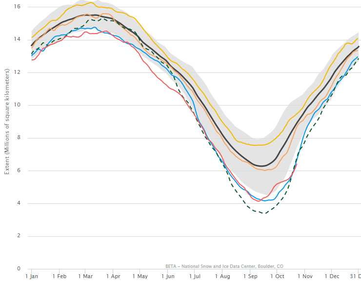
So much added heat has had a marked effect on sea ice. Last week, Arctic sea ice again dipped into record low ranges. Edging sideways away from the usual rapid refreeze trend line, by today these record low readings have become rather prominent in measures like those produced by the National Snow and Ice Data Center (NSIDC).
 ?w=600&h=470
(On October 23rd, 2016, Arctic sea ice hit a new record daily low extent of 6,434,000 square kilometers [pink line]. This beat out 2007’s previous record of 6,501,000 square kilometers [blue line] and is now trailing 2012’s October 23 measure of 6,785,000 square kilometers [dashed green line] by a substantial margin. 2016’s record low readings are now about 3 million square kilometers below same day readings for October 23 of 1981 [light orange line at top]. In other words, an area of sea ice approximately the size of one and a half Greenlands has disappeared over the intervening 35 year period. Image source: NSIDC.)
EDIT
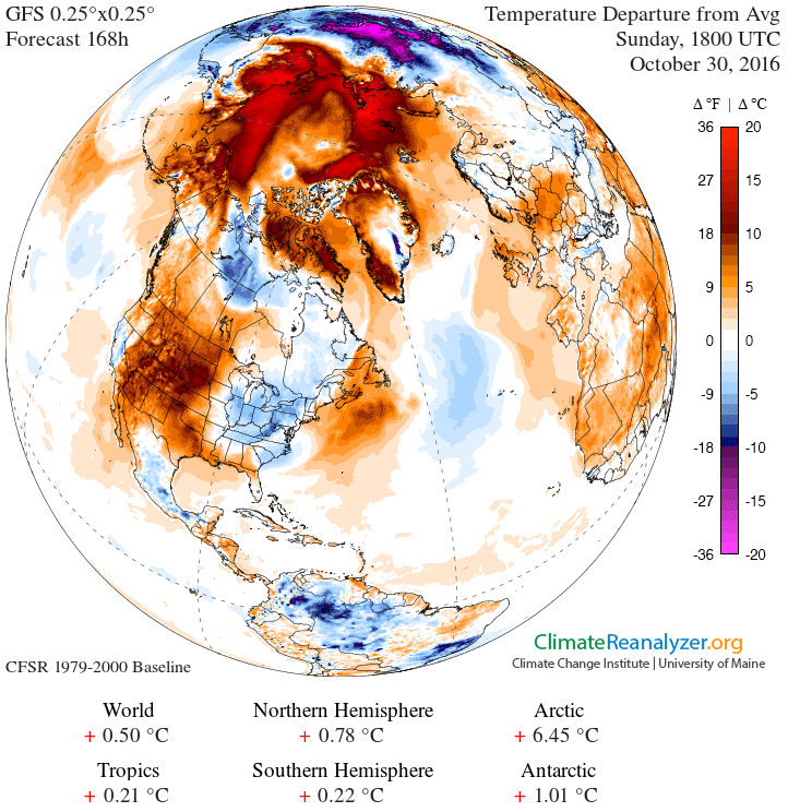
The anomalous heat build-up in the Arctic pushing sea ice levels to new all-time record low daily ranges is, unfortunately, expected to worsen over the coming week. Today’s beyond-normal temperature departures of around 4.35 degrees Celsius above average are predicted by GFS models to rise to around 6.45 C above average by Sunday. These high temperature readings are expected to concentrate in regions near the sea ice edge. And so much heat focusing exactly in the region where sea ice is attempting to expand risks a continued lagging of seasonal ice accumulation. 15-20 C above average temperatures are predicted to stretch from the Beaufort through the Chukchi, into the East Siberian Sea, on through the Kara, down along the Northern Edge of the Barents and into an Arctic Ocean zone just north of Greenland.
 ?w=600&h=618
(We’re currently witnessing a level of heat transfer into the Arctic that is probably unprecedented. So much heat heading north and building up at the pole due to local and global greenhouse gas buildup, ocean warming, loss of summer reflectivity, and increasingly powerful atmospheric gravity waves is now pushing Arctic sea ice into record low daily ranges. As October shifts toward November, this Arctic heat is likely to begin to produce some severe late fall and early winter weather conditions. In the above map, we begin to see a signature hot west, cool east dipole over the US. During past years, polar amplification has helped to generate this extreme weather pattern in the US where heat and drought is prevalent in the west while severe winter weather dominates the east. Image source: Climate Reanalyzer.)
EDIT
https://robertscribbler.com/2016/10/24/global-warming-is-winning-the-battle-against-arctic-sea-ice-extent-drops-to-new-record-lows/