Environment & Energy
Related: About this forumAnother Noreaster/Tropical Depression Combo On The Way? Sandy-Like Track Emerging
It’s not yet predicted to be a so-called perfect storm. But a Sandy-like situation appears to be on tap for the U.S. Northeast this weekend. For the forecast weather coming down the pipe bears a distinctly odd combination of features similar to the climate change related hybrid hyperstorms we’ve seen during recent years. To be clear, the presently predicted hybrid storm is not expected to be as intensely ‘perfect’ as Sandy. But it could still be a record-breaker for parts of the Northeast with regards to October rainfall and minimum central pressure come Sunday.
Tropical System Predicted to Combine with a Nor’Easter
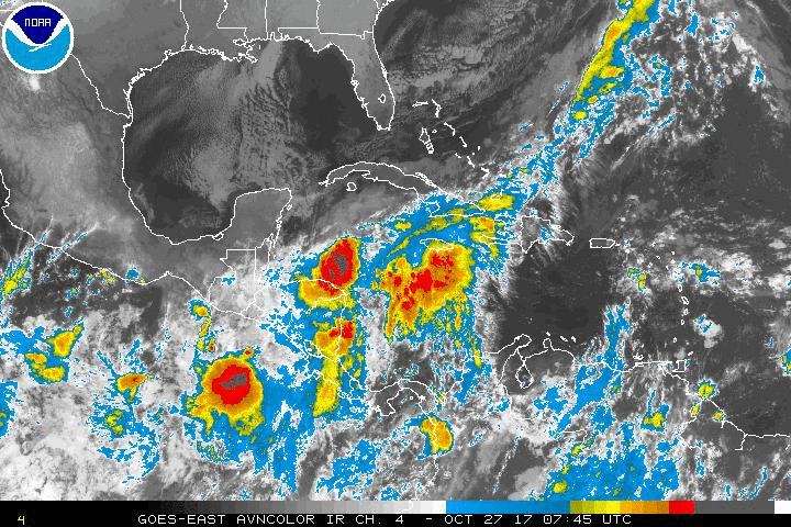
93 L isn’t even a tropical depression yet. But this stormy collection of clouds southeast of the Yucatan continues to gather and organize over warmer than normal waters. At this time, development into a tropical system appears more likely — with the National Hurricane Center predicting a 60 percent chance of storm development over the next 24 hours.
 ?w=600&h=400
(93 L becomes more organized Southeast of the Yucatan on Friday. Image source: The National Hurricane Center.)
To the north, a very deep trough is poised to plunge down over the Eastern Seaboard of the United States. Another one of those high amplitude Jet Stream waves born of conditions related to a warming Arctic. And all across the storm’s projected path sea surface temperatures range between 1 and 4 degrees Celsius above the climatological average.
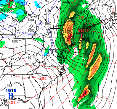
By Sunday, 93 L is predicted to be funneling into the southern section of this trough just east of Florida. Present model runs show the tropical storm transferring its warm energy northward into a low along the Arctic-originating frontal system over these warmer than normal waters — with potentially extreme results.
 ?w=600
(Northern New England doesn’t have a record of a storm with pressures lower than 980 mb during late October. The present storm could intensify to pressures lower than 980 mb as it crosses over this region late Sunday — setting a new record. Image source: Tropical Tidbits.)
EDIT
https://robertscribbler.com/2017/10/27/sandy-like-situation-developing-tropical-system-to-merge-with-potentially-record-breaking-noreaster-by-sunday/#comments
 = new reply since forum marked as read
Highlight:
NoneDon't highlight anything
5 newestHighlight 5 most recent replies
= new reply since forum marked as read
Highlight:
NoneDon't highlight anything
5 newestHighlight 5 most recent replies

Javaman
(62,510 posts)Now shut up and put in you hip waiters

sue4e3
(731 posts)I live on the Jersey side of the Delaware Bay. A little past time of my youth , Going out to the lighthouse and watching them come in.It is quite the sight. For ones like Sandy you batten down, say a little prayer and wait it out and if the ocean wants it, you leave and let the ocean have it back period