Welcome to DU!
The truly grassroots left-of-center political community where regular people, not algorithms, drive the discussions and set the standards.
Join the community:
Create a free account
Support DU (and get rid of ads!):
Become a Star Member
Latest Breaking News
General Discussion
The DU Lounge
All Forums
Issue Forums
Culture Forums
Alliance Forums
Region Forums
Support Forums
Help & Search
Environment & Energy
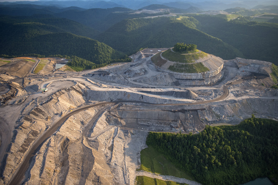
Related: About this forumMapping mountaintop coal mining's yearly spread in Appalachia
New mapping tool uses satellite images to track annual changes in mining's footprintDate:
July 26, 2018
Source:
Duke University
Summary:
A new mapping tool shows, in more detail than ever before, the land laid bare by mountaintop coal mining in central Appalachia each year, going back more than three decades. The tool uses satellite imagery to identify and map the annual extent of mining activity across portions of Kentucky, Tennessee, Virginia and West Virginia. The researchers say the updated maps will make it easier to assess and mitigate mining's environmental and health impacts.
The coal industry may have declined in the last decade because of the rise of cheap natural gas, but a coal mining method called mountaintop removal is still taking place, particularly in central Appalachia.
A new web-based mapping tool shows, in more detail than ever before, the land laid bare by mountaintop coal mining in central Appalachia each year, going back more than three decades.
The tool uses satellite imagery to identify and map the annual extent of mining activity across a four-state area including portions of Kentucky, Tennessee, Virginia and West Virginia.
In the journal PLOS ONE, researchers estimate that between 1985 and 2015, an average of 21,000 acres was converted to bare earth and rubble in central Appalachia each year -- an area about half the size of Washington, D.C.
More: https://www.sciencedaily.com/releases/2018/07/180726085959.htm

A new mapping tool uses satellite imagery to reveal where mountaintop coal mining is underway in Appalachia, going back more than three decades. Forested areas appear green, whereas mined areas appear yellow.
Credit: Christian Thomas, SkyTruth
InfoView thread info, including edit history
TrashPut this thread in your Trash Can (My DU » Trash Can)
BookmarkAdd this thread to your Bookmarks (My DU » Bookmarks)
4 replies, 1009 views
ShareGet links to this post and/or share on social media
AlertAlert this post for a rule violation
PowersThere are no powers you can use on this post
EditCannot edit other people's posts
ReplyReply to this post
EditCannot edit other people's posts
Rec (11)
ReplyReply to this post
4 replies
 = new reply since forum marked as read
Highlight:
NoneDon't highlight anything
5 newestHighlight 5 most recent replies
= new reply since forum marked as read
Highlight:
NoneDon't highlight anything
5 newestHighlight 5 most recent replies
= new reply since forum marked as read
Highlight:
NoneDon't highlight anything
5 newestHighlight 5 most recent replies
Mapping mountaintop coal mining's yearly spread in Appalachia (Original Post)
Rhiannon12866
Jul 2018
OP
I agree, it's unforgivable that they're still ravaging this beautiful country like this
Rhiannon12866
Jul 2018
#2

Duppers
(28,117 posts)1. Glad they're tracking this disastrous practice.
But how can we get the country to give a hoot? Too few even accept anthropogenic global warming. (Even had DUers disagree with me.)
This makes me sick because I love my mountains.
Thanks for posting this, Rhiannon.

Rhiannon12866
(205,074 posts)2. I agree, it's unforgivable that they're still ravaging this beautiful country like this
Yet another reason to get rid of Trump and his efforts to resurrect the coal industry and his absolute disregard for environmental protection. That photo is heart wrenching. 

Judi Lynn
(160,515 posts)4. Thank you for posting the picture. Everyone should know what happens. n/t
mountain grammy
(26,608 posts)3. Disgusting practice for a dying industry..
hellbent on destruction on their way out.