Welcome to DU!
The truly grassroots left-of-center political community where regular people, not algorithms, drive the discussions and set the standards.
Join the community:
Create a free account
Support DU (and get rid of ads!):
Become a Star Member
Latest Breaking News
General Discussion
The DU Lounge
All Forums
Issue Forums
Culture Forums
Alliance Forums
Region Forums
Support Forums
Help & Search
Environment & Energy
Related: About this forumimage of the arctic low pressure system:
SFC...A 965 MB LOW WHICH IS AN UNUSUALLY DEEP LOW FOR ANY TIME OF THE YEAR IN THE ARCTIC OCEAN IS NOW VERTICALLY STACKED UNDER THE LOW ALOFT. THE LOW WILL ONLY VERY SLOWLY FILL THROUGH THE MIDDLE OF THE WEEK BUT WILL STILL BE A FORMIDABLE 980 MB LOW ON WEDNESDAY.

http://neven1.typepad.com/blog/2012/08/arctic-storm-part-1.html?cid=6a0133f03a1e37970b017743f4a7ec970d

http://neven1.typepad.com/blog/2012/08/arctic-storm-part-1.html?cid=6a0133f03a1e37970b017743f4a7ec970d
InfoView thread info, including edit history
TrashPut this thread in your Trash Can (My DU » Trash Can)
BookmarkAdd this thread to your Bookmarks (My DU » Bookmarks)
11 replies, 2118 views
ShareGet links to this post and/or share on social media
AlertAlert this post for a rule violation
PowersThere are no powers you can use on this post
EditCannot edit other people's posts
ReplyReply to this post
EditCannot edit other people's posts
Rec (8)
ReplyReply to this post
11 replies
 = new reply since forum marked as read
Highlight:
NoneDon't highlight anything
5 newestHighlight 5 most recent replies
image of the arctic low pressure system: (Original Post)
phantom power
Aug 2012
OP
Um, shouldn't summer be the time of year for the least powerful non-tropical lows?
Denninmi
Aug 2012
#3
phantom power
(25,966 posts)1. ah, got the url working
phantom power
(25,966 posts)2. and by the way, 965 mb (!)
Denninmi
(6,581 posts)3. Um, shouldn't summer be the time of year for the least powerful non-tropical lows?
Aren't temperate and arctic, so called "cold-core" systems deepest, with the lowest pressures, during the coldest times of the year? And at a minimum during the season of peak heating?
I'm no scientist, mind you, but I think the above is essentially correct, no doubt with various disclaimers.
But, you know, there's nothing going whack with climate. Keep moving, keep moving, nothing to see here.
phantom power
(25,966 posts)4. Jeff Masters sez: very rare
A remarkably intense low pressure system formed in the Arctic north of Alaska Monday, bottoming out with a central pressure of 963 mb at 2 pm EDT. A pressure this low is rare any time of the year in the Arctic, and is exceptionally so in summer. The storm is stacked vertically with the upper-level low, and will spin in place and slowly weaken over the next few days, but remain unusually strong. Strong winds behind the low's cold front caused a 1.3' storm surge Monday in Prudhoe Bay, on Alaska's north shore. As noted in Neven Acropolis' sea ice blog, the strong winds around this low have the potential to cause a large loss of Arctic sea ice, due to churning, increased wave action, pushing of ice into warmer waters, and the mixing up of warmer waters from beneath the ice. According to the latest analysis from the National Snow and Ice Data Center, Arctic sea ice extent was at a record low extent as of August 1. This week's big storm will likely keep Arctic sea ice at record low levels for the next week or two.
http://www.wunderground.com/blog/JeffMasters/comment.html?entrynum=2174
http://www.wunderground.com/blog/JeffMasters/comment.html?entrynum=2174
hatrack
(59,566 posts)7. Oh, and btw, this pressure is about the same as that associated with Cat 2 hurricanes further south
phantom power
(25,966 posts)9. right then

Denninmi
(6,581 posts)5. All of this is starting to remind me of that movie 'The Day After Tomorrow'
Which was dreck in more than one way. But the overall feeling that our climate is about to freak out big time is strong for me right now.
hatrack
(59,566 posts)6. Really good thread over on Kos about the storm

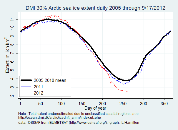
Including this interesting graphic . . .
Neven's Storm Warning post covers this in part (13+ / 0-)
I didn't want to drag out my diary, but Neven's excellent storm warning post linked in the intro of my diary covers at least some of the immediate mechanics of how storm churn will pump saltier water from 30+ feet below and then literally get dumped up and onto the sea ice.
Additionally, it sounds like fragments of ice that have algae blooms clinging to their bottom can get up ended and these can then decrease the albedo effect.
In the comments, the thing the hardcore ice-nerds (a term I use respectfully!) seem most obsessed with is solid parts of the polar pack breaking off into floes and heading south into warmer waters as well as that section of ice near Siberia separating entirely from the ice pack.
I guess that has not happened yet?
EDIT
http://www.dailykos.com/story/2012/08/07/1117576/-Current-Cyclone-North-Pole-Record-Low-Ice-in-2012
GliderGuider
(21,088 posts)8. .
Last edited Wed Aug 8, 2012, 07:04 AM - Edit history (1)
.
pscot
(21,024 posts)11. This should be on top
K&R