Environment & Energy
Related: About this forumBad news for California - El Nino looks like a bust
California gets their rain during El Nino years, but from the following GIF, it looks like it has already spent it's strength. Unfortunately for Alaska, it also looks like sub-surface temperatures are rebuilding in the north Pacific which was the pattern last year when they had record high winter temperatures.
PS, I know it's from Bob Tisdale, but the data comes from NOAAs GODAS.

 = new reply since forum marked as read
Highlight:
NoneDon't highlight anything
5 newestHighlight 5 most recent replies
= new reply since forum marked as read
Highlight:
NoneDon't highlight anything
5 newestHighlight 5 most recent replies

Warpy
(111,241 posts)I suppose it means the southwest will have the monsoons fizzle out again this year, as they have every year since 1992 but one.

upaloopa
(11,417 posts)Of climate change.
OnlinePoker
(5,719 posts)Something that hasn't occurred in the last couple of years due to a La Nina pattern in the ocean. Unfortunately, the west has suffered 200 year mega-droughts in the past (during the middle ages) so this could only be the start of a disastrous era for the millions of people who have chosen to live in a region with a history of major rainfall fluctuations.
http://www.mercurynews.com/portlet/article/html/imageDisplay.jsp?contentItemRelationshipId=5689627
happyslug
(14,779 posts)The European Warm period started about 850 to 1300 you had a warm period, followed by the little ice age. Some people use 950 to 1250. Peaking between 850 to 1100 AD.
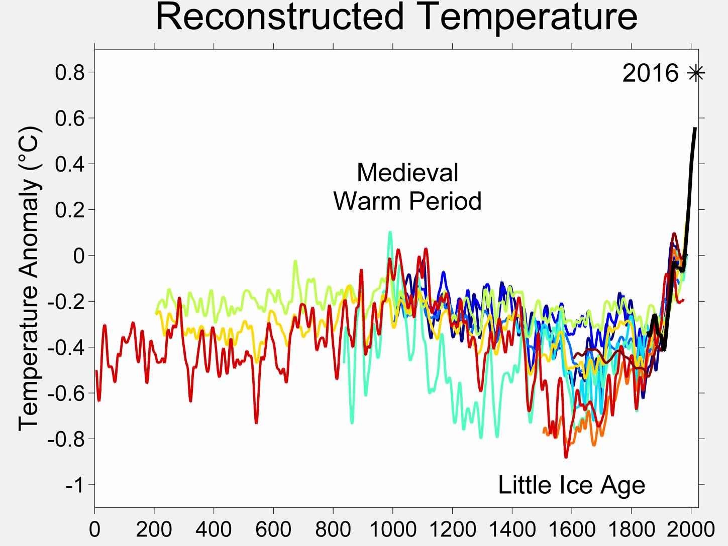
http://en.wikipedia.org/wiki/Medieval_Warm_Period

In your article the dry period was about 850 to 1050 and again 1120 to about 1280.
Thus what appears to have caused the American Southwest to be dry, caused Europe to be warm and wet at about the same time period. When Europe turned colder, the American Southwest turned wetter. The reversed was seen in the 900s, as Europe turn warmer, the American Southwest became drier.
El Nino may explain both situations. In an El Nino year, cold weather from the Antarctic runs up the West Coast of South America bring with in a lot of fish. When an El Nino hits what is now Central America it can no longer go north and starts a circle to go south (this is a simplification the actual action is much more complex). Present theory it the cold water absorbs the heat from the surface causing the area to cool down, so few if any Hurricane for, this includes NOT only in the Eastern Pacific but also the Caribbean. With less hurricanes, water flow stays to the south and does NOT flow into the Great Plains or the American South West. There is a debate if this is cause by the lack of hurricanes OR the lack of Hurricane is just another result of the general cooler temperatures. For the Southwest and Great Plains this debate is moot, they are just drier no matter if it is hurricane related or not.
The reverse appears also to be true, when Europe turned colder after about 1300, the American Southwest turned drier.
The real issue is WHY? With warmer world wide temperatures the Antarctic Ice Sheets appears to have lost mass, and that loss of mass turned into the cold waters of an El Nino. Drying out the American Southwest. The effect on Europe may be caused by an acceleration of the Gulf Stream. With less storms do to the growing coolness in the Eastern Pacific, but the Caribbean NOT directly affected by the Cold Waters of the El Nino, getting hotter thus driving the Gulf Stream FASTER AND STRONGER to Europe where it releases its excess heat and warms Europe.
When you have an La Nina (No Cold water surge) the eastern Pacific warms up and you have increase weather in that area that spreads to the Caribbean. This increase weather absorbs more of the heat from the sun, and thus you end up with more rain in the Caribbean, but also less heat building up so the Gulf Stream slows down and weakens (and Europe cools down as a result).
Now, one theory that lead to the Medieval Warm Period is increase volcanic activity that sent more Carbon Dioxide into the Atmosphere. This warmed up the earth and increase the melting of the West Antarctic Ice Sheet (Where El Nino gets its cold water from). The differences in decades between the weather in Europe Changing and the Weather in the Southwest Changing may be do to error in calculating when the change occurred (records are at best incomplete), BUT it may be a reflection that one started decades before the other for it took decades to reverse what was already in place. More Decades in some areas then in others.
The Middle Ages Warm Period shows us some of the affect we are seeing today. The West Antarctic Ice Sheet is melting making stronger El Ninos, which is drying out the American Southwest, while the Caribbean is getting warming causing the Gulf Stream to speed up warming Europe.
Thus both the drying of the American Southwest and the Warming of Europe are tied in with the general warming of the planet do to Global Warming.
JayhawkSD
(3,163 posts)Less than 200 years ago the Santa Cruz River in Tucson, AZ had water in it all year at a level which sustained a fish population. Climate change caused it to dry up in the late 1800's. Earlier, the Anazazi people built large cities in the Northern Arizona desert. No one knows for certain why they left, but it seems likely that loss of water supply was at least part of the reason, because the local climate is too dry to support the population that is evidenced by the size of the cities that are left behind.
Climate change is faster and more widespread now, due to the actions of man and the larger population, but no single weather issue can be attributed directly to climate change. Is climate change a factor in our drought? Almost certainly it is, but it is exaggeration to say that it is the reason for our drought. Weather patterns have been changing, back and forth, since the dawn of time.
happyslug
(14,779 posts)The movement of the what is now called the Ancient Pueblo people (Anazazi is Najaho for either "Ancient Enemy", "Ancestor of our enemy", or "Ancestor Ones" it is NOT a named liked by the Pueblos themselves) occurred about 1300 as the Dry Period ENDED and a wetter period began. Present theory say the drought drove them to move, but an alternative theory is that the sudden increase in rain in locations to their south caused them to move before the rain reached their own area.
Another characteristic of the Anazazi settlements in the period ending in 1300, is that the ones most commented (the Cliff Dwellings) on today do NOT appear to be for the whole tribe, just the tribal leadership. A comparison can be made about British Hill Forts before and after the Roman Occupation. Pre Roman Occupation British Hill Forts were large enough to take in all members of the Tribe, post Roman Hill Forts (they reappeared after 410 when Rome Abandoned Britain) are much smaller and clearly intended for the ruling elites. i.e the peasants were on their own. In Britain this lead to massive defection of the peasants into the arms of the invading Angles and Saxons and is believed by many WHY, alone of the former Roman Provinces, none of the old Roman Administrative lines survive and except for one or two cities (York is the best known of them) Roman City lines did not survive the Conquest of Britain by the Saxons, Jutes and Angles (Eng;and is a corruption of the Ancient name for the Angle Tribe, it is from that tribe language modern English is decedent from).
http://en.wikipedia.org/wiki/Anglo-Saxons
http://en.wikipedia.org/wiki/Hillforts_in_Britain
I bring up the English Hill Forts and the difference between pre and post Roman British Hill Forts for the difference appears why the Cliff Dwellers appear to be small compared to earlier and later Pueblo dwellings. As the drought became worse, the ruling elite sought protection for themselves from the lower classes, thus the building of the cliff dwellings and they becoming harder and harder to enter and exit. Something happened about 1300 (a Revolution would be a good word, but the participates did not know that word and also wanted to keep up the appearance of being the same people). In 1300 something hit and the whole tribe moved, worse, it may be the peasants left to what they thought were greener pastures and the old ruling elite had to follow them.
The tribe moved to areas where increase rain had started so the move was to the tribes benefit.
http://en.wikipedia.org/wiki/Cliff_Palace
Similar revolts of peasants have occurred among other ancient people, the most famous is the Roman Peasants abandonment of Rome, but in the case of Rome the Roman Elite saw the errors of their ways and made accommodations with the peasants. The main problem after 267 BC was the Roman Plebeians no longer had the unity to do a strike mostly do to the increase numbers of slaves the Roman Elites were even then slowly turning to in place of free Plebeians.
http://en.wikipedia.org/wiki/Secessio_plebis
http://en.wikipedia.org/wiki/Conflict_of_the_Orders
Just a comment on why the Anazazi moved when they did, something happened around 1300 and it looks like a peasant revolt that the elite had to learn to live with. Like the Roman Plebeian strikes efforts were made to mask the class conflict and to minimize it but evidence of it does survive and is the best explanation of why the move took place as the drought ENDED.
One last comment Karl Marx is credited with determining when a Revolution occurs. He observed that revolutions NEVER occur as things go down hill. The Ruling Elite builds up forces to protect themselves from such a revolt, but no revolt occurs as things go down hill. Revolutions occur as things bottom out and things start to improve. Thus the worse year for France was 1787, things had bottomed out and improving when the Revolution of 1789 occurred. Another Famine hit Europe 1844-1846, leading to the Revolution of 1848 again as things bottomed out and improved. The Russian Revolution occurred in 1917, as the situation in Russia improved after the bad years of 1915 and 1916 (They started to improve in the fall of 1916).
Thus a good crop year may have lead the Peasants to have enough food to abandon their old lands to move elsewhere and the elite followed them. Given 1300 is given as the END of that Drought, that may be why the people moved.
4139
(1,893 posts)4139
(1,893 posts)NCEP Global Ocean
Data Assimilation System (GODAS)
http://www.cpc.ncep.noaa.gov/products/GODAS/

pscot
(21,024 posts)Here's the summary from NOAA's El Niño page. They'll update on the 10th.
Above-average sea surface temperatures (SST) expanded over the equatorial Pacific Ocean during May 2014 (Fig. 1), though the collective atmospheric and oceanic state continued to reflect ENSO-neutral. All of the Niño indices increased during the month, with the latest weekly values between 0.6oC and 1.6oC (Fig. 2). In contrast, subsurface temperature anomalies decreased over the last two months (Fig. 3), but still reflect a large pool of above-average temperatures at depth (Fig. 4). The low-level winds over the tropical Pacific remain near average, except for westerly anomalies over the eastern Pacific. At upper-levels, anomalous easterly winds have predominated over most of the equatorial Pacific. Unlike the previous month, convection was near average across most of the tropics (Fig. 5). The lack of a clear atmospheric response to the positive SSTs indicates ENSO-neutral, though the tropical Pacific continues to evolve toward El Niño.
Over the last month, the chance of El Niño and its ultimate strength weakened slightly in the models (Fig. 6). Regardless, the forecasters remain just as confident that El Niño is likely to emerge. If El Niño forms, the forecasters and most dynamical models, such as NCEP CFSv2, slightly favor a moderate-strength event during the Northern Hemisphere fall or winter (3-month values of the Niño-3.4 index between 1.0oC and 1.4oC). However, significant uncertainty accompanies this prediction, which remains inclusive of a weaker or stronger event due to the spread of the models and their skill at these lead times. Overall, the chance of El Niño is 70% during the Northern Hemisphere summer and reaches 80% during the fall and winter (click CPC/IRI consensus forecast for the chance of each outcome).
OnlinePoker
(5,719 posts)They have kept the same percentages, but they have dropped the expected El Nino strength from moderate to weak-moderate and have noted "subsurface heat content anomalies (averaged between 180-100 W) have decreased substantially since March and are now near average."
"Synopsis: The chance of El Niño is about 70% during the Northern Hemisphere summer and is close to 80% during the fall and early winter.
During June 2014, above-average sea surface temperatures (SST) were most prominent in the eastern equatorial Pacific, with weakening evident near the International Date Line (Fig. 1). This weakening was reflected in a decrease to +0.3°C in the Niño-4 index (Fig. 2). The Niño-3.4 index remained around +0.5°C throughout the month, while the easternmost Niño-3 and Niño-1+2 indices are +1.0°C or greater. Subsurface heat content anomalies (averaged between 180º-100ºW) have decreased substantially since late March 2014 and are now near average (Fig. 3). However, above-average subsurface temperatures remain prevalent near the surface (down to 100m depth) in the eastern half of the Pacific (Fig. 4). The upper-level and low-level winds over the tropical Pacific remained near average, except for low-level westerly anomalies over the eastern Pacific. Convection was enhanced near and just west of the Date Line and over portions of Indonesia (Fig. 5). Still, the lack of a clear and consistent atmospheric response to the positive SSTs indicates ENSO-neutral.
Over the last month, no significant change was evident in the model forecasts of ENSO, with the majority of models indicating El Niño onset within June-August and continuing into early 2015 (Fig. 6). The chance of a strong El Niño is not favored in any of the ensemble averages for Niño-3.4. At this time, the forecasters anticipate El Niño will peak at weak-to-moderate strength during the late fall and early winter (3-month values of the Niño-3.4 index between 0.5°C and 1.4°C). The chance of El Niño is about 70% during the Northern Hemisphere summer and is close to 80% during the fall and early winter (click CPC/IRI consensus forecast for the chance of each outcome)."

truedelphi
(32,324 posts)Are just as hamstrung from getting to discuss certain realities as people are here.
<sigh>
Demeter
(85,373 posts)If you want rain, go to Cleveland. It rained like hell Last Monday (on my way across turnpike) to the point of blindness, and it was doing it again today, as I drove back.