February continues streak of record low Arctic sea ice extent
Arctic sea ice was at a satellite-record low for the second month in a row. The first three weeks of February saw little ice growth, but extent rose during the last week of the month. Arctic sea ice typically reaches its maximum extent for the year in mid to late March.
Arctic sea ice extent for February averaged 14.22 million square kilometers (5.48 million square miles), the lowest February extent in the satellite record. It is 1.16 million square kilometers (448,000 square miles) below the 1981 to 2010 long-term average of 15.4 million square kilometers (5.94 million square miles) and is 200,000 square kilometers (77,000 square miles) below the previous record low for the month recorded in 2005.
...
NASA and NOAA announced that January 2016 was the ninth straight month of record-breaking high surface temperatures for the globe. In terms of regional patterns, the Arctic stands out, with surface temperatures more than 4 degrees Celsius (7.2 degrees Fahrenheit) above the 1951 to 1980 average. These high temperatures were in part responsible for the record low sea ice extent observed for January. Persistent warmth has continued into February; air temperatures at the 925 hPa level were 6 to 8 degrees Celsius (11 to 14 degrees Fahrenheit) above the 1981 to 2010 average over the central Arctic Ocean near the pole. The rate of ice growth for February was near average at 19,700 square kilometers (7,600 square miles) per day, compared to 20,200 square kilometers (7,800 square miles) per day for the 1981 to 2010 average.
http://nsidc.org/arcticseaicenews/2016/03/february-continues-streak-of-record-low-arctic-sea-ice-extent/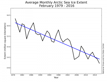
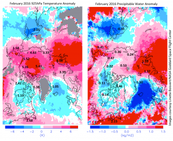
These two images show February 2016 departures from the 2003 to 2015 average for 925 hPa air temperature (left) and precipitable water (right) as derived from the NASA AIRS instrument.
 = new reply since forum marked as read
