Israel/Palestine
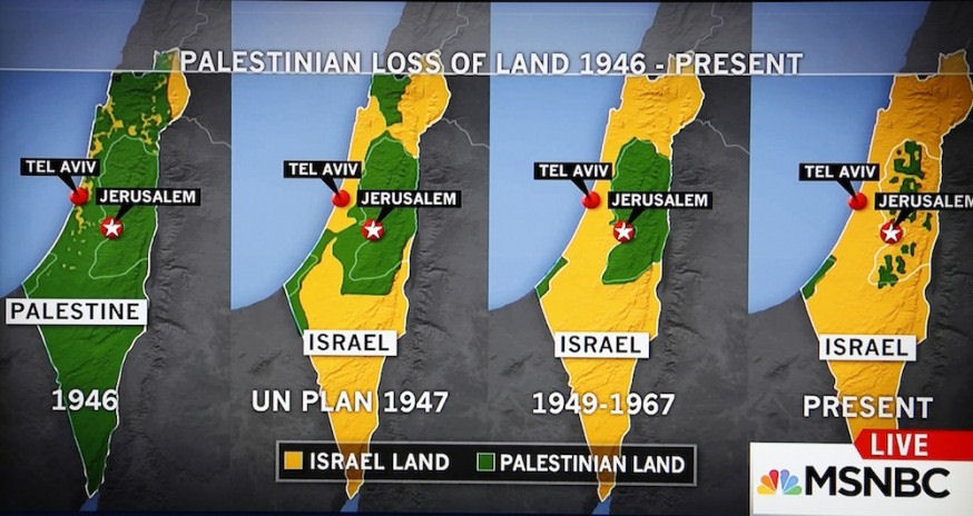
Related: About this forumFact Check: MSNBCs Palestinian loss of land map
http://mondoweiss.net/2015/10/check-msnbcs-palestinianDoes the map accurately show the loss of Palestinian land since 1946?
Yes. The map accurately depicts the land that has been forcibly taken from Palestinians since 1946, two years before Israel was established and the accompanying expulsion of between 750,000 and a million Palestinians to make way for a Jewish state.
During and immediately following the state’s creation in 1948, Israel expropriated approximately 4,244,776 acres of Palestinian land. In the process, more than 400 Palestinian cities and towns were systematically destroyed by Israeli forces or repopulated with Jews. Most Palestinian population centers, including homes, businesses, houses of worship, and vibrant urban centers, were demolished to prevent the return of their owners, now refugees outside of Israel’s pre-1967 borders or internally displaced within them. (See here for interactive map of Palestinian population centers destroyed during Israel’s creation.)
Israel’s systematic dispossession of Palestinians is ongoing today, both in the occupied territories and inside Israel’s internationally recognized pre-1967 borders, where Palestinian citizens of the state and those living under occupation continue to be pushed out of their homes and off their lands – including entire towns – to make way for Jewish citizens and settlers. Today, there are approximately 650,000 Jewish settlers living illegally on occupied Palestinian land in the West Bank and East Jerusalem, and Israel’s settlement enterprise covers approximately 42% of the West Bank.
 = new reply since forum marked as read
Highlight:
NoneDon't highlight anything
5 newestHighlight 5 most recent replies
= new reply since forum marked as read
Highlight:
NoneDon't highlight anything
5 newestHighlight 5 most recent replies

bvar22
(39,909 posts)Here is the map:
oberliner
(58,724 posts)There was no Israel at the time.
bvar22
(39,909 posts)That is one reason why I posted the map.

azurnoir
(45,850 posts)but if there was no Israel in 1946 is the best that can be done the words 'weak sauce' come to mind
bvar22
(39,909 posts)there were Jewish enclaves in the area called Palestine that pre-date the 1946 mandate. While this land was not a country named "Israel", the first map could be showing the Jewish enclaves that pre-date the formation of the country named Israel.
I'm not arguing either way, but this information could be what is shown in map 1 above.
<snip>
The 1922 Palestine Order in Council established a Legislative Council, which was to consist of 23 members: 12 elected, 10 appointed, and the High Commissioner. Of the 12 elected members, eight were to be Muslim Arabs, two Christian Arabs and two Jews. Arabs protested against the distribution of the seats, arguing that as they constituted 88% of the population, having only 43% of the seats was unfair.
https://en.wikipedia.org/wiki/Mandatory_Palestine
shira
(30,109 posts)It was a proposal (Partition Plan).
The 3rd map ('49-'67) pretends the green areas across the armistice lines of '48 were Palestinian. They were not, as they were under illegal Egyptian and Jordanian control.
oberliner
(58,724 posts)In the interest of accuracy, it should have had the two areas labelled as "Proposed Jewish State" and "Proposed Arab State".
One would think that would be the sort of thing that would come up in a "fact check".
R. Daneel Olivaw
(12,606 posts)oberliner
(58,724 posts)It just mentions, as I did, that Israel did not exist in 1946.
It does not explain what the yellow area is meant to represent in the first map.
R. Daneel Olivaw
(12,606 posts)It showed the Syrian Golan Heights, which have been under Israeli military occupation since the 1967 War, as part of Israel, although the international community, including the United States, does not recognize Israeli sovereignty over the area.
The map also shows “Israel” existing in 1946. While British Mandatory Palestine did exist in 1946, there was no political entity called “Israel” until 1948.
oberliner
(58,724 posts)If they don't represent anything, then the entire first map is meaningless.
In which case, this "fact check" should've concluded that the maps were inaccurate since the first map doesn't show anything.
shira
(30,109 posts)Meanwhile the green does not show private Palestinian property in comparison.
In fact, in 1946 all of that was British occupied. That map should be one color throughout.
oberliner
(58,724 posts)The weird thing is that one could make a similar propaganda point with accurate maps (such as the one of the West Bank settlement expansion), but these dumbed-down BS ones are more visually effective, I guess.
oberliner
(58,724 posts)Is there not a general consensus regarding that blog?
R. Daneel Olivaw
(12,606 posts)oberliner
(58,724 posts)Check previous threads for some really detailed back and forth about them.
R. Daneel Olivaw
(12,606 posts)For once at least.
oberliner
(58,724 posts)If you agree that there was no Israel in 1946, then what distinguishes the green areas from the yellow areas in the first map?
R. Daneel Olivaw
(12,606 posts)I'll knock it right back into your pen.
For once at least.
oberliner
(58,724 posts)This article purports to be a "fact check" of the maps.
The first map has some areas in yellow labeled "Israel land" even though there was no Israel (which the article also notes).
Since we are in agreement that there was no Israel at the time, what do the areas in yellow represent?
One would think that would be a pretty reasonable question to address in a "fact check" of the maps.

King_David
(14,851 posts)Mondoweiss is a hate site as has been demonstrated amply .
Why any "Democrat" would post that site here is revealing all of itself and shows something .
Mondoweiss has trashed Bernie Sanders as well as Hillary and is a trash site.
 ?v=1435252877
R. Daneel Olivaw
(12,606 posts)I'm embarrassed for your failed attempts at censorship.

FBaggins
(26,727 posts)The entire OP is disinformation.
The closest thing to an attempt at censorship on the thread is your ridiculous attempt to keep others from pointing out the disinformation and just "deal with it" instead.
R. Daneel Olivaw
(12,606 posts)Yes. The map accurately depicts the land that has been forcibly taken from Palestinians since 1946, two years before Israel was established and the accompanying expulsion of between 750,000 and a million Palestinians to make way for a Jewish state.
What's truly laughable is how desperate some are to pretend the above never hapoened.
FBaggins
(26,727 posts)I can't see anyone claiming that no Palestinian land was ever taken.
Merely the correction that the maps (and the site's spin on those maps) do not accurately reflect reality - when they don't.
The only "desperation" shown here is the ridiculous attempt to pretend otherwise (as you continue to do above).
R. Daneel Olivaw
(12,606 posts)29. Laughable
The entire OP is disinformation
FBaggins
(26,727 posts)I suppose we shouldn't be surprised at historical revisionism if you can't even get past a couple posts without building a strawman out of them.
R. Daneel Olivaw
(12,606 posts)Why should you be surprised when Netanbooboo does it right along wirh the rest of the right wing zionists...and their tireless defenders on DU?

FBaggins
(26,727 posts)Also not a surprise.
What happened to "dealing with" the subject of the OP?
R. Daneel Olivaw
(12,606 posts)Deal.
shira
(30,109 posts)
Little Tich
(6,171 posts)Those maps are spectacularly wrong, and they shouldn't be part of any serious discourse on the displacement of Palestinians and the stealing of their land. This institute for Middle East Understanding is no better than CAMERA (which is one of the most inaccurate websites on the internet, not a small feat), at least when it comes to maps.
The problem is that each map is inaccurate on its own and each one shows different factors than than the last one. They've been thoroughly debunked already, and I don't understand why they're still around.
azurnoir
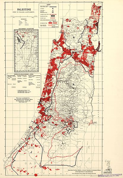
(45,850 posts)http://www.israeltoday.co.il/NewsItem/tabid/178/nid/27609/Default.aspx

Little Tich
(6,171 posts)They can be debunked as easily as the ones in the OP, which is probably your point. I distinctly remember having refuted the first two myself.
Two wrongs don't make a right.
azurnoir
(45,850 posts)or do you like so many others here hold fast to the there is no Palestine meme? Something that comes almost as a surprise to me
Little Tich
(6,171 posts)It's just that all those maps have been created to fit a particular argument and they don't conform well to reality. It's probably not possible to fit the actual history of Palestine into a succession of maps that purport to show loss of Palestinian (or in the example you provided, loss of Eretz Yisrael) lands.
The immigration of Jews into Palestine isn't the same kind of event as the ethnic cleansing in 1947 and 1948, nor are they similar to the invasion of Palestinian lands held by Egypt and Jordan in 1967. Each of these events are well described as separate events with a beginning and an end, and the accompanying maps on Wikipedia and elsewhere are correct.
Of course there was a Palestine and of course there was a Palestinian people. It's just that the self-identity of Palestinians didn't conform to modern Western notions of peoplehood and nationhood. Regardless, it was a naughty thing to do to forcibly remove the Palestinians against their will, and I think that Israel will eventually have to let their descendants return if they would want to.
shira
(30,109 posts)Why do you think that happened?
1. Due to war, real threat?
2. Racism, malice?
3. Other?
Little Tich
(6,171 posts)The idea was that a people without a land should settle a land without people. I can recommend that you read Ilan Pappé's "The Ethnic Cleansing of Palestine", which argues very convincingly that the removal of Arabs was planned all along, and that the hostilities in 1947 and 1948 were just an excuse for executing this plan.
Anyway, I strongly support the right of any individual to live in their ancestral homeland, which means that I support the right of return for all Palestinian refugees.
shira
(30,109 posts)Fascinating.
FBaggins
(26,727 posts)"Israel" is a political entity. "Palestinians" are people.
How does the map show land that is owned by Palestinians... but politically controlled by Israel? It shows it as part of Israel.
How does the map show land that was owned by jews... but politically controlled as part of the Palestine Mandate? It shows it as Israel (inexplicably).
How does the map show land that was politically controlled by the British, but not owned by anyone (because it's empty desert)? It shows it as being taken by Israel.
It doesn't even appear to accurately represent the map from Palestinian sources at the time:
oberliner
(58,724 posts)Hopefully it will sink in eventually.