Welcome to DU!
The truly grassroots left-of-center political community where regular people, not algorithms, drive the discussions and set the standards.
Join the community:
Create a free account
Support DU (and get rid of ads!):
Become a Star Member
Latest Breaking News
General Discussion
The DU Lounge
All Forums
Issue Forums
Culture Forums
Alliance Forums
Region Forums
Support Forums
Help & Search
Science
Related: About this forumLightning Research Flashes Forward
A greater understanding of lightning mechanisms is spurring the development of more accurate weather forecasting, increased public health precautions, and a more sophisticated understanding of lightning itself.
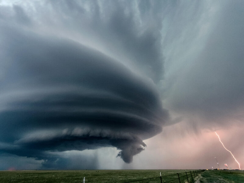
Lightning flashes during a tornadic storm in Oklahoma. Credit: Media Drum World/Alamy Stock Photo
By Heather Goss 24 April 2020
Ashley Ravenscraft had a decision to make. Over the past several hours as a storm rolled through northern Alabama on 11 January, her team at the National Weather Service (NWS) office in Huntsville had already issued two tornado warnings.
Ravenscraft, a meteorologist, had issued the warnings using the Three Ingredients Method, which uses radar inputs to estimate the likelihood a linear storm will shift into a vortex. Then the azimuth motor went down on the closest radar to the storm—a technician had been sent to repair it, but it would be a least an hour before he arrived and would be able to get it back online. The remaining radar stations were far enough from the storm that they were capturing only data above several thousand meters in altitude—too high to make accurate judgments on storm rotation close to the ground.
But Ravenscraft was getting consistent data about one piece of the storm that would become key: lightning.
The NWS had brought a new application online in 2018—Ravenscraft was using it for only the second time. Her color-coded screen was showing 1-minute flash extent density data, or the rate at which lightning was flashing in the area. It was pulling in real-time data from the Geostationary Lightning Mapper (GLM), a near-infrared instrument aboard the GOES-R satellite. As the frequency of flashes increases, the colors on the map move from cool to warm.
A month earlier, on 16 December 2019, Ravenscraft had been on radar for her first big storm and had GLM data up on her screen. As the storm line approached the Huntsville region through northern Mississippi, “I was watching the nature of the lightning jumps [the flash extent density data]—how high it got, how quick it got,” she said. “I knew that they were putting out tornado warnings, and I knew how the radar looked, so I thought, ‘If we start to see these lightning jumps, and we see these updrafts grow, especially combined with the surge in the line we can see on radar, then there’s a good chance we’re going to end up with a tornado.’”
More:
https://eos.org/features/lightning-research-flashes-forward
InfoView thread info, including edit history
TrashPut this thread in your Trash Can (My DU » Trash Can)
BookmarkAdd this thread to your Bookmarks (My DU » Bookmarks)
2 replies, 796 views
ShareGet links to this post and/or share on social media
AlertAlert this post for a rule violation
PowersThere are no powers you can use on this post
EditCannot edit other people's posts
ReplyReply to this post
EditCannot edit other people's posts
Rec (5)
ReplyReply to this post
2 replies
 = new reply since forum marked as read
Highlight:
NoneDon't highlight anything
5 newestHighlight 5 most recent replies
= new reply since forum marked as read
Highlight:
NoneDon't highlight anything
5 newestHighlight 5 most recent replies
= new reply since forum marked as read
Highlight:
NoneDon't highlight anything
5 newestHighlight 5 most recent replies
Lightning Research Flashes Forward (Original Post)
Judi Lynn
May 2020
OP

lastlib
(23,166 posts)1. My understanding of it (from experience) is basically limited to the fact....
it's an electrifying bitch if it hits you or close enough to knock you into a ditch!

AllaN01Bear
(18,008 posts)2. timelapse video
in the meantime ive lost one of my near real time lightning tools vialsala lightning portal. none of my browsers say it isnt there anymore.