Democratic Underground Latest Greatest Lobby Journals Search Options Help Login
Google

* HURRICANE RITA - NOW CATEGORY 5 - URGENT UPDATE **

Printer-friendly format Printer-friendly format
Printer-friendly format Email this thread to a friend
Printer-friendly format Bookmark this thread
This topic is archived.
Home » Discuss » Latest Breaking News Donate to DU
 
sabra Donating Member (1000+ posts) Send PM | Profile | Ignore Wed Sep-21-05 02:20 PM
Original message
* HURRICANE RITA - NOW CATEGORY 5 - URGENT UPDATE **
Edited on Wed Sep-21-05 03:19 PM by sabra

http://www.wunderground.com/blog/SteveGregory/comment.html?entrynum=165&tstamp=200509

SEP 21 2005 - 1:20PM CDT

The latest RECON reports confirm RITA is now a CATASTROPHIC CATEGORY 5 Hurricane.

Center Pressure is down to 920mb, and MAX Sustained winds of 153KTs at Flight level -- implying 155mph surface winds. with gusts to 175mph.


more


http://www.msnbc.msn.com/id/9389157/

Rita strengthens to Category 5 hurricane
Storm on a course to Texas with wind speeds now up to 165 mph

GALVESTON, Texas - Hospital and nursing home patients were evacuated and as many as 1 million other people were ordered to clear out along the Gulf Coast on Wednesday as Hurricane Rita grew to a Category 5, 165-mph monster that could pummel Texas and bring more misery to New Orleans by week’s end.

Forecasters said Rita could be the most intense hurricane on record ever to hit Texas, and one of the most powerful ever to slam into the U.S. mainland.

All of Galveston, vulnerable sections of Houston and Corpus Christi, and a mostly emptied-out New Orleans were under mandatory evacuation orders, one day after Rita sideswiped the Florida Keys as a far weaker storm and caused minor damage.

Printer Friendly | Permalink |  | Top
proud patriot Donating Member (1000+ posts) Send PM | Profile | Ignore Wed Sep-21-05 02:22 PM
Response to Original message
1. crap
:-(
Printer Friendly | Permalink |  | Top
 
Beetwasher Donating Member (1000+ posts) Send PM | Profile | Ignore Wed Sep-21-05 02:23 PM
Response to Original message
2. What Are The Chances It Will Come Back Down Again Before It Hits?
n/t
Printer Friendly | Permalink |  | Top
 
Strelnikov_ Donating Member (1000+ posts) Send PM | Profile | Ignore Wed Sep-21-05 02:27 PM
Response to Reply #2
3. Good. Last Night On Weather Channel They Were Saying
Edited on Wed Sep-21-05 02:28 PM by loindelrio
that Cat. 5 intensity can only be maintained for so long.

Thing is, we are dealing with an extreme, infrequent event. The model verification and past experience is limited.

Just the other day they were saying that it should not gain much intensity once it left the Florida Strait. So much for that prediction.
Printer Friendly | Permalink |  | Top
 
damntexdem Donating Member (1000+ posts) Send PM | Profile | Ignore Wed Sep-21-05 02:40 PM
Response to Reply #3
14. Here's a prediction:
we're going to see more and more Category 5s, sustained longer by warm Gulf waters. They may need to invent a Category 6. And the deniers of global warming (or more accurately, global climate change) are going to flapping their jaws to no effect in some very strong winds.
Printer Friendly | Permalink |  | Top
 
undergroundrailroad Donating Member (1000+ posts) Send PM | Profile | Ignore Wed Sep-21-05 03:44 PM
Response to Reply #14
63. I agree. They need to rethink the definition of hurricane categories.
I wonder how subjective the categories are and do they factor in global warming strategies. Katrina could have very well been a 6-7. The damage was indeed catastrophic, globally catastrophic.

UGRR-

Printer Friendly | Permalink |  | Top
 
iamjoy Donating Member (1000+ posts) Send PM | Profile | Ignore Wed Sep-21-05 10:46 PM
Response to Reply #63
103. They Need To Up The Thresholds
the way this season is going, we will run through all the alphabetic names (we only need 4 more and have over 2 months). Then we'll start using Greek alphabet letters. But if we really are in a more active cycle, one that could last several decades, how long before one we have to retire one of these?

Right now, they name a storm if the MSW are 39 mph. Maybe they should only name them if MSW are 50 mph
Printer Friendly | Permalink |  | Top
 
tainowarrior Donating Member (425 posts) Send PM | Profile | Ignore Thu Sep-22-05 10:28 AM
Response to Reply #103
126. we need to invent city forcefields
like Aquaman's people did :)

Seriously, I'm scared..
Printer Friendly | Permalink |  | Top
 
Roland99 Donating Member (1000+ posts) Send PM | Profile | Ignore Thu Sep-22-05 11:23 AM
Response to Reply #126
131. Paging Captain Planet!
Printer Friendly | Permalink |  | Top
 
demo dutch Donating Member (1000+ posts) Send PM | Profile | Ignore Wed Sep-21-05 03:52 PM
Response to Reply #14
67. I already said that yesterday too!
Edited on Wed Sep-21-05 03:52 PM by demo dutch
Printer Friendly | Permalink |  | Top
 
dsewell Donating Member (437 posts) Send PM | Profile | Ignore Wed Sep-21-05 03:27 PM
Response to Reply #3
51. It's only relatively good news
Even if maximum wind speeds are down when it makes landfall, the storm surge produced may be of Cat5 intensity. Meaning once again that the worst damage comes from widespread flooding rather than direct wind destruction.
Printer Friendly | Permalink |  | Top
 
demo dutch Donating Member (1000+ posts) Send PM | Profile | Ignore Wed Sep-21-05 03:54 PM
Response to Reply #51
68. Disagree I went thru Andrew a Cat 5 massive wind destruction
way way land inward
Printer Friendly | Permalink |  | Top
 
dsewell Donating Member (437 posts) Send PM | Profile | Ignore Wed Sep-21-05 04:06 PM
Response to Reply #68
70. Not quite my point
I was saying that *even if* wind speeds at landfall are lower than Cat 5 because of late slowing, the effects of the preceding Cat5 condition may still show up in the storm surge. So just because it might hit at Cat3 intensity doesn't mean it couldn't cause severe damage.
Printer Friendly | Permalink |  | Top
 
TheWraith Donating Member (1000+ posts) Send PM | Profile | Ignore Wed Sep-21-05 05:05 PM
Response to Reply #3
83. That's not quite accurate.
Once a hurricane reached Cat 5, it tends to break down its eye and weaken, yes, but this is part of a cycle--the end point of which is the storm reforming a larger eye, and becoming more powerful than it was in the first place. They're just hoping that it will hit land before it reforms.
Printer Friendly | Permalink |  | Top
 
olddad56 Donating Member (1000+ posts) Send PM | Profile | Ignore Thu Sep-22-05 05:16 PM
Response to Reply #3
147. not so infrequent as we begin to feel the effect of global warming.
Printer Friendly | Permalink |  | Top
 
TallahasseeGrannie Donating Member (1000+ posts) Send PM | Profile | Ignore Wed Sep-21-05 02:27 PM
Response to Reply #2
5. Katrina did that
and I heard on the Weather Channel that is not uncommon. But IV is awful, too.

Blessings, prayers, white light, good thoughts, whatever we can come up with..... on them all.
Printer Friendly | Permalink |  | Top
 
Xithras Donating Member (1000+ posts) Send PM | Profile | Ignore Wed Sep-21-05 02:56 PM
Response to Reply #2
35. It really depends on how fast its moving.
The Gulf waters along the Texas coast are a bit cooler than the central part of the Gulf, which should weaken it somewhat before it hits the shore. How much depends on how fast its moving and how long it hangs out over those cooler waters before it makes landfall.

Realistically, it probably won't hit as a 5. The combination of the cooler water and the shore effect should weaken it no matter what. If it's moving quickly, it will probably come ashore as a Cat 4. If it moves slowly, it will probably drain off enough energy to come ashore as a Cat 3.

No matter what, this is going to be a destructive storm. It's not likely to drop to a Cat 1 or 2, so Texans should be preparing for the worst at this point.
Printer Friendly | Permalink |  | Top
 
Massacure Donating Member (1000+ posts) Send PM | Profile | Ignore Wed Sep-21-05 03:37 PM
Response to Reply #2
58. The NHC only predicts it will stay category five for 12 hours.
Is it supposed to hit land before then?
Printer Friendly | Permalink |  | Top
 
starroute Donating Member (1000+ posts) Send PM | Profile | Ignore Wed Sep-21-05 05:06 PM
Response to Reply #58
84. It's supposed to hit around midday Saturday
Hurricanes go through eyewall replacement cycles. The eye in the center gets tighter and tighter until it collapses and a new eye forms slightly further out. When this happens, the hurricane weakens slightly -- but then it starts to strengthen again. (If I remember my physics, it's like an ice skater spinning faster by pulling her arms in towards her body.)

Rita could go through several eyewall replacement cycles over the next 2 1/2 days. Even if it drops to a Cat 4 by tomorrow morning, it's almost certain to kick back up again.
Printer Friendly | Permalink |  | Top
 
ChickMagic Donating Member (1000+ posts) Send PM | Profile | Ignore Thu Sep-22-05 03:20 PM
Response to Reply #2
144. It probably will
There is an especially warm current in the center of the gulf. That's where these storms tend to intesify. Once they leave that current, they begin to lessen in severity. But, that is only relative. A large Cat 4 or small Cat 5 are still devastating.

They are telling us in Dallas that it could still be a Cat 1 when it reaches us. Unlikely, but our sustained winds could be 40 mph or more.
Printer Friendly | Permalink |  | Top
 
damntexdem Donating Member (1000+ posts) Send PM | Profile | Ignore Wed Sep-21-05 02:27 PM
Response to Original message
4. Gimme that ol' global warmin'
Gimme that ol' global warmin'
It's good enough for me.

It was good enough for Katrina,
Now it's good enough for Rita,
Soon the 'canes will be off the meter,
And they're strong enough for me.
Printer Friendly | Permalink |  | Top
 
BrightKnight Donating Member (1000+ posts) Send PM | Profile | Ignore Wed Sep-21-05 06:21 PM
Response to Reply #4
89. It is only a "20 year cycle."
Edited on Wed Sep-21-05 06:25 PM by BrightKnight
After 20 years the frequency and volatility of hurricanes will wayne. THe local NBC affiliate reported this last night during the evening news. Apparently the head of NOAA told this to some neocon committee. If NOAA is practicing faith based forecasting now, we are screwed.

Nothing to see here. Everyone can move along now.

Was it direct payola or did it come from management? I'm guessing that it was a combination of both.

At least with FAUX you know that they are feeding you BS.
Printer Friendly | Permalink |  | Top
 
rayofreason Donating Member (1000+ posts) Send PM | Profile | Ignore Wed Sep-21-05 10:41 PM
Response to Reply #89
102. science, not spin
Printer Friendly | Permalink |  | Top
 
olddad56 Donating Member (1000+ posts) Send PM | Profile | Ignore Thu Sep-22-05 05:17 PM
Response to Reply #89
148. so.. who is wayne?
Printer Friendly | Permalink |  | Top
 
Ms. Toad Donating Member (1000+ posts) Send PM | Profile | Ignore Wed Sep-21-05 07:21 PM
Response to Reply #4
96. Maybe yes, maybe no...
Anyone else here remember the dire warnings in the late 60s, early 70s about the impending ice age?

(I agree we're seriously messing with the environment, with likely disastrous long term consequences, I'm just not sure we know what we're doing to it yet.)
Printer Friendly | Permalink |  | Top
 
iamjoy Donating Member (1000+ posts) Send PM | Profile | Ignore Wed Sep-21-05 10:51 PM
Response to Reply #96
104. We're Due For An Ice Age
yes, I remember that from the 1970's.

Here's my theory: based on normal global cycles, the earth is due for another ice age. But, we've been altering our planet's climate for millenia (since we became an agrarian society) and it has accelerated since the industrial era.

This is not only preventing another ice age, but actually warming the planet.
Printer Friendly | Permalink |  | Top
 
hedgehog Donating Member (1000+ posts) Send PM | Profile | Ignore Thu Sep-22-05 06:52 PM
Response to Reply #104
151. I saw your theory referred to somewhere recently
Unfortunately, I can't remember where ( Scientific American?) The article indicated that when the Ice Age didn't appear on time, this particular scientist went looking for the reason(s) and nominated agriculture starting 3000 years ago as a major factor.
Printer Friendly | Permalink |  | Top
 
mccoyn Donating Member (512 posts) Send PM | Profile | Ignore Thu Sep-22-05 11:12 AM
Response to Reply #96
129. That prediction was sometime in the next 100 years.
It was based on the fact that its been about 10,000 years since the last ice age and there has been about 10,000 years between each ice age. Its by no means accurate to even a few decades. Also, ice ages don't settle in overnight. They take decades to decend from the poles.

Of course, glaciers are receding...
Printer Friendly | Permalink |  | Top
 
Az_lefty Donating Member (1000+ posts) Send PM | Profile | Ignore Wed Sep-21-05 02:28 PM
Response to Original message
6. Good Lord! When's the Rapture?
:hide:
Printer Friendly | Permalink |  | Top
 
catmandu57 Donating Member (1000+ posts) Send PM | Profile | Ignore Wed Sep-21-05 02:35 PM
Response to Reply #6
11. Rapture came and went
about 600 years ago nobody noticed.
Printer Friendly | Permalink |  | Top
 
damntexdem Donating Member (1000+ posts) Send PM | Profile | Ignore Wed Sep-21-05 02:41 PM
Response to Reply #11
15. What if you hold a rapture,
and no one's equipped to take off?
Printer Friendly | Permalink |  | Top
 
DoYouEverWonder Donating Member (1000+ posts) Send PM | Profile | Ignore Wed Sep-21-05 02:44 PM
Response to Reply #11
20. Darn, I thought it was about 3 weeks ago
when Katrina hit. What a hoot if the rapture came and all the black people left.

Printer Friendly | Permalink |  | Top
 
Hardrada Donating Member (1000+ posts) Send PM | Profile | Ignore Wed Sep-21-05 04:43 PM
Response to Reply #20
76. Old joke about White People's Heaven
Black man got in by accident and thought it was just beautiful with all the elegant mansions. But no one was there.
Printer Friendly | Permalink |  | Top
 
tulsakatz Donating Member (1000+ posts) Send PM | Profile | Ignore Wed Sep-21-05 02:42 PM
Response to Reply #6
16. would you believe...........
......this morning on either CNN or MSNBC (I forget which channel I was watching at the time) but there was some asshole on who said there was no evidence to believe the hurricanes are due to global warming!

I don't even remember who it was....I was shocked to hear someone say that!

All I can say is, he must've been a Republican!
Printer Friendly | Permalink |  | Top
 
damntexdem Donating Member (1000+ posts) Send PM | Profile | Ignore Wed Sep-21-05 02:47 PM
Response to Reply #16
23. But that is true. There is no evidence that climate change ...
produces more storms. Instead, the evidence is that climate change makes the storms more INTENSE.
Printer Friendly | Permalink |  | Top
 
tulsakatz Donating Member (1000+ posts) Send PM | Profile | Ignore Wed Sep-21-05 03:47 PM
Response to Reply #23
64. but this guy was saying..........
.........that global warming did not have any effect on the hurricanes!

He said global warming did not contribute at all to the hurricanes. When asked about the current pattern he claimed it was just a freak of nature and didn't seem to offer any other reason for it.
Printer Friendly | Permalink |  | Top
 
Ratty Donating Member (1000+ posts) Send PM | Profile | Ignore Wed Sep-21-05 04:46 PM
Response to Reply #64
78. I prefer a scientific approach myself as well.
I would have phrased it that there is no scientific evidence of a correlation between the current level of global warming and the intensity of hurricanes. There's no way he can categorically state that there is no relationship. That's a Republican shill tactic. The oceans have warmed only about a degree since we began measuring things a couple of hundred years ago. They must have warmed only a tiny tiny fraction of a degree in the last ten years. How could that account for the unusual severity we are seeing just THIS year? Have hurricane intensities been slowing climbing along with ocean temperature? There's simply no way to know whether or not this is simply a fluke. You cannot even get a non-scientific subjective feeling based on just a year's experience. I hate to jump to completely unscientific conclusions and cry Wolf at the top of my lungs and then see the next few years give us LESS severe hurricanes than normal. That gives the repubs ammunition to deny global warming, which is an established scientific fact.
Printer Friendly | Permalink |  | Top
 
rayofreason Donating Member (1000+ posts) Send PM | Profile | Ignore Wed Sep-21-05 10:59 PM
Response to Reply #78
107. The scientific approach..
..is better.

To get the best thinking on hurricanes go to this site-

http://www.usgcrp.gov/usgcrp/links/hurricanes-forecasts.htm

Also, regarding climate change, while there is an anthropogenic signal (greenhouse gasses) that will contribute to global warming, there are also a significant number of scientists who have proposed mechanisms for global warming that are driven by solar variation. A nice review can be found here-

http://en.wikipedia.org/wiki/Solar_variation
Printer Friendly | Permalink |  | Top
 
Lydia Leftcoast Donating Member (1000+ posts) Send PM | Profile | Ignore Wed Sep-21-05 06:26 PM
Response to Reply #23
90. And the Pacific has been experiencing more and stronger
typhoons in the past year or two.

Printer Friendly | Permalink |  | Top
 
pitohui Donating Member (1000+ posts) Send PM | Profile | Ignore Wed Sep-21-05 02:48 PM
Response to Reply #16
24. i've heard this said
they go in cycles, w. several decades having many & stronger storms, and then several decades of not so many & not so strong storms, of course, there can still be the odd Cat 5 scattered in there, oddly Andrew is said to have occurred during an overall quiet period

the effects of global warming in cool areas, such as arctic & andes, are easy to see & easy to document

effects are strangely enough not so easy to document in areas that are historically warm

i don't doubt global warming has an effect on tropical events but it is not as clear-cut as the situation in the arctic or antarctic and scientists (who don't tend to be gop) do have some disagreement on the subject


Printer Friendly | Permalink |  | Top
 
alcibiades_mystery Donating Member (1000+ posts) Send PM | Profile | Ignore Wed Sep-21-05 02:53 PM
Response to Reply #24
32. I've heard that said, too, and it seems like total bullshit
First, they haven't collected evidence of storms long enough to demonstrate anything like a "cycle."

Second, it makes no sense given the complexity of weather systems. What would the mechanisms of this supposed "cycle" look like? It doesn't make any sense. The whole "cycles" argument seems like the new defense against obvious global warming, now that the old defense (Global warming doesn't exist) has been made to look as foolish as it is.
Printer Friendly | Permalink |  | Top
 
kostya Donating Member (769 posts) Send PM | Profile | Ignore Wed Sep-21-05 03:39 PM
Response to Reply #32
60. Hmmm, not sure about that. Hurricanes have been logged in
the U.S. since 1851. The "cycles" are roughly 20-30 years, which means we can see the trend for about 5 or 6 cycles now. - K
Printer Friendly | Permalink |  | Top
 
last_texas_dem Donating Member (1000+ posts) Send PM | Profile | Ignore Wed Sep-21-05 03:12 PM
Response to Reply #16
44. Maybe Domenici
The other day Sen. Pete Domenici (R-NM) claimed that anyone who thought hurricanes and global warming were connected was "nuts." Just another Repug doing the bidding of his masters who care nothing about the environment. I'm sure a majority of 'pugs share his views.
Printer Friendly | Permalink |  | Top
 
blossomstar Donating Member (772 posts) Send PM | Profile | Ignore Wed Sep-21-05 04:00 PM
Response to Reply #44
69. anyone who DOESN'T see the connection is NUTS!
Duh? Warmer water, higher intensity hurricanes! 1+1=2
Printer Friendly | Permalink |  | Top
 
babsbunny Donating Member (1000+ posts) Send PM | Profile | Ignore Wed Sep-21-05 02:51 PM
Response to Reply #6
29. Bush is working over-time to bring on the Rapture
:toast: Drink Up!
Printer Friendly | Permalink |  | Top
 
olddad56 Donating Member (1000+ posts) Send PM | Profile | Ignore Thu Sep-22-05 05:19 PM
Response to Reply #6
149. for me it about 9:20 am when my new sweetheart stopped by.
Printer Friendly | Permalink |  | Top
 
THUNDER HANDS Donating Member (1000+ posts) Send PM | Profile | Ignore Wed Sep-21-05 02:29 PM
Response to Original message
7. has there ever been a time
that two hurricanes have reached Cat. 5 within a month of each other?
Printer Friendly | Permalink |  | Top
 
KyndCulture Donating Member (1000+ posts) Send PM | Profile | Ignore Wed Sep-21-05 02:31 PM
Response to Reply #7
8. I was just trying to look that up...
Or even in the same season that eventually made landfall... this is NUTS>
Printer Friendly | Permalink |  | Top
 
damntexdem Donating Member (1000+ posts) Send PM | Profile | Ignore Wed Sep-21-05 02:44 PM
Response to Reply #8
18. This is climate change in action, for you and for me.
And they will both have tracked right through all of the Gulf oil patch. Better start pricing horses.

One tracking map showed possible 75-MPH winds as far inland in Texas as near Dallas! Hey, we're real landlubbers up here. What's all this hurricane hooey?
Printer Friendly | Permalink |  | Top
 
fudge stripe cookays Donating Member (1000+ posts) Send PM | Profile | Ignore Wed Sep-21-05 03:01 PM
Response to Reply #18
36. Jesus Christ.
I hope WE don't lose any windows this far north!

But if we were looking for a new roof, this'd be a good time to start thinking about it....

FSC
Printer Friendly | Permalink |  | Top
 
iamjoy Donating Member (1000+ posts) Send PM | Profile | Ignore Wed Sep-21-05 10:56 PM
Response to Reply #36
106. You Shouldn't Lose Windows From 75 MPH Winds
Edited on Wed Sep-21-05 11:03 PM by iamjoy
but if your roof is not in good shape, you will probably need to replace it. The roof shouldn't completely fail, but the damage should be enough that you can get the insurance company to spring for a new one (depending on your coverage)

OTOH, if you have a relatively new roof, it should hold up to 75 mph winds.

Added on edit:
link to type of damage to expect from each hurricane cat.
http://www.nhc.noaa.gov/aboutsshs.shtml

not much to worry about from 75 mph!

I think when Charley hit Orlando it was Category One. I don't know anyone who had windows blown out. One woman I know did have her roof peeled off bit by bit, then it rained in her house and it was uninhabitable for 6 - 8 months, but insurance covered almost everything (less the 5% hurricane deductible). Other homes were damaged, a few destroyed when trees fell on them.
Printer Friendly | Permalink |  | Top
 
fudge stripe cookays Donating Member (1000+ posts) Send PM | Profile | Ignore Wed Sep-21-05 11:03 PM
Response to Reply #106
108. That's what I'm hoping.
We were waiting for the hail storm du jour to take care of it, but this storm might be a tiny blessing in disguise for us. (knock wood)

FSC
Printer Friendly | Permalink |  | Top
 
iamjoy Donating Member (1000+ posts) Send PM | Profile | Ignore Wed Sep-21-05 11:05 PM
Response to Reply #108
109. Stay Away From Windows Just In Case
I mean, you never know - debris could be flung through it.
but read the rest of my post. On edit I added info from NOAA and also what happened to Orlando from Charley.
Printer Friendly | Permalink |  | Top
 
iamjoy Donating Member (1000+ posts) Send PM | Profile | Ignore Wed Sep-21-05 10:54 PM
Response to Reply #18
105. What About Crawford
:evilgrin:
Printer Friendly | Permalink |  | Top
 
hunter Donating Member (1000+ posts) Send PM | Profile | Ignore Wed Sep-21-05 02:32 PM
Response to Reply #7
9. And over roughly the same waters...
That's what's scary.
Printer Friendly | Permalink |  | Top
 
ElaineinIN Donating Member (345 posts) Send PM | Profile | Ignore Wed Sep-21-05 06:41 PM
Response to Reply #7
93. I thought that there were
1960 or 1961... I think
Printer Friendly | Permalink |  | Top
 
psychopomp Donating Member (1000+ posts) Send PM | Profile | Ignore Thu Sep-22-05 12:55 AM
Response to Reply #7
116. There are 5 named hurricanes and 2 typhoons active *now*
I was watching a show here in Japan and they showed satellite images of the entire globe and circled five named hurricanes around North America and two typhoons (one on its way to Tokyo) around Asia.

That is something you don't see every day, that is phenomenal.
Printer Friendly | Permalink |  | Top
 
phusion Donating Member (1000+ posts) Send PM | Profile | Ignore Wed Sep-21-05 02:34 PM
Response to Original message
10. Damn.
Even if it does weaken, it will probably be somewhere between a 4-5.

Printer Friendly | Permalink |  | Top
 
cassiepriam Donating Member (1000+ posts) Send PM | Profile | Ignore Wed Sep-21-05 02:37 PM
Response to Original message
12. next the locusts will descend upon us.....
happy karma
Printer Friendly | Permalink |  | Top
 
damntexdem Donating Member (1000+ posts) Send PM | Profile | Ignore Wed Sep-21-05 02:45 PM
Response to Reply #12
21. Nah, no locusts ...
the hurricanes are going to kill them off.
Printer Friendly | Permalink |  | Top
 
hardrainfallin Donating Member (711 posts) Send PM | Profile | Ignore Wed Sep-21-05 04:43 PM
Response to Reply #21
75. methinks the locusts have already arrived. they took office in 2000. nt
Printer Friendly | Permalink |  | Top
 
txindy Donating Member (1000+ posts) Send PM | Profile | Ignore Wed Sep-21-05 05:04 PM
Response to Reply #75
82. Good point
:toast:
Printer Friendly | Permalink |  | Top
 
mccoyn Donating Member (512 posts) Send PM | Profile | Ignore Thu Sep-22-05 12:19 PM
Response to Reply #21
139. There will be only one. Zorak, the lone locust of the Apocalypse. -nt
Printer Friendly | Permalink |  | Top
 
SaintLouisBlues Donating Member (755 posts) Send PM | Profile | Ignore Wed Sep-21-05 02:38 PM
Response to Original message
13. I found this passage from the above link interesting
Assuming RITA does attain CAT 5 intensity, and stays at that strength,
or close to it -- it will develop a huge CATEGORY 5 storm surge that will strike the Texas coast - regardless of
any wind speed decrease during the final 12 hours before landfall. Officially, Katrina hit the MS Coast as
a strong CAT 3 - but produced a catastrophic Category 5 storm surge damage for a 120 mile stretch of coast
line to the east. Rita may strike with the same CAT 5 storm surge -- but I believe it will cover a somewhat smaller extent
of coastline -- about 50NM - compared to Katrina's 120 mile wide path of utter devastation. But keep in mind
even if the storm does come ashore near Freeport -- the storm surge in Galveston Bay will be severe.
Printer Friendly | Permalink |  | Top
 
nickyt Donating Member (1000+ posts) Send PM | Profile | Ignore Wed Sep-21-05 02:54 PM
Response to Reply #13
34. According to the Fujita scale
this is actually, in a sense, a very large F3 tornado. Horrific, unimaginable power, fixing to unleash on - until further notice - the Texas coast. On another link, I see monkeyman is having a high time at a luncheon today. And I am just finally speechless.

F1 73-112 Moderate damage. Peels surface off roofs; mobile homes pushed off foundations or overturned; moving autos blown off roads.
F2 113-157 Considerable damage. Roofs torn off frame houses; mobile homes demolished; boxcars overturned; large trees snapped or uprooted; light-object missiles generated; cars lifted off ground.
F3 158-206 Severe damage. Roofs and some walls torn off well-constructed houses; trains overturned; most trees in forest uprooted; heavy cars lifted off the ground and thrown.


Printer Friendly | Permalink |  | Top
 
pitohui Donating Member (1000+ posts) Send PM | Profile | Ignore Wed Sep-21-05 02:44 PM
Response to Original message
17. sigh
i think i'm gonna cry

Printer Friendly | Permalink |  | Top
 
RPM_BU Donating Member (25 posts) Send PM | Profile | Ignore Wed Sep-21-05 02:44 PM
Response to Original message
19. WRONG.......
The latest update is as follows:

WTNT63 KNHC 211807
TCUAT3
HURRICANE RITA TROPICAL CYCLONE UPDATE
NWS TPC/NATIONAL HURRICANE CENTER MIAMI FL
215 PM EDT WED SEP 21 2005

DATA FROM RECONNAISSANCE AIRCRAFT INDICATE THAT RITA HAS INTENSIFIED
A LITTLE MORE AND WINDS HAVE REACHED 150 MPH WINDS WITH A MINIMUM
PRESSURE OF 920 MB. THIS MAKES RITA A STRONG CATEGORY FOUR
HURRICANE.

FORECASTER AVILA
Printer Friendly | Permalink |  | Top
 
KyndCulture Donating Member (1000+ posts) Send PM | Profile | Ignore Wed Sep-21-05 02:52 PM
Response to Reply #19
31. Actually here's the explanation of the 2 differences:
The 1:53 eye report from the hurricane hunters found a 920 mb pressure and flight level winds of 153 knots (176 mph). These numbers plus the satellite intensity estimates would ordinarily support upgrading Rita to a Category 5 hurricane, but NHC is being conservative, and calling Rita a strong Category 4 hurricane with 150 mph surface winds.

There are two hurricane hunter aircraft in Rita this afternoon. The NOAA hurricane hunters found a central pressure of 934 mb at 11:17 am, and the Air Force hurricane hunters found a central pressure of 923 mb at 1:02pm. This incredible drop of 11 mb in 105 minutes is the fastest pressure fall I can ever recall seeing in a hurricane, and exceeds the 10 mb drop in 100 minutes we saw in Hurricane Charley last year. With an eye diameter of 25 miles, an eyewall replacement cycle is not likely today, and Rita may intensify to a level close to Katrina's strongest point--902 mb.


http://www.wunderground.com/blog/JeffMasters/comment.html?entrynum=133&tstamp=200509
Printer Friendly | Permalink |  | Top
 
regnaD kciN Donating Member (1000+ posts) Send PM | Profile | Ignore Wed Sep-21-05 02:53 PM
Response to Reply #19
33. From Dr. Jeff Masters at wunderground.com...
The 1:53 eye report from the hurricane hunters found a 920 mb pressure and flight level winds of 153 knots (176 mph). These numbers plus the satellite intensity estimates would ordinarily support upgrading Rita to a Category 5 hurricane, but NHC is being conservative, and calling Rita a strong Category 4 hurricane with 150 mph surface winds.

There are two hurricane hunter aircraft in Rita this afternoon. The NOAA hurricane hunters found a central pressure of 934 mb at 11:17 am, and the Air Force hurricane hunters found a central pressure of 923 mb at 1:02pm. This incredible drop of 11 mb in 105 minutes is the fastest pressure fall I can ever recall seeing in a hurricane, and exceeds the 10 mb drop in 100 minutes we saw in Hurricane Charley last year. With an eye diameter of 25 miles, an eyewall replacement cycle is not likely today, and Rita may intensify to a level close to Katrina's strongest point--902 mb.

(...)

It's been a long time since Texas had a severe hurricane. Hurricane Bret hit the state in 1999 as a Category 4 hurricane, but was small and hit the relatively unpopulated Padre Island National Seashore. Bret gave Texas the unique distinction of being the only state to get hit by a Category 4 hurricane that didn't get its name retired. In 1988, Hurricane Gilbert, the strongest hurricane of all time, just missed Texas, hitting south of the border. The last hurricane to do serious damage to Texas was Hurricane Alica of 1983, which hit Galveston as a weak Category 3 storm, pushing a 10 - 12 foot storm surge into Galveston Bay. Alica killed 21 people, and its $2 billion price tag was the highest in Texas hurricane history.

Texas's luck is about to change. Rita, looking more and more like a nightmare copy of Katrina somehow displaced in time, will make sure of that. The forecast models we so heavily rely on did not anticipate another Katrina-like storm when Rita first formed and plowed through the Florida Straits. But now, the forecasts mirror the reality unfolding today in the Gulf of Mexico. Rita will be another huge destructive hurricane for the Gulf Coast. This time, it is Texas's turn. Every other state on the Gulf Coast has borne the burden of the immense destruction created by our unprecedented onslaught of intense hurricanes the past two hurricane seasons. No state will be left out.


:scared:
Printer Friendly | Permalink |  | Top
 
CAcyclist Donating Member (1000+ posts) Send PM | Profile | Ignore Thu Sep-22-05 10:53 AM
Response to Reply #33
127. Also the 1900 Galveston hurricane


http://sfgate.com/cgi-bin/article.cgi?file=/c/a/2005/09/22/MNG2GERU4H1.DTL

Galveston was perhaps more nervous than any other city, having just marked the 105th anniversary of the Great Storm of 1900, which killed more than 6,000 residents and remains the deadliest natural disaster in the nation's history.

Printer Friendly | Permalink |  | Top
 
TahitiNut Donating Member (1000+ posts) Send PM | Profile | Ignore Wed Sep-21-05 03:05 PM
Response to Reply #19
38. NOT wrong ...
Edited on Wed Sep-21-05 03:08 PM by TahitiNut
000
WTNT63 KNHC 211955
TCUAT3
HURRICANE RITA TROPICAL CYCLONE UPDATE
NWS TPC/NATIONAL HURRICANE CENTER MIAMI FL
255 PM CDT WED SEP 21 2005

DATA FROM RECONNAISSANCE AIRCRAFT INDICATE THAT RITA HAS REACHED
CATEGORY FIVE INTENSITY
WITH ESTIMATED MAXIMUM SUSTAINED SURFACE
WINDS OF 165 MPH. THIS WILL BE REFLECTED IN THE 4 PM CDT ADVISORY.

FORECASTER AVILA


http://www.nhc.noaa.gov/text/refresh/MIATCUAT3+shtml/211955.shtml

(aCsOsUhGoHl!e)
Printer Friendly | Permalink |  | Top
 
allemand Donating Member (1000+ posts) Send PM | Profile | Ignore Wed Sep-21-05 03:06 PM
Response to Reply #19
39. Latest update: RITA HAS REACHED CATEGORY FIVE INTENSITY
WTNT63 KNHC 211955
TCUAT3
HURRICANE RITA TROPICAL CYCLONE UPDATE
NWS TPC/NATIONAL HURRICANE CENTER MIAMI FL
255 PM CDT WED SEP 21 2005

DATA FROM RECONNAISSANCE AIRCRAFT INDICATE THAT RITA HAS REACHED
CATEGORY FIVE INTENSITY WITH ESTIMATED MAXIMUM SUSTAINED SURFACE
WINDS OF 165 MPH. THIS WILL BE REFLECTED IN THE 4 PM CDT ADVISORY.

FORECASTER AVILA

http://www.nhc.noaa.gov/text/refresh/MIATCUAT3+shtml/211955.shtml
Printer Friendly | Permalink |  | Top
 
gasperc Donating Member (1000+ posts) Send PM | Profile | Ignore Wed Sep-21-05 03:31 PM
Response to Reply #39
54. and we still have TWO DAYS TO GO!!!!!!!!!!!!!!!!!!!!
us liberals just better stop over reacting, it's just the weather, we can invade Iraq, we can invade Iran, we can rebuild the GULF we can re-build half of Texas(which Rove is licking his chops over) and we can privatize social security. WE CAN DO IT!!!

Riiiiiiight.
Printer Friendly | Permalink |  | Top
 
redqueen Donating Member (1000+ posts) Send PM | Profile | Ignore Wed Sep-21-05 03:39 PM
Response to Reply #19
59. Not even gonna thank any of these nice folks who educated you?
The nerve of people these days...
Printer Friendly | Permalink |  | Top
 
TahitiNut Donating Member (1000+ posts) Send PM | Profile | Ignore Wed Sep-21-05 04:31 PM
Response to Reply #59
73. (giggle) I just love it when an AUTHORITY weighs in in all caps.
Yep. It takes a special kind of arrogance. I've got some of it, myself. :silly:
Printer Friendly | Permalink |  | Top
 
redqueen Donating Member (1000+ posts) Send PM | Profile | Ignore Wed Sep-21-05 04:46 PM
Response to Reply #73
77. As do I, as do I...
However, I will thank the person correcting me, for if not for them, I'd continue making an ass of myself. :)
Printer Friendly | Permalink |  | Top
 
KyndCulture Donating Member (1000+ posts) Send PM | Profile | Ignore Wed Sep-21-05 02:46 PM
Response to Original message
22. Green Day said it best "Wake Me When September Ends"
"Wake Me Up When September Ends"

Summer has come and passed
The innocent can never last
wake me up when september ends

like my fathers come to pass
seven years has gone so fast
wake me up when september ends

here comes the rain again
falling from the stars
drenched in my pain again
becoming who we are

as my memory rests
but never forgets what I lost
wake me up when september ends

summer has come and passed
the innocent can never last
wake me up when september ends

ring out the bells again
like we did when spring began
wake me up when september ends

here comes the rain again
falling from the stars
drenched in my pain again
becoming who we are

as my memory rests
but never forgets what I lost
wake me up when september ends

Summer has come and passed
The innocent can never last
wake me up when september ends

like my father's come to pass
twenty years has gone so fast
wake me up when september ends
Printer Friendly | Permalink |  | Top
 
pitohui Donating Member (1000+ posts) Send PM | Profile | Ignore Wed Sep-21-05 02:49 PM
Response to Reply #22
27. the season ends november 30
with all due respect to green day

in 2003 we actually had tropical weather in december

i'm getting worried
Printer Friendly | Permalink |  | Top
 
KyndCulture Donating Member (1000+ posts) Send PM | Profile | Ignore Wed Sep-21-05 02:51 PM
Response to Reply #27
30. Not 2 category 5 storms in 3 weeks.
I'm a native Floridian, there ain't nothing normal bout what's going on..

I'm EXTREMELY worried.

Printer Friendly | Permalink |  | Top
 
damntexdem Donating Member (1000+ posts) Send PM | Profile | Ignore Wed Sep-21-05 03:06 PM
Response to Reply #30
40. Well, you can stop worrying about this one:
now it's heading OUR way. Although I'm many hundreds of miles inland. But strong winds are still forecast almost to Dallas, depending on the track of the storm.

And it sure looks like a monster to me.

It looks like Cuba caught it good, too.
Printer Friendly | Permalink |  | Top
 
Scooter24 Donating Member (1000+ posts) Send PM | Profile | Ignore Wed Sep-21-05 04:47 PM
Response to Reply #40
79. I'm in Dallas...
Edited on Wed Sep-21-05 04:47 PM by Scooter24
many here are worried about flooding. Cat 5? Eep.

This will be my first hurricane experience.

Printer Friendly | Permalink |  | Top
 
BeHereNow Donating Member (1000+ posts) Send PM | Profile | Ignore Thu Sep-22-05 12:48 AM
Response to Reply #79
115. My folks are in Carrollton-
I just called them and told them to stock up.
Hope they listen.
BHN
Printer Friendly | Permalink |  | Top
 
Kool Kitty Donating Member (1000+ posts) Send PM | Profile | Ignore Wed Sep-21-05 10:32 PM
Response to Reply #27
100. That's right-we have almost two more months of this
to fret through. God Almighty. I don't think this country can take it.
Printer Friendly | Permalink |  | Top
 
pitohui Donating Member (1000+ posts) Send PM | Profile | Ignore Wed Sep-21-05 02:49 PM
Response to Reply #22
28. oops double post sorry EOM
Edited on Wed Sep-21-05 02:50 PM by pitohui
.
Printer Friendly | Permalink |  | Top
 
tk2kewl Donating Member (1000+ posts) Send PM | Profile | Ignore Wed Sep-21-05 02:48 PM
Response to Original message
25. It's covering about 25% of the Gulf of Mexico.
Printer Friendly | Permalink |  | Top
 
Roland99 Donating Member (1000+ posts) Send PM | Profile | Ignore Wed Sep-21-05 02:49 PM
Response to Original message
26. People are leaving Houston, apparently:
Printer Friendly | Permalink |  | Top
 
damntexdem Donating Member (1000+ posts) Send PM | Profile | Ignore Wed Sep-21-05 03:10 PM
Response to Reply #26
42. New Orleans is a small place compared to Houston.
The city of Houston is at least three times bigger than NO was; and the metro area has several million people.

What happens if several million Texans become suddenly homeless? Maybe than can all camp out at Crawford.
Printer Friendly | Permalink |  | Top
 
redqueen Donating Member (1000+ posts) Send PM | Profile | Ignore Wed Sep-21-05 03:40 PM
Response to Reply #42
61. Houston also has terrible flooding problems.
Downtown, at least.

This could get really ugly.
Printer Friendly | Permalink |  | Top
 
Scooter24 Donating Member (1000+ posts) Send PM | Profile | Ignore Wed Sep-21-05 04:55 PM
Response to Reply #61
80. Exactly...
I remember how bad the flooding was in Houston several years ago when the last storm hit. Couldn't imagine a Cat 5 storm :wow:

They just said on the radio that the DFW area hotels are near capacity right now. :(
Printer Friendly | Permalink |  | Top
 
redqueen Donating Member (1000+ posts) Send PM | Profile | Ignore Wed Sep-21-05 04:56 PM
Response to Reply #80
81. Yes
We have employees in Houston that we're trying to accommodate here... they're having to stay in co-worker's homes. Hotels are all booked from what we've found...
Printer Friendly | Permalink |  | Top
 
txindy Donating Member (1000+ posts) Send PM | Profile | Ignore Wed Sep-21-05 05:08 PM
Response to Reply #61
85. Houston has terrible traffic problems, too
An evacuation will bring things to a standstill, although there is absolutely no choice.

And, yes, I'm afraid it will get horrifically ugly.
Printer Friendly | Permalink |  | Top
 
Bridget Burke Donating Member (1000+ posts) Send PM | Profile | Ignore Wed Sep-21-05 03:29 PM
Response to Reply #26
53. Even those not expecting devastation want to avoid this one.
It will be a scary few hours, with probable power outages. Those who have kids, especially, would prefer to batten down the hatches, visit relatives & clean up when they return.

Printer Friendly | Permalink |  | Top
 
Roland99 Donating Member (1000+ posts) Send PM | Profile | Ignore Wed Sep-21-05 03:04 PM
Response to Original message
37. *** SUSTAINED WINDS OF 165MPH!!!! ***
http://www.nhc.noaa.gov/text/refresh/MIATCUAT3+shtml/211955.shtml

000
WTNT63 KNHC 211955
TCUAT3
HURRICANE RITA TROPICAL CYCLONE UPDATE
NWS TPC/NATIONAL HURRICANE CENTER MIAMI FL
255 PM CDT WED SEP 21 2005

DATA FROM RECONNAISSANCE AIRCRAFT INDICATE THAT RITA HAS REACHED
CATEGORY FIVE INTENSITY WITH ESTIMATED MAXIMUM SUSTAINED SURFACE
WINDS OF 165 MPH. THIS WILL BE REFLECTED IN THE 4 PM CDT ADVISORY.

FORECASTER AVILA

$$
Printer Friendly | Permalink |  | Top
 
Quakerfriend Donating Member (1000+ posts) Send PM | Profile | Ignore Wed Sep-21-05 03:09 PM
Response to Reply #37
41. Currently measuring in at 908mb! Yikes!
Printer Friendly | Permalink |  | Top
 
B3Nut Donating Member (1000+ posts) Send PM | Profile | Ignore Wed Sep-21-05 03:18 PM
Response to Reply #41
46. EEEeeeek!
That's 26.81 inches of mercury....that would make my barometer fall completely off the wall! Yoiks!

TP
Printer Friendly | Permalink |  | Top
 
BrightKnight Donating Member (1000+ posts) Send PM | Profile | Ignore Wed Sep-21-05 06:39 PM
Response to Reply #46
91. 904mb, 5th most intense hurricane
Edited on Wed Sep-21-05 06:39 PM by BrightKnight
RITA CURRENTLY RANKS BEHIND HURRICANE GILBERT IN 1988 WITH 888
MB...THE 1935 LABOR DAY HURRICANE WITH 892 MB...HURRICANE ALLEN IN
1980 WITH 899 MB...AND HURRICANE KATRINA LAST MONTH WITH 902 MB

http://www.nhc.noaa.gov/text/refresh/MIATCUAT3+shtml/212146.shtml
Printer Friendly | Permalink |  | Top
 
DeepModem Mom Donating Member (1000+ posts) Send PM | Profile | Ignore Wed Sep-21-05 03:12 PM
Response to Original message
43. CNN now breaking with this on air -- Category 5. nt
Printer Friendly | Permalink |  | Top
 
Up2Late Donating Member (1000+ posts) Send PM | Profile | Ignore Wed Sep-21-05 03:17 PM
Response to Original message
45. NPR just said 165 mph winds, haven't found a link to confirm that yet
The satellite also shows a slight jog North too. Hopefully it won't continue north yet, that would be very bad.

<http://forecast.mssl.ucl.ac.uk/shadow/tracker/static/NATWV.html>

Click link, then click View Movie of the Water Vapor Sector below image or this link above to see moving image.
Printer Friendly | Permalink |  | Top
 
txaslftist Donating Member (1000+ posts) Send PM | Profile | Ignore Wed Sep-21-05 03:23 PM
Response to Reply #45
50. Looks like there's another one forming east of Haiti...
Printer Friendly | Permalink |  | Top
 
CatholicEdHead Donating Member (1000+ posts) Send PM | Profile | Ignore Wed Sep-21-05 03:33 PM
Response to Reply #50
56. Philipe will stay well out in the ocean
Printer Friendly | Permalink |  | Top
 
Dover Donating Member (1000+ posts) Send PM | Profile | Ignore Wed Sep-21-05 03:19 PM
Response to Original message
47. "Rita could be the most intense hurricane on record ever to hit Texas.."
Edited on Wed Sep-21-05 03:20 PM by Dover
Latest Associated Press reports

Rita Swirls Into 150-Mph Monster in Gulf
GALVESTON, Texas — Hospital and nursing home patients were evacuated and as many as 1 million other people were ordered to clear out along the Gulf Coast on Wednesday as Hurricane Rita turned into a 150-mph monster that could pound Texas and bring more misery to New Orleans by week's end.

Forecasters said Rita could be the most intense hurricane on record ever to hit Texas, and one of the most powerful ever to slam into the U.S. mainland.

All of Galveston, low-lying sections of Houston and Corpus Christi, and a mostly emptied-out New Orleans were under mandatory evacuation orders, one day after Rita sideswiped the Florida Keys as a far weaker storm and caused minor damage.

http://www.chron.com/
Printer Friendly | Permalink |  | Top
 
genieroze Donating Member (1000+ posts) Send PM | Profile | Ignore Wed Sep-21-05 03:20 PM
Response to Original message
48. How far will the storm be from the * ranch. He talks to God or at least
he says he does. Maybe God can do him a favor and have Rita become a tropical storm.
Printer Friendly | Permalink |  | Top
 
Amonester Donating Member (1000+ posts) Send PM | Profile | Ignore Wed Sep-21-05 04:39 PM
Response to Reply #48
74. Or maybe the Almighty is really mad at the Antichrist...
Edited on Wed Sep-21-05 04:42 PM by Amonester
because ** just can't stop pretending to talk with Him...

Or also because the Disaster pResident can't stop lying, stealing, cheating, bullying, catapulting, (and everything else 'ing' he does day after day, like murdering by delegation...).

Hope not. Seriously.

But I admit not knowing much about these mysterious ways... :hangover:
Printer Friendly | Permalink |  | Top
 
Ilsa Donating Member (1000+ posts) Send PM | Profile | Ignore Wed Sep-21-05 03:21 PM
Response to Original message
49. Thanks. I have this site bookmarked, but i keep getting an
"Overloaded" message.
Printer Friendly | Permalink |  | Top
 
Megahurtz Donating Member (1000+ posts) Send PM | Profile | Ignore Wed Sep-21-05 03:28 PM
Response to Original message
52. Holy Mackerel!!!
:scared:
Printer Friendly | Permalink |  | Top
 
bigwillq Donating Member (1000+ posts) Send PM | Profile | Ignore Wed Sep-21-05 03:33 PM
Response to Original message
55. Not good news.
But I heard it'll probably weaken a tad when it hits land. Maybe Cat 3 at landfall. That's still powerful but at least not a Cat 4 or 5.

Good luck to all in that area.
Printer Friendly | Permalink |  | Top
 
txaslftist Donating Member (1000+ posts) Send PM | Profile | Ignore Wed Sep-21-05 03:34 PM
Response to Original message
57. When is landfall likely?
Printer Friendly | Permalink |  | Top
 
Jacobin Donating Member (1000+ posts) Send PM | Profile | Ignore Wed Sep-21-05 03:51 PM
Response to Reply #57
65. Eyewall late Friday night, early Saturday morning
But the effects will be felt Friday as the outer bands start coming ashore
Printer Friendly | Permalink |  | Top
 
Justitia Donating Member (1000+ posts) Send PM | Profile | Ignore Wed Sep-21-05 03:52 PM
Response to Reply #57
66. Effects start Fri afternoon, landfall middle of night between Fri - Sat
I'm in a highrise in Houston. We are so screwed, apparently.
Printer Friendly | Permalink |  | Top
 
HeeBGBz Donating Member (1000+ posts) Send PM | Profile | Ignore Wed Sep-21-05 06:41 PM
Response to Reply #66
92. Time to leave
Time to go

Unnatural Disasters in an Urban Landscape

"That which doesn't kill us, makes us look really, really bad"
Printer Friendly | Permalink |  | Top
 
boise1 Donating Member (248 posts) Send PM | Profile | Ignore Wed Sep-21-05 03:44 PM
Response to Original message
62. Be prepared for a serious gas spike
Gasoline, Oil Jump as Refineries in Path of Hurricane Evacuated

``The Houston area is ground zero of the refining industry,'' said Rick Mueller, an analyst with Energy Security Analysis Inc. in Tilburg, the Netherlands. ``If it suffers the scope of damage caused to refineries in Louisiana by Katrina, we could see rationing and queues at the gas pump. This is something OPEC can't do anything to remedy.''

Texas is home to the biggest concentration of U.S. refineries, accounting for 26 percent of the nation's total capacity. BP Plc and Valero Energy Corp. are evacuating workers and slowing output at three Houston area refineries. Rita, a Category 4 storm, may hit the Texas coast on Sept. 24. Four refineries in Louisiana and Mississippi, representing 5 percent of U.S. capacity, remain shut because of Katrina.
Printer Friendly | Permalink |  | Top
 
BrightKnight Donating Member (1000+ posts) Send PM | Profile | Ignore Wed Sep-21-05 09:29 PM
Response to Reply #62
98. Category $5 price gouging has been predicted.
Printer Friendly | Permalink |  | Top
 
tom_paine Donating Member (1000+ posts) Send PM | Profile | Ignore Wed Sep-21-05 04:29 PM
Response to Original message
71. Is there any precedent for TWO Cat 5 hurricanes within a month of each
other?
Printer Friendly | Permalink |  | Top
 
Baclava Donating Member (1000+ posts) Send PM | Profile | Ignore Wed Sep-21-05 05:10 PM
Response to Reply #71
86. Yes
Hurricane DONNA (29 AUG-14 SEP)
Storm - Max Winds: 140 Min Pres: 932 Category: 5

Hurricane ETHEL (14-17 SEP)
Storm - Max Winds: 140 Min Pres: 981 Category: 5

http://weather.unisys.com/hurricane/atlantic/1960/
Printer Friendly | Permalink |  | Top
 
Shine Donating Member (1000+ posts) Send PM | Profile | Ignore Wed Sep-21-05 04:30 PM
Response to Original message
72. Yikes!!
We are certainly living in "interesting times"....

Sending best wishes and good vibes for Safety and Protection...

~Shine
Printer Friendly | Permalink |  | Top
 
Tight_rope Donating Member (1000+ posts) Send PM | Profile | Ignore Wed Sep-21-05 05:18 PM
Response to Original message
87. I'm in the process of packing the hell up and get outta town...
Not sitting around in Houston...the city known for flooding. It floods everytime it rains. Spent all morning moving stuff around at the office and now I'm packing up here....Traffic is crazy...leaving at 4am...heading west...past Austin. Praying my place doesn't flood...insurance wouldn't sell flood insurance to me...so if any damnage...it has to be wind damage for them to cover.
Printer Friendly | Permalink |  | Top
 
Guaranteed Donating Member (1000+ posts) Send PM | Profile | Ignore Wed Sep-21-05 05:23 PM
Response to Reply #87
88. Godspeed to you. nt
Printer Friendly | Permalink |  | Top
 
HeeBGBz Donating Member (1000+ posts) Send PM | Profile | Ignore Wed Sep-21-05 06:43 PM
Response to Reply #87
94. Be safe, Tight_rope
I'm glad you are getting out of there. I wish you safe journeys.
Printer Friendly | Permalink |  | Top
 
NYC Donating Member (1000+ posts) Send PM | Profile | Ignore Wed Sep-21-05 06:46 PM
Response to Original message
95. ...one of the most powerful storms ever to strike the US mainland...
http://www.wbir.com/news/news.aspx?storyid=28777

Forecasters say Hurricane Rita is up to Category-Five strength, the top of the scale, with sustained winds of 165 miles an hour.

They say the storm could be the most intense hurricane on record to ever hit Texas. There's also concern that Rita, still about two days away from the Gulf Coast, could turn out to be one of the most powerful storms ever to strike the US mainland.

Mandatory evacuation orders currently cover all of Galveston, Texas, low-lying sections of Houston and Corpus Christi, and a mostly empty New Orleans...
Printer Friendly | Permalink |  | Top
 
Quetzal Donating Member (1000+ posts) Send PM | Profile | Ignore Wed Sep-21-05 08:21 PM
Response to Original message
97. Central pressure is 899 and possibly lower
update from NOAA

...RITA BECOMES THE THIRD MOST INTENSE HURRICANE ON RECORD...

DROPSONDE DATA FROM AN AIR FORCE RESERVE UNIT RECONNAISSANCE
AIRCRAFT AT 623 PM CDT...2323Z...INDICATED THE CENTRAL PRESSURE HAS
FALLEN TO BELOW 899 MB...OR 26.55 INCHES. THE DROPSONDE INSTRUMENT
MEASURED 32 KT/35 MPH WINDS AT THE SURFACE...WHICH MEANS IT LIKELY
DID NOT RECORD THE LOWEST PRESSURE IN THE EYE OF RITA. THE CENTRAL
PRESSURE IS PROBABLY AT LEAST AS LOW AS 898 MB...AND PERHAPS EVEN
LOWER. FOR OFFICIAL PURPOSES... A PRESSURE OF 898 MB IS ASSUMED...
WHICH NOW MAKES RITA THE THIRD MOST INTENSE HURRICANE IN TERMS OF
PRESSURE IN THE ATLANTIC BASIN. SOME ADDITIONAL DEEPENING AND
INTENSIFICATION IS POSSIBLE FOR THE NEXT 12 HOURS OR SO.

RITA CURRENTLY RANKS BEHIND HURRICANE GILBERT IN 1988 WITH 888 MB
AND THE 1935 LABOR DAY HURRICANE WITH 892 MB.

http://www.nhc.noaa.gov/text/refresh/MIATCUAT3+shtml/212351.shtml
Printer Friendly | Permalink |  | Top
 
Baclava Donating Member (1000+ posts) Send PM | Profile | Ignore Wed Sep-21-05 10:27 PM
Response to Reply #97
99. 175mph with gusts to 215 now...track shifting slightly north
Printer Friendly | Permalink |  | Top
 
Kool Kitty Donating Member (1000+ posts) Send PM | Profile | Ignore Wed Sep-21-05 10:37 PM
Response to Reply #99
101. Gusts at 215 mph?
Edited on Wed Sep-21-05 10:37 PM by Kool Kitty
What can stand up against that? :scared:
Printer Friendly | Permalink |  | Top
 
Baclava Donating Member (1000+ posts) Send PM | Profile | Ignore Wed Sep-21-05 11:07 PM
Response to Reply #101
110. It's predicted to weaken before landfall...
The 48-hour NHC forecast still has it weakening about 12-18 hours out. Just remember, these forecasters have a better handle on the direction of these storms than their intensity...and even then, they and their computer models aren't infallible...

Obviously, it has intensified much more than expected or predicted.


Printer Friendly | Permalink |  | Top
 
glugglug Donating Member (123 posts) Send PM | Profile | Ignore Thu Sep-22-05 01:10 AM
Response to Reply #101
118. We had that in a storm at UCF in April of 1992
along with watermelon-sized hail.

Other than outdoor light fixtures and awnings, the only structural damage was to the library. Buildings in FL are constructed to higher standards than most places, and the winds (even at 215mph) along with the horizontal flying hail are unlikely to damage them.

Most cars, of course, were totalled, and ended up looking like whiffle balls. Except Saturns. Those dent-resistant side panels withstand more than you would believe.

A storm surge from a hurricane is another matter entirely though. Not many structures will withstand the wall of water.
Printer Friendly | Permalink |  | Top
 
Roland99 Donating Member (1000+ posts) Send PM | Profile | Ignore Wed Sep-21-05 11:42 PM
Response to Reply #99
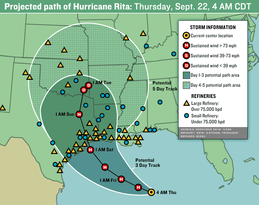
112. Not good...and check this out mapped against refineries

Printer Friendly | Permalink |  | Top
 
BrightKnight Donating Member (1000+ posts) Send PM | Profile | Ignore Thu Sep-22-05 01:39 AM
Response to Reply #112
119. Losing another major ports would case problems. -- n/t
Printer Friendly | Permalink |  | Top
 
tammywammy Donating Member (1000+ posts) Send PM | Profile | Ignore Thu Sep-22-05 03:53 PM
Response to Reply #119
145. Being a little selfish right now
My car is currently being put together in Mexico (A VW Beetle TDI). Volkswagen uses Houston as their port, so I'm hoping that the port isn't messed up too much. The car is supposed to be delivered to the dealership the 1st week of November, so hopefully it's not delayed too much.
Printer Friendly | Permalink |  | Top
 
Kurovski Donating Member (1000+ posts) Send PM | Profile | Ignore Wed Sep-21-05 11:36 PM
Response to Original message
111. I just heard that it is 300 MILES WIDE.
from meteorologist on CNN.
Printer Friendly | Permalink |  | Top
 
progressivebydesign Donating Member (1000+ posts) Send PM | Profile | Ignore Thu Sep-22-05 12:10 AM
Response to Reply #111
113. What does that mean in regard to area of damage at full intensity?
Does that wideness indicate that it will be equally strong at that width? Or is there more instense bands toward the center. My brother lives 200 miles north of the projected landfall center... and I know nothing about hurricanes.
Printer Friendly | Permalink |  | Top
 
Kurovski Donating Member (1000+ posts) Send PM | Profile | Ignore Thu Sep-22-05 12:46 AM
Response to Reply #113
114. Oh lord, she didn't go into that. She said it was 300 miles
at the time. I don't know about at landfall. Do hurricanes usually reduce in area by landfall? Someone here who can answer that?

I have also heard that there is cooler water in Rita's path that will possibly reduce its stength.

progressivebydesign, do you want to start a thread asking these questions of folks who know about hurricanes?

It could be of interest to a wide range of DUers.


Printer Friendly | Permalink |  | Top
 
Kurovski Donating Member (1000+ posts) Send PM | Profile | Ignore Thu Sep-22-05 01:05 AM
Response to Reply #113
117. But I would think that anyone 200 miles north would still have
Edited on Thu Sep-22-05 01:23 AM by Kurovski
a 50 mile buffer, if you consider the hurricane would be 150 miles from its center as it hit land.

Hurricanes dwindle into smaller storms a they travel landward, do they not? You might want to look at post#99 by baclava.

Anyone?
Printer Friendly | Permalink |  | Top
 
JCMach1 Donating Member (1000+ posts) Send PM | Profile | Ignore Thu Sep-22-05 03:48 AM
Response to Original message
120. Hurricane RITA Update (6:50 PM, NHC, Third Strongest Storm on Record)
Edited on Thu Sep-22-05 12:37 AM by JCMach1
WTNT63 KNHC 212351
TCUAT3
HURRICANE RITA TROPICAL CYCLONE UPDATE
NWS TPC/NATIONAL HURRICANE CENTER MIAMI FL
650 PM CDT WED SEP 21 2005

...RITA BECOMES THE THIRD MOST INTENSE HURRICANE ON RECORD...

DROPSONDE DATA FROM AN AIR FORCE RESERVE UNIT RECONNAISSANCE
AIRCRAFT AT 623 PM CDT...2323Z...INDICATED THE CENTRAL PRESSURE HAS
FALLEN TO BELOW 899 MB...OR 26.55 INCHES. THE DROPSONDE INSTRUMENT
MEASURED 32 KT/35 MPH WINDS AT THE SURFACE...WHICH MEANS IT LIKELY
DID NOT RECORD THE LOWEST PRESSURE IN THE EYE OF RITA. THE CENTRAL
PRESSURE IS PROBABLY AT LEAST AS LOW AS 898 MB...AND PERHAPS EVEN
LOWER. FOR OFFICIAL PURPOSES... A PRESSURE OF 898 MB IS ASSUMED...
WHICH NOW MAKES RITA THE THIRD MOST INTENSE HURRICANE IN TERMS OF
PRESSURE IN THE ATLANTIC BASIN. SOME ADDITIONAL DEEPENING AND
INTENSIFICATION IS POSSIBLE FOR THE NEXT 12 HOURS OR SO.

RITA CURRENTLY RANKS BEHIND HURRICANE GILBERT IN 1988 WITH 888 MB
AND THE 1935 LABOR DAY HURRICANE WITH 892 MB.

FORECASTER STEWART

http://www.nhc.noaa.gov/text/refresh/MIATCUAT3+shtml/212351.shtml

also link to 11:00 advisory

http://www.nhc.noaa.gov/text/refresh/MIATCPAT3+shtml/220249.shtml

ALSO, from the Weather Channel

Hurricane Rita's rapid intensification cycle that began Tuesday afternoon continues. Top winds are up to 175 mph, now a category 5 hurricane. Rita's pressure has dramatically dropped to 897 millibars! Even as a large and extremely intense category 5 hurricane, further strengthening is possible as the atmosphere remains favorable for development over the next 24 hours.

Rita is forecast to continue on a westward track through the Gulf of Mexico over the next 24 hours. A gradual turn toward the northwest is anticipated Thursday night and Friday. If there is any good news at this point, it is the fact that it is very difficult for a hurricane to maintain category 5 status for an lengthy period of time. Near-perfect to perfect atmospheric conditions are necessary for a category 5 hurricane to exist and these "perfect" conditions are first - difficult to come by and second - do not remain in place for a long period of time. So although Rita is currently a category 5 hurricane, fluctuations in intensity is likely. That being said, it is almost a certainty that Rita will make landfall as a large, intense, major hurricane with impacts extending well away from the center. Hurricane force winds extend 70 miles away from the center and tropical storm force winds extend 175 miles from the center. Landfall is possible late Friday or early Saturday along the Texas coast. Residents and tourists in locations such as Corpus Christi, Aransas Pass, San Jose Island, Matagorda Island, Port Lavaca, Port O'Connor, Bay City, Lake Jackson, Freeport, Galveston, Texas City, Houston, and Port Author should ALL prepare for a very dangerous landfalling major hurricane.... http://www.weather.com/newscenter/tropical/?from=wxcenter_news
Printer Friendly | Permalink |  | Top
 
BeHereNow Donating Member (1000+ posts) Send PM | Profile | Ignore Thu Sep-22-05 03:48 AM
Response to Reply #120
121. How frightening is this?
I swear, I am terrified for the people
in its path.
Worried sick about my brother.
He flies copters for the platform workers
on the gulf- they are moving choppers right now.
Hope he is safe...
BHN
Printer Friendly | Permalink |  | Top
 
JCMach1 Donating Member (1000+ posts) Send PM | Profile | Ignore Thu Sep-22-05 03:48 AM
Response to Reply #120
122. A very deadly storm unless it changes path
I am still hoping it heads for a sparsely populated area of texas or la
Printer Friendly | Permalink |  | Top
 
grahamhgreen Donating Member (1000+ posts) Send PM | Profile | Ignore Thu Sep-22-05 03:48 AM
Response to Reply #120
123. Headed straight for CRAWFORD!
Is God talking to George Again?
Printer Friendly | Permalink |  | Top
 
Roland99 Donating Member (1000+ posts) Send PM | Profile | Ignore Thu Sep-22-05 10:04 AM
Response to Original message
124. Weakening a bit...170mph winds...907mb pressure
8AM Eastern update


MAXIMUM SUSTAINED WINDS ARE ESTIMATED NEAR 170 MPH WITH HIGHER
GUSTS. THIS MAKES RITA A POTENTIALLY CATASTROPHIC CATEGORY
FIVE HURRICANE ON THE SAFFIR-SIMPSON SCALE. A SLOW WEAKENING TREND
IS FORECAST BUT RITA IS EXPECTED TO REACH THE COAST LATE FRIDAY OR
EARLY SATURDAY AS A MAJOR HURRICANE...AT LEAST CATEGORY THREE.

HURRICANE FORCE WINDS EXTEND OUTWARD UP TO 70 MILES FROM THE
CENTER...AND TROPICAL STORM FORCE WINDS EXTEND OUTWARD UP
TO 185 MILES.

THE LATEST MINIMUM CENTRAL PRESSURE RECENTLY MEASURED BY A HURRICANE
HUNTER AIRCRAFT WAS 907 MB...26.78 INCHES.
Printer Friendly | Permalink |  | Top
 
Roland99 Donating Member (1000+ posts) Send PM | Profile | Ignore Thu Sep-22-05 10:27 AM
Response to Original message
125. 11AM Eastern Update - Further weakening and moving further up the coast
Edited on Thu Sep-22-05 10:27 AM by Roland99
11AM Eastern update

AT 10 AM CDT...1500Z...THE EYE OF HURRICANE RITA WAS LOCATED NEAR
LATITUDE 25.4 NORTH...LONGITUDE 88.7 WEST OR ABOUT 460 MILES...740
KM...SOUTHEAST OF GALVESTON TEXAS AND ABOUT 445 MILES...715 KM...
SOUTHEAST OF PORT ARTHUR TEXAS.

RITA IS MOVING TOWARD THE WEST-NORTHWEST NEAR 9 MPH...15 KM/HR. A
GRADUAL TURN TO THE NORTHWEST IS EXPECTED DURING THE NEXT 24 TO 36
HOURS.

MAXIMUM SUSTAINED WINDS HAVE DECREASED TO NEAR 165 MPH...270
KM/HR... WITH HIGHER GUSTS. RITA IS A CATEGORY FIVE HURRICANE ON
THE SAFFIR-SIMPSON SCALE. SOME SLIGHT WEAKENING IS FORECAST DURING
THE NEXT 24 HOURS BUT RITA IS EXPECTED TO REMAIN AN EXTREMELY
DANGEROUS HURRICANE.

HURRICANE FORCE WINDS EXTEND OUTWARD UP TO 85 MILES...140 KM...
FROM THE CENTER...AND TROPICAL STORM FORCE WINDS EXTEND OUTWARD UP
TO 185 MILES...295 KM.

ESTIMATED MINIMUM CENTRAL PRESSURE IS 907 MB...26.78 INCHES.

COASTAL STORM SURGE FLOODING OF 15 TO 20 FEET ABOVE NORMAL TIDE
LEVELS...ALONG WITH LARGE AND DANGEROUS BATTERING WAVES...CAN BE
EXPECTED NEAR AND TO THE RIGHT OF WHERE THE CENTER MAKES LANDFALL.
TIDES ARE CURRENTLY RUNNING ABOUT 1 FOOT ABOVE NORMAL ALONG THE
MISSISSIPPI AND LOUISIANA COASTS IN THE AREAS AFFECTED BY KATRINA.
TIDES IN THOSE AREAS WILL INCREASE UP TO 3 TO 4 FEET AND BE
ACCOMPANIED BY LARGE WAVES...AND RESIDENTS THERE COULD EXPERIENCE
SOME COASTAL FLOODING.

RAINFALL ACCUMULATIONS OF 8 TO 12 INCHES WITH ISOLATED MAXIMUM 15
INCH TOTAL ARE POSSIBLE ALONG THE PATH OF RITA PARTICULARLY OVER
SOUTHEAST TEXAS AND WESTERN LOUISIANA. IN ADDITION...RAINFALL
AMOUNTS OF 3 TO 5 INCHES ARE POSSIBLE OVER SOUTHEASTERN LOUISIANA
INCLUDING NEW ORLEANS. BASED ON THE FORECAST TRACK...RAINFALL
TOTALS IN EXCESS OF 25 INCHES ARE POSSIBLE AFTER RITA MOVES INLAND.


A bit more weakening of the winds but the pressure is holding.


Updated 3-day projection cone
http://www.nhc.noaa.gov/refresh/graphics_at3+shtml/145647.shtml?3day?large

SW LA in more danger now.
Printer Friendly | Permalink |  | Top
 
obreaslan Donating Member (1000+ posts) Send PM | Profile | Ignore Thu Sep-22-05 10:58 AM
Response to Reply #125
128. I guess that's the eye collapsing on itself....
THey mentioned that would happen. Now we'll have to see if it strengthens again before landfall. I hope not. :scared:

Printer Friendly | Permalink |  | Top
 
Roland99 Donating Member (1000+ posts) Send PM | Profile | Ignore Thu Sep-22-05 11:22 AM
Response to Reply #128
130. I thought it was but not heard mention of an eyewall replacement
Given its distance out, I wouldn't be surprised to see another before landfall.
Printer Friendly | Permalink |  | Top
 
Baclava Donating Member (1000+ posts) Send PM | Profile | Ignore Thu Sep-22-05 11:32 AM
Response to Reply #125
132. Yep - tracks have shifted right...
Edited on Thu Sep-22-05 11:39 AM by Baclava
To the north and right side of the Bay near Galveston. And may shift again, either way. It is going to head more north than expected.

That's why you can't trust the dotted line...

Look at the cone, the cone, the cone...!!!

I'm afraid that there are still folks living deep within the storm surge areas of coastal Tx/La who don't realize the danger. As usual, the news channels are focusing on the big cities like Houston...


Rita could now very easliy hit near the Texas/Louisiana border, east of the Galveston/Houston area; however, hurricane force winds could occur up to roughly 100 miles from the center.

Printer Friendly | Permalink |  | Top
 
papau Donating Member (1000+ posts) Send PM | Profile | Ignore Thu Sep-22-05 11:45 AM
Response to Original message
133. Friday 11 am EST update for RITA
Edited on Thu Sep-22-05 10:24 AM by papau
http://www.nhc.noaa.gov/storm_graphics/AT18/refresh/AL1805I_sm2+gif/145647P_sm.gif

http://www.nhc.noaa.gov/storm_graphics/AT18/refresh/AL1805P_sm2+gif/145647P_sm.gif

http://www.nhc.noaa.gov/text/refresh/MIATCDAT3+shtml/221455.shtml?

000
WTNT43 KNHC 221455
TCDAT3
HURRICANE RITA DISCUSSION NUMBER 20
NWS TPC/NATIONAL HURRICANE CENTER MIAMI FL
11 AM EDT THU SEP 22 2005

RITA APPEARS TO HAVE REACHED ITS PEAK INTENSITY DURING THE PAST
12 HOURS. HURRICANES TYPICALLY DO NOT MAINTAIN SUCH HIGH INTENSITY
FOR A LONG TIME. INITIAL INTENSITY ESTIMATE IS 145 KNOTS. ALTHOUGH
SOME FLUCTUATIONS IN INTENSITY ARE LIKELY DURING THE NEXT DAY OR
TWO...DUE TO EYEWALL REPLACEMENT CYCLES...AN OVERALL GRADUAL
WEAKENING TREND SHOULD TAKE PLACE. THIS WEAKENING TREND IS BASED ON
LOWER OCEANIC HEAT CONTENT ALONG THE FORECAST TRACK AND INCREASING
SHEAR. NEVERTHERELESS...RITA IS EXPECTED TO MAKE LANDFALL AS A
DANGEROUS HURRICANE OF AT LEAST A CATEGORY THREE INTENSITY.

RITA HAS BEEN MOVING TOWARD THE WEST-NORTHWEST OR 295 DEGREES AT 8
KNOTS. A STRONG HIGH PRESSURE SYSTEM CURRENTLY CENTERED OVER
NORTHERN TEXAS/OKLAHOMA IS EXPECTED TO SHIFT EASTWARD ALLOWING RITA
TO TAKE A MORE NORTHWESTERLY AND NORTHERLY TRACK. THE EASTWARD
SHIFT OF THE HIGH IS FORECAST BY ALL GLOBAL MODELS...RESULTING IN
TRACK GUIDANCE CONSISTENTLY TURNING THE HURRICANE TOWARD THE
NORTHWEST AND NORTH TOWARD THE UPPER-TEXAS OR THE WESTERN LOUISIANA
COASTS. AFTER LANDFALL...STEERING CURRENTS ARE EXPECTED TO WEAKEN
AND THE CYCLONE COULD MEANDER FOR A COUPLE OF DAYS IN THE VICINITY
OF NORTHEASTERN TEXAS...PRODUCING HEAVY RAINS.

BASED ON THE FORECAST TRACK AND WIND RADII...HURRICANE WARNINGS HAVE
BEEN ISSUED AT THIS TIME FROM PORT O'CONNOR TEXAS TO MORGAN CITY
LOUISIANA. TROPICAL STORM WARNINGS ARE IN EFFECT ON EITHER SIDE OF
THE HURRICANE WARNING.

FORECASTER AVILA

FORECAST POSITIONS AND MAX WINDS

INITIAL 22/1500Z 25.4N 88.7W 145 KT
12HR VT 23/0000Z 25.8N 89.9W 140 KT
24HR VT 23/1200Z 26.9N 91.6W 130 KT
36HR VT 24/0000Z 28.2N 93.0W 125 KT
48HR VT 24/1200Z 30.0N 94.5W 100 KT...INLAND
72HR VT 25/1200Z 33.0N 95.0W 45 KT...INLAND
96HR VT 26/1200Z 34.0N 95.0W 30 KT...INLAND
120HR VT 27/1200Z 34.5N 94.5W 25 KT...INLAND


http://www.cnn.com/2005/US/09/22/news.update.thurs/

Printer Friendly | Permalink |  | Top
 
Chico Man Donating Member (1000+ posts) Send PM | Profile | Ignore Thu Sep-22-05 11:45 AM
Response to Reply #133
134. "Better" news
Lets hope the trend continues.
Printer Friendly | Permalink |  | Top
 
papau Donating Member (1000+ posts) Send PM | Profile | Ignore Thu Sep-22-05 11:45 AM
Response to Reply #134
135. Possible landfall as a Cat 3 just West of Lou Border- but as it is getting
closer to NO, the rainfall may be too much for the city?

Hard to see a "good" ending.
Printer Friendly | Permalink |  | Top
 
sabbat hunter Donating Member (1000+ posts) Send PM | Profile | Ignore Thu Sep-22-05 11:45 AM
Response to Reply #135
136. closer to Louisana
the worse it is for NO. the most powerful side of a hurricane is the eastern quadrant. a landing in western louisiana would slam NO with new flooding rains, winds and tidal surge.

Printer Friendly | Permalink |  | Top
 
papau Donating Member (1000+ posts) Send PM | Profile | Ignore Thu Sep-22-05 12:05 PM
Response to Reply #136
137. True - and it will not take much to re-flood NO :-(
:-(
Printer Friendly | Permalink |  | Top
 
Baclava Donating Member (1000+ posts) Send PM | Profile | Ignore Thu Sep-22-05 12:36 PM
Response to Reply #134
140. 1915 - only year with two CAT 4 landfalls in U.S.
Aug 17 - Galveston
Sept 29 - New Orleans

TWC factoid...eerie...
Printer Friendly | Permalink |  | Top
 
Name removed Donating Member (0 posts) Send PM | Profile | Ignore Thu Sep-22-05 12:39 PM
Response to Reply #140
141. Deleted message
Message removed by moderator. Click here to review the message board rules.
 
Baclava Donating Member (1000+ posts) Send PM | Profile | Ignore Thu Sep-22-05 01:05 PM
Response to Reply #141
142. Facts are facts...
...and shit happens...hurricanes are not new. If we had a 1000 year view of their cycles...we would probably have a better idea of their frequency and strength...but we don't, and that goes the same for global climate change. You deal with what you know.
Printer Friendly | Permalink |  | Top
 
Barrett808 Donating Member (1000+ posts) Send PM | Profile | Ignore Thu Sep-22-05 01:08 PM
Response to Reply #141
143. Welcome to DU, RPM_BU!
:hi:
Printer Friendly | Permalink |  | Top
 
Peace Patriot Donating Member (1000+ posts) Send PM | Profile | Ignore Thu Sep-22-05 12:12 PM
Response to Original message
138. I'm no global warming expert, but I try to keep up with the news in bits
and pieces here and there, and it's my understanding that ocean temperatures are rising at an alarming rate, that an average rise of only a couple of degrees is highly significant, that there are new dead spots in the oceans, major fish die-offs and losses of fisheries, and strange phenomena--seabird die-offs (North Sea) and unusual migration pattern changes-- and that global warming models predicted intensified hurricanes with high impacts and flooding on coastal areas--just what is happening on the Gulf coast.

When you look at what our species has done to the planet over the last 100 years--80% loss of primary forest, enormous losses of species diversity, great urbanization and loss of vegetation, and massive infusions of pollutants into air, fresh waters and oceans--it seems a no-brainer that the delicate balance of nature--water, air, plants, animals--WOULD BE profoundly affected.

Then there are the polar ice caps and glaciers melting. Given the prediction of an ice age, this may mean that the impact of our industrialization is much bigger than we realize--not just warming the planet but is PREVENTING an ice age.

-------

What is most alarming of all is that the United States is NOT DOING ANYTHING ABOUT IT--and is being run by global corporate predators who are using war and other means to corner the last natural resources, and to insulate the super-rich from the impacts, in a system of industrialization that is destroying our planet, our only known home!

And, in that respect, I would say the following:

We need to throw Diebold and ES&S election theft machines into 'Boston Harbor'--or the nearest Louisiana levee, or the floodwaters of Houston!

We need TRANSPARENT, VERIFIABLE ELECTIONS, and that means:


1. Paper ballots hand-counted at the precinct level (--Canada does it in one day, although speed should not even be a consideration, just accuracy and verifiability)

or, at the least...

2. Paper ballot (not "paper trail") backup of all electronic voting, a 10% automatic recount, very strict security, and NO SECRET, PROPRIETARY programming code! (...jeez!).


And we need it NOW! There is almost no time left to address global warming. We need a VISIONARY PRESIDENT NOW--who can get us off oil and onto alternative fuels, and who can convene an international crisis meeting to address the threat to our planet. U.S. consumers and U.S.-based global corporate predators are the worst offenders! But we can also help turn this around, because we're so big!

Currently, these 2 Bushite election theft corporations--Diebold and ES&S--are controlling our election outcomes, with SECRET, PROPRIETARY programming code used to "tabulate" all our votes, and they will continue to give us catastrophically bad leadership, if we don't act to stop them.

And there is bipartisan corruption among election officials, with even Democrats agreeing to--or remaining silent about--this new fraudulent election SYSTEM. We have to throw these people out of office, however we can, and start over--with transparent, verifiable elections of one kind or another.
Printer Friendly | Permalink |  | Top
 
Roland99 Donating Member (1000+ posts) Send PM | Profile | Ignore Thu Sep-22-05 05:06 PM
Response to Original message
146. 5PM Eastern update...further weakening...ending an ERC?
AT 4 PM CDT...2100Z...THE CENTER OF HURRICANE RITA WAS LOCATED NEAR
LATITUDE 25.8 NORTH...LONGITUDE 89.5 WEST OR ABOUT 405 MILES...
650 KM...SOUTHEAST OF GALVESTON TEXAS AND ABOUT 390 MILES... 630
KM...SOUTHEAST OF PORT ARTHUR TEXAS.

RITA IS MOVING TOWARD THE WEST-NORTHWEST NEAR 9 MPH...15 KM/HR. A
GRADUAL TURN TOWARD THE NORTHWEST IS EXPECTED DURING THE NEXT 24
HOURS. ON THIS TRACK...THE CORE OF RITA WILL BE APPROACHING THE
SOUTHWEST LOUISIANA AND THE UPPER TEXAS COAST LATE FRIDAY.

MAXIMUM SUSTAINED WINDS ARE NEAR 145 MPH...230 KM/HR...WITH HIGHER
GUSTS. RITA IS A EXTREMELY DANGEROUS CATEGORY FOUR HURRICANE ON THE
SAFFIR-SIMPSON SCALE. SOME FLUCTUATIONS IN INTENSITY ARE LIKELY
DURING THE NEXT 24 HOURS.

HURRICANE FORCE WINDS EXTEND OUTWARD UP TO 60 MILES... 95 KM...
FROM THE CENTER...AND TROPICAL STORM FORCE WINDS EXTEND OUTWARD UP
TO 205 MILES...335 KM. ANYTROPICAL STROM FORCE WINDS IN THE NEW
ORLEANS AREA ARE EXPECTED TO BE CONFINED TO A FEW SQUALLS
ASSOCIATED WITH QUICKLY MOVING RAINBANDS. AT 3 PM CDT...A NOAA BUOY
REPORTED A 10-MINUTE AVERAGE WIND OF 89 MPH...143 KM/HR WITH A GUST
TO 112 MPH...180 KM/HR.

LATEST MINIMUM CENTRAL PRESSURE REPORTED BY AN AIR FORCE PLANE WAS
913 MB...26.96 INCHES.


http://www.nhc.noaa.gov/refresh/graphics_at3+shtml/204626.shtml?3day?large

Shifting further up the coast. Houston in the clear, relatively speaking?


Looks like an ERC is ending and there's some shear on the far northern side (from that high-pressure above)?

I'm no meteorologist but something tells me this time tomorrow, she'll be back to near Cat 5 strength.
Printer Friendly | Permalink |  | Top
 
Roland99 Donating Member (1000+ posts) Send PM | Profile | Ignore Thu Sep-22-05 06:15 PM
Response to Reply #146
150. Ayup...looks like we have a new, nicely-formed eye
http://www.ssd.noaa.gov/PS/TROP/DATA/RT/float-vis-loop.html

And it's on a more northerly path? :scared:
Printer Friendly | Permalink |  | Top
 
Roland99 Donating Member (1000+ posts) Send PM | Profile | Ignore Thu Sep-22-05 07:05 PM
Response to Reply #150
152. She's a growin'
Printer Friendly | Permalink |  | Top
 
martymar64 Donating Member (1000+ posts) Send PM | Profile | Ignore Thu Sep-22-05 08:10 PM
Response to Original message
153. Traffic is crazy in Austin tonight
I live about 2 miles from the Austin evac center and people are streaming in now. I've heard it's been taking 10 - 13 hours to get from Houston to Austin (about 150 miles)
Printer Friendly | Permalink |  | Top
 
DU AdBot (1000+ posts) Click to send private message to this author Click to view 
this author's profile Click to add 
this author to your buddy list Click to add 
this author to your Ignore list Fri Apr 26th 2024, 07:36 PM
Response to Original message
Advertisements [?]
 Top

Home » Discuss » Latest Breaking News Donate to DU

Powered by DCForum+ Version 1.1 Copyright 1997-2002 DCScripts.com
Software has been extensively modified by the DU administrators


Important Notices: By participating on this discussion board, visitors agree to abide by the rules outlined on our Rules page. Messages posted on the Democratic Underground Discussion Forums are the opinions of the individuals who post them, and do not necessarily represent the opinions of Democratic Underground, LLC.

Home  |  Discussion Forums  |  Journals |  Store  |  Donate

About DU  |  Contact Us  |  Privacy Policy

Got a message for Democratic Underground? Click here to send us a message.

© 2001 - 2011 Democratic Underground, LLC