Eyewitness Confirms Shootdown of Flight 93 on Stern today
Howard Stern Show | April 21 2004
A caller to the Howard Stern Show related the story of how he saw Flight 93 in flames while it was in the air and two other aircraft circling it.
listen here
http://www.prisonplanet.com/articles/april2004/042104flight93.htm Red_Viking (468 posts) Wed Apr-21-04 01:12 PM
Response to Reply #1
11. The pilots are "unavailable"
No joke--all the pilots scrambled on 9/11 were sequestered and no one has spoken to them. Wouldn't they be the best ones to answer these questions?
This came out during the 9/11 Commission questioning of NORAD officials. They said the pilots were unavailable for questioning. I said, "huh?"
Also, foreign news sources did a lot of reporting on the condition of the crash site. Very peculiar. Wreckage was scattered up to 8 miles away. Not consistent with a plane hitting the ground, where wreckage would be fairly linear. This stuff was blown all the heck over the place, kinda like the plane was blown out of the sky.
Makes me say hmmmmmm.
By the way, it is legal for them to do this. I'm not sure why no one will admit the plane was ordered shot down. The plane was hijacked. I suppose it's because the shock would be too much.
Must_B_Free
16. It was on the Johnstown PA TV news
early that day till it got scrubbed. They aired footage of an interview with a farmer that corroberates this account. He said "I saw the big plane and them other little planes by it"
Bjornsdotter (19 posts) Wed Apr-21-04 12:48 PM
Response to Original message
5. Too True!
Hi,
Two days after Flight 93 was shot down, I received a call from a business aquaintance...he told me he saw it shot down. He has since left the country.
Later in the week I spoke with a air traffic controller at O'Hare...he told me "No Comment" when I asked if the plane was shot down.
I do believe it was shot down...for those of you who don't....ask yourself one question; Why has there NEVER been a photo published showing the crash site?
Cheers,
Kim
LisaM (1000+ posts) Wed Apr-21-04 02:57 PM
Response to Original message
13. Strange. Interesting.
Edited on Wed Apr-21-04 03:26 PM by LisaM
Just last night, I accidentally listened to KVI (local hate radio station) for several minutes and the played a transcript of the ATC talking to Flight 93 (it was edited so that it played through in four minutes, so either some parts were classified, or they just edited out the dead air.) Anyway, there was a part right near the end where an air traffic controller confirmed from a pilot on another flight that there was smoke on it, and it also appeared that other flights were trying to keep it in their sights.
No2W2004 (122 posts) Wed Apr-21-04 03:07 PM
Response to Reply #13
14. Right
Brave Americans fighting their captors is much better for propaganda than Air Force shoots down commercial airliner.
I still remember hearing on 9/11 witnesses saying the plane was shot down, then, in the following days, they all stopped talking and the heroic version took root.
Has anyone ever explained why one engine of flight 93 was found miles away from the crash site?
rhino47 (292 posts) Thu Apr-22-04 01:27 AM
Response to Original message
24. I live in western Pa
I saw that flight that day.I know that it was flight 93.My nephew is an air traffic controller out of youngstown ohio.On 9/11 when I heard that the skies where cleared and I saw that jet I was rather frightened being where as it started towards cleveland and came back around southeast.I did see two planes shortly there after.I called my nephew but the lines where all done.I got the all circuits are busy.I did manage to get a hold of him later on that day about 6 pm .He said that flight had went down near pittsburg.
http://www.democraticunderground.com/discuss/duboard.php?az=show_topic&forum=104&topic_id=1449593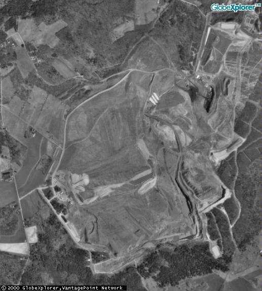
Here's an aerial view of the whole strip mine where Flight 93 crashed.
Here's the deal: after following the links below, the real crash
location of Flight 93 is a couple hundred yards away from Skyline Road
near Lambertsville and Shanksville. I had to find it by finding
Lambertsville, PA on the map, then go south. Lambertsville Road in the
photo is on the far left. Then Skyline Road forks down in a southeast
direction in the mine area. Now somewhere in that area, you'd mark an X
to mark the crash site. Keep in mind this photo is 2 levels out: more
detail could be retrieved, BUT bear in mind this photo has to be OLD
because it's in black and white. So it's before the crash happened,
see.
The deal with the mine itself is: a company called Svonavec owns the
area where the mine is, and they LEASE it to both Rollock Inc. and PBS
Coals Inc.
Religious folks are heavily leaning on that LAMBertsville name, meaning
the Lord did it to prove this and that, something or other...
Does that help? Sheesh! Just try to find an overhead satellite photo
of the Flight 93 crash, and it's like pulling TEETH! But now you got
the photo, Kent. I'm done for tonight... Happy Thanksgiving!
http://www.cyberspaceorbit.com/warrant25.htm
Seismographs of the sonic boom, recorded at approximately 9:22 AM local time on 9/11
The presence of this particular sonic boom at 9:22 A.M. refutes the story we have been told of the military's response to 9/11.
The North American Aerospace Defense Command, or NORAD, issued a press release one week after the attacks. The timeline told of Air National Guard fighter jets taking off from bases in Massachusetts and Virginia at 8:46 A.M. and 9:30 A.M., respectively. The first jets, two F-15's from Otis Air National Guard Base, responded to an 8:40 A.M. scramble order and screamed towards New York City six minutes later. The second group, F-16's from Langley AFB, responded to a 9:24 A.M. order and again were en route to their target in six minutes, this time pointing towards Washington D.C. and the threatened Pentagon.
The problem with this story is that neither group of fighters could have made the sonic boom recorded in Pennsylvania by 9:22.
The F-16's from Langley hadn't even been told to get into the air yet, so they're out. The F-15's from Otis reached New York at 9:06, 3 minutes too late to stop the second World Trade Center impact, having averaged a speed of around 800 miles per hour to get there. They could have covered the 207 miles from NYC to the seismic station in Pennsylvania in a mere 15 minutes at that speed. But this would have required them to leave New York City undefended at 9:07, merely one minute after arriving.
It would also have required a sixth sense, since the FAA didn't even warn NORAD that Flight 93 was considered a possible threat until 9:16.
While we don't know where the jet that created the sonic boom came from, we can safely assume that any aircraft moving supersonically over the continental U.S. by 9:22 on September 11th was part of our own military. And not knowing the fighter's home base does little to change the fact that it would have been in excellent position to intercept Flight 93 well before it crashed at 10:06.
Major General Paul A. Weaver Jr., Director of the Air National Guard, has told reporters that National Guard aircraft "weren't even close" to the fourth hijacked airliner. Thanks to the seismic record, we can now suggest there was little gold in his remarks.
Tracking aircraft in flight with seismic networks is not a new idea. NASA has looked at ground-recorded sonic boom signatures of aircraft like the F-18 and the SR-71; scientists at the California Institute of Technology have examined data from existing networks for events like the landing of the space shuttle Discovery.
Seismic networks have also been used to determine the time of aircraft crashes; indeed, when the United States Army wanted to know with greater accuracy exactly when Flight 77 struck the Pentagon on 9/11, they turned to seismologists at the Lamont-Doherty Earth Observatory at Columbia University, and the Maryland Geological Survey. Won-Young Kim and Gerald R. Baum were unable to definitively set the impact time of the Pentagon crash, but they were able to determine the time of Flight 93's impact to within 5 seconds (10:06:05 ±5, EDT).
In the days and weeks following the crash, rumors circulated of a shoot-down, the scenario being that the military brought the airliner down before it could reach a more populated area. It should be said that just because we now know a fighter was close enough to do the grim job, it doesn't necessarily follow that the job was done: there is still no direct proof that the unknown fighter chose to fire upon Flight 93.
The question, however, remains:
Why would NORAD misrepresent where their fighters were if they didn't shoot it down?
http://www.flight93crash.com/flight93_seismic_event.htmCatching the FBI in a Big Fat Lie

The Pennsylvania Department of Environmental Protection released this photo a few days later
The pattern of impact is consistent with an aircraft with significant lateral movement,
a "fan" pattern where debris is blown in the direction the aircraft was headed.
Debris found two and eight miles from the crash was explained by this "splatter" effect, bolstered by
winds reported in the area at the time. The effect of the wind can be seen in the burned trees as well.
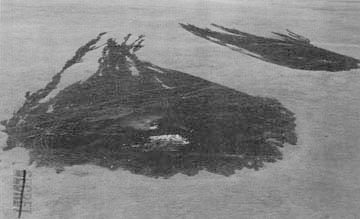
The grass in this farmer's field is similar to that replanted in stripmine reclamation projects.
Windspeed at the time of this accident was recorded as 15 knots. As you can see, fire from the
wreckage was spread through the grass by the wind. You can clearly determine the direction
of the wind by the way the fire spread. Just like the FBI and PDEP photos.
Except....
This showed two important things. First, that the impact indeed occured on the border between
flammable grassland and equally flammable forest.
Second, and much more importantly, it showed me which way was north.
Something the other photos oddly enough didn't bother to indicate.
http://www.bartcop.com/flight93.htm


 *bobthedrummer


 *
*


