| Latest | Greatest | Lobby | Journals | Search | Options | Help | Login |
|
|
|
This topic is archived. |
| Home » Discuss » Archives » General Discussion (Through 2005) |
|
| eleny
|
Tue Aug-16-05 07:37 PM Original message |
| Google Map of the new Camp Casey? |
| Printer Friendly | Permalink | | Top |
| wakeme2008
|
Tue Aug-16-05 07:40 PM Response to Original message |
| 1. If you can get a positive link |
| Printer Friendly | Permalink | | Top |
| eleny
|
Tue Aug-16-05 07:42 PM Response to Reply #1 |
| 2. P.S. |
| Printer Friendly | Permalink | | Top |
| Bush_Eats_Beef
|
Tue Aug-16-05 07:43 PM Response to Original message |
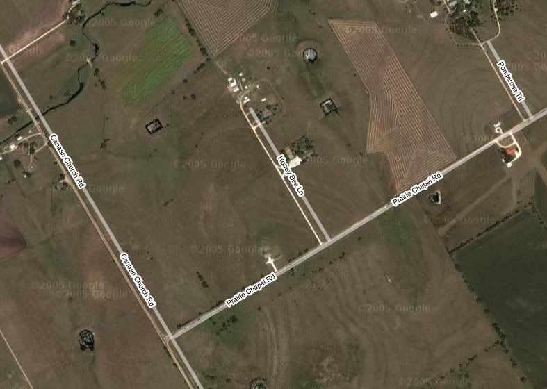
| 3. But I can post a jpg...thanks to SnagIt. |
| Printer Friendly | Permalink | | Top |
| Generic Other
|
Tue Aug-16-05 07:46 PM Response to Reply #3 |
| 5. What's the arrow pointing at? Bush on his bike? |
| Printer Friendly | Permalink | | Top |
| Bush_Eats_Beef
|
Tue Aug-16-05 07:47 PM Response to Reply #5 |
| 6. I fixed the pic...the arrow was my cursor. |
| Printer Friendly | Permalink | | Top |
| eleny
|
Tue Aug-16-05 07:55 PM Response to Reply #3 |
| 7. You need to do some things to locate the church |
| Printer Friendly | Permalink | | Top |
| Generic Other
|
Tue Aug-16-05 07:44 PM Response to Original message |
| 4. Where's Crazy Larry's house and the triangle of grass on |
| Printer Friendly | Permalink | | Top |
| achtung_circus
|
Tue Aug-16-05 08:05 PM Response to Reply #4 |
| 10. Here. |
| Printer Friendly | Permalink | | Top |
| Generic Other
|
Tue Aug-16-05 08:20 PM Response to Reply #10 |
| 13. Thanks |
| Printer Friendly | Permalink | | Top |
| achtung_circus
|
Tue Aug-16-05 08:03 PM Response to Original message |
| 8. Here're some links. |
| Printer Friendly | Permalink | | Top |
| Duer 157099
|
Tue Aug-16-05 08:04 PM Response to Original message |
| 9. Is the church the place where the cross on the map is? |
| Printer Friendly | Permalink | | Top |
| Duer 157099
|
Tue Aug-16-05 08:11 PM Response to Original message |
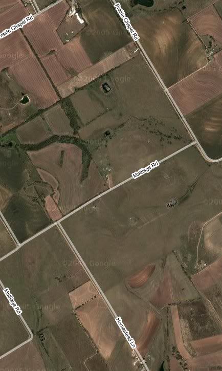
| 11. Notice the road named "Mattlage" |
| Printer Friendly | Permalink | | Top |
| darkism
|
Wed Aug-17-05 01:09 AM Response to Reply #11 |
| 23. haha I was just about to say something about that |
| Printer Friendly | Permalink | | Top |
| Duer 157099
|
Tue Aug-16-05 08:13 PM Response to Original message |
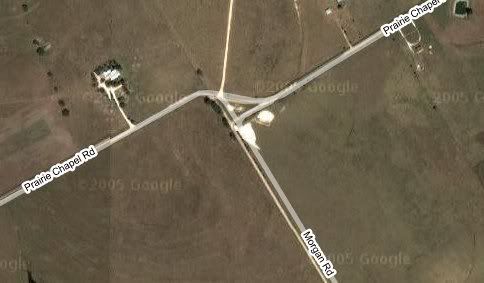
| 12. Is this "the" triangle? |
| Printer Friendly | Permalink | | Top |
| eleny
|
Tue Aug-16-05 08:29 PM Response to Reply #12 |
| 15. It's the only one anywhere near town |
| Printer Friendly | Permalink | | Top |
| BeTheChange
|
Wed Aug-17-05 02:20 AM Response to Reply #12 |
| 26. That sure looks like it... |
| Printer Friendly | Permalink | | Top |
| eleny
|
Tue Aug-16-05 08:27 PM Response to Original message |
| 14. Okay - Here's the map with W's place and the 2 church locations |
| Printer Friendly | Permalink | | Top |
| Duer 157099
|
Tue Aug-16-05 08:48 PM Response to Reply #14 |
| 16. So they are moving further away, then? n/t |
| Printer Friendly | Permalink | | Top |
| eleny
|
Tue Aug-16-05 09:13 PM Response to Reply #16 |
| 21. I read at Truthout that it will be closer |
| Printer Friendly | Permalink | | Top |
| Duer 157099
|
Tue Aug-16-05 08:52 PM Response to Reply #14 |
| 17. Distance from W? |
| Printer Friendly | Permalink | | Top |
| eleny
|
Tue Aug-16-05 09:12 PM Response to Reply #17 |
| 20. If this is the new location, it looks like between 4000 and 5000 feet |
| Printer Friendly | Permalink | | Top |
| fujiyama
|
Wed Aug-17-05 01:20 AM Response to Reply #17 |
| 24. Cool |
| Printer Friendly | Permalink | | Top |
| achtung_circus
|
Tue Aug-16-05 09:03 PM Response to Reply #14 |
| 18. Okay, dish. |
| Printer Friendly | Permalink | | Top |
| eleny
|
Tue Aug-16-05 09:10 PM Response to Reply #18 |
| 19. This is what I've done |
| Printer Friendly | Permalink | | Top |
| Bush_Eats_Beef
|
Wed Aug-17-05 12:49 AM Response to Reply #14 |
| 22. ...so THAT's the pig farm... |
| Printer Friendly | Permalink | | Top |
| eleny
|
Wed Aug-17-05 02:13 AM Response to Reply #22 |
| 25. Yes and more to the left of this in your pic, too |
| Printer Friendly | Permalink | | Top |
| DU
AdBot (1000+ posts) |
Thu Apr 18th 2024, 10:03 PM Response to Original message |
| Advertisements [?] |
| Top |
| Home » Discuss » Archives » General Discussion (Through 2005) |
|
Powered by DCForum+ Version 1.1 Copyright 1997-2002 DCScripts.com
Software has been extensively modified by the DU administrators
Important Notices: By participating on this discussion board, visitors agree to abide by the rules outlined on our Rules page. Messages posted on the Democratic Underground Discussion Forums are the opinions of the individuals who post them, and do not necessarily represent the opinions of Democratic Underground, LLC.
Home | Discussion Forums | Journals | Store | Donate
About DU | Contact Us | Privacy Policy
Got a message for Democratic Underground? Click here to send us a message.
© 2001 - 2011 Democratic Underground, LLC