Democratic Underground Latest Greatest Lobby Journals Search Options Help Login
Google

Greenland Ice Cap Melt map

Printer-friendly format Printer-friendly format
Printer-friendly format Email this thread to a friend
Printer-friendly format Bookmark this thread
This topic is archived.
Home » Discuss » Topic Forums » Environment/Energy Donate to DU
 
n2doc Donating Member (1000+ posts) Send PM | Profile | Ignore Tue Sep-04-07 01:04 PM
Original message
Greenland Ice Cap Melt map


Dangling below the Arctic Circle, the ice sheet on Greenland is a vestige of the last ice age. Other ice sheets at its latitude have long since dwindled away, but the Greenland Ice Sheet persists, preserved largely because of its own tremendous size. But change is creeping over the ice sheet: glaciers on its edges are sliding into the Atlantic at an accelerating rate and pools of water puddle on the surface of the ice as the summer melt lengthens. Piece by piece, evidence has accumulated to show that the ice sheet is shrinking.

One such piece of evidence comes from the Defense Meteorological Satellites Program (DMSP-F13) Special Sensor Microwave/Imager (SSM/I), which records microwave energy emitted from the Earth’s surface. Because wet snow and dry snow look different in the microwave frequencies, measurements from the SSM/I tell scientists where and when the ice sheet is melting. Made from SSM/I data, this image compares the number of days melting occurred on the Greenland Ice Sheet in 2005 to the annual average number of melting days since 1988. Greenland is nearly entirely ringed in red and orange, showing that the summer melt season was much longer than average in 2005. Some regions, depicted in dark red, experienced up to 20 more melt days than average. No part of the ice sheet melted less than average.

http://earthobservatory.nasa.gov/Newsroom/NewImages/images.php3?img_id=17758

Melt pools:


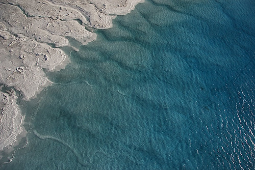
Sapphire-blue pools connected by threadlike streams of water dot the western edge of the Greenland ice sheet in this image, taken on September 13, 2000, by the Enhanced Thematic Mapper Plus sensor aboard the Landsat 7 satellite. Thinner than the 2.3-kilometer-thick center, the outer edges of the Greenland ice sheet develop melt zones like the one shown here during the warm summer months.

http://earthobservatory.nasa.gov/Newsroom/NewImages/images.php3?img_id=17607


Greenland - August 2005 - Scientist Jason Box (Ohio State University / Byrd Polar Research Center) and second mate Hettie (driving) chart the depth of a melt lake on the Greenland ice sheet using a boat brought in by helicopter.


Copyright Greenpeace/ADavies

Printer Friendly | Permalink |  | Top
hatrack Donating Member (1000+ posts) Send PM | Profile | Ignore Tue Sep-04-07 01:07 PM
Response to Original message
1. Very interesting! K&R!!
:toast:
Printer Friendly | Permalink |  | Top
 
n2doc Donating Member (1000+ posts) Send PM | Profile | Ignore Tue Sep-04-07 01:31 PM
Response to Reply #1
3. I wish they had a 2007 map, though
I looked and this is apparently as new as they have out. Given the sea ice maps you've been posing it would be interesting, to say the least, to see how Greenland is responding...
Printer Friendly | Permalink |  | Top
 
phantom power Donating Member (1000+ posts) Send PM | Profile | Ignore Tue Sep-04-07 01:12 PM
Response to Original message
2. I wonder what we'd see if we could image the sub-surface melt rivers.
Printer Friendly | Permalink |  | Top
 
XemaSab Donating Member (1000+ posts) Send PM | Profile | Ignore Tue Sep-04-07 02:00 PM
Response to Reply #2
5. Just looking at that picture makes me think
"Dude, don't slip." :o
Printer Friendly | Permalink |  | Top
 
phantom power Donating Member (1000+ posts) Send PM | Profile | Ignore Tue Sep-04-07 06:42 PM
Response to Reply #5
9. Yeah, unless you can hold your breath all the way to the ocean.
Printer Friendly | Permalink |  | Top
 
depakid Donating Member (1000+ posts) Send PM | Profile | Ignore Tue Sep-04-07 06:41 PM
Response to Reply #2
8. That's one of the most frightening photos I've ever seen.
Some of those moulins drop 2 miles to the Greenland bedrock!

Yep- it would be very interesting to be able to map the flows beneath the glaciers. It might provide researchers more clues as to the non-linear dynamics going on. As goes Greenland- so goes Antarctica.

Curiously, Fred Pearce referenced that photo in his new Book "With Speed and Violence," and I wanted to hunt that up to show that to a friend of mine so that she could appreciate the scale. I don't know why he didn't include photos along with the text- it would have made a far more powerful presentation.
Printer Friendly | Permalink |  | Top
 
pscot Donating Member (1000+ posts) Send PM | Profile | Ignore Tue Sep-04-07 01:43 PM
Response to Original message
4. The pictures tell the story
One gets the feeling that all this is happening a whole lot faster than anyone anticipated.
Printer Friendly | Permalink |  | Top
 
GliderGuider Donating Member (1000+ posts) Send PM | Profile | Ignore Tue Sep-04-07 02:03 PM
Response to Reply #4
6. How can that be?
Faster than expected? Don't be absurd, that couldn't possibly happen. We understand the Earth's systems perfectly by now, don't we?
Printer Friendly | Permalink |  | Top
 
pscot Donating Member (1000+ posts) Send PM | Profile | Ignore Tue Sep-04-07 08:43 PM
Response to Reply #6
11. Masters of the Universe
That's us.
Printer Friendly | Permalink |  | Top
 
hogwyld Donating Member (1000+ posts) Send PM | Profile | Ignore Tue Sep-04-07 05:56 PM
Response to Original message
7. Wow! this is fantastic news!!!
Finally, Greenland will be....Green. :sarcasm:
Printer Friendly | Permalink |  | Top
 
progressoid Donating Member (1000+ posts) Send PM | Profile | Ignore Wed Sep-05-07 01:58 PM
Response to Reply #7
12. Sadly, I've actually heard statements like that from freeptards.
"Whats the big deal, I get more summer to golf!"

:banghead:
Printer Friendly | Permalink |  | Top
 
byronius Donating Member (1000+ posts) Send PM | Profile | Ignore Tue Sep-04-07 08:01 PM
Response to Original message
10. K&R.
Printer Friendly | Permalink |  | Top
 
DU AdBot (1000+ posts) Click to send private message to this author Click to view 
this author's profile Click to add 
this author to your buddy list Click to add 
this author to your Ignore list Thu Apr 25th 2024, 07:38 AM
Response to Original message
Advertisements [?]
 Top

Home » Discuss » Topic Forums » Environment/Energy Donate to DU

Powered by DCForum+ Version 1.1 Copyright 1997-2002 DCScripts.com
Software has been extensively modified by the DU administrators


Important Notices: By participating on this discussion board, visitors agree to abide by the rules outlined on our Rules page. Messages posted on the Democratic Underground Discussion Forums are the opinions of the individuals who post them, and do not necessarily represent the opinions of Democratic Underground, LLC.

Home  |  Discussion Forums  |  Journals |  Store  |  Donate

About DU  |  Contact Us  |  Privacy Policy

Got a message for Democratic Underground? Click here to send us a message.

© 2001 - 2011 Democratic Underground, LLC