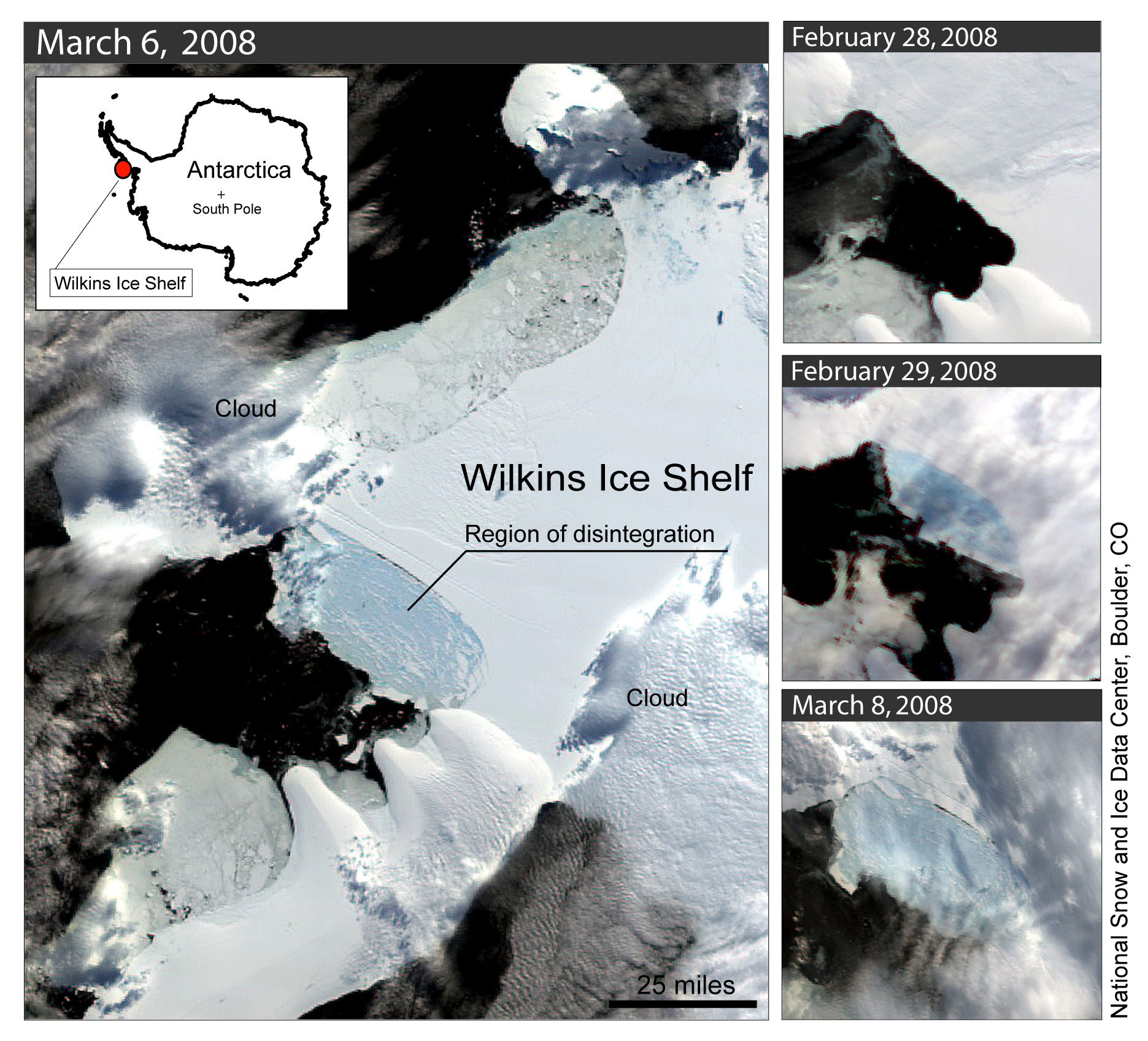
If you'll note the location of the Wilkins Shelf at the base of the Antarctic Peninsula, in the first map you've pasted above, you'll notice that it's near the base of the thumb (so to speak) pointing up towards Cape Horn.
From the location of the Wilkins on the west side, it's at least 400 kilometers to the nearest peninsular volcano at the Seal Nunataks Group, and at least 300 to Peter I Island. Just scroll back and forth between the two maps, and you'll see what I mean - I trust.
USGS classifies four Antarctic volcanoes as "Major" as you'll see by linking to this USGS page - Erebus, Buckle Island, Penguin Island and Deception Island.
http://vulcan.wr.usgs.gov/Volcanoes/Antarctica/Maps/map_antarctica_volcanoes.htmlInteresting data here as well:
From: Simkin and Siebert, 1994, Volcanoes of the World: Geoscience Press, Tucson, Arizona, published in association with the Smithsonian Institution
Although the continent of Antarctica was not discovered until 1840 (by the Wilkes expedition, 12 hours before the French), several nearby island groups were recognized earlier. The northernmost of these, the South Sandwich islands or Scotia Arc, was discovered on Captain Cook's 1772-75 voyage, and one of the group -- Zavodovsky Island -- was issuing a black ash cloud from its summit when discovered by Bellinghausen in 1819. Several other eruptions were reported from these islands in the following years, when fur sealing was at its peak in the region. Sometime between 1825 and 1828, sealers documented an eruption at Deception Island, a natural harbor formed by caldera collapse. And in 1839 an eruption was in progress in the Balleny Islands when they were first discovered by whalers. Two years later, Mount Erebus was erupting when this, the most active volcano in the region, was first sighted.
There followed nearly 60 years of little exploration, although whaling ships continued to work the region through the 19th century. Exploration resumed with a vengence in 1895, with the next two decades known as the "heroic age" in Antarctica. Additional exploration between the World Wars, during the 1957-58 International Geophysical Year, and since the signing of the Antarctic Treaty in 1961 has contributed greatly to understanding this vast region, but it is clear that its historical record of volcanism is both short and very incomplete.
The Antarctic plate, largely aseismic and immobile, is broken internally by large rift structures which have produced one of the world's largest alkalic volcanic provinces. The 3,200-kilometer-long West Antarctic rift system is comparable in size to the better-known East African rift. Volcanic constructs range from large basaltic shields to small monogenetic vents; the presence of the continental icesheet has resulted in a larger volume of hyaloclastite rocks than perhaps any other subaerial volcanic region. The only subduction-related volcanoes within or adjacent to the Antarctic plate form the South Sandwich and South Shetland Islands.
Despite its size,
Antactica ranks below all other regions in number of dated eruptions, and only the Pacific and Atlantic Ocean regions have fewer historically active volcanoes. It's historical record is brief, and 75 percent of its eruptions are from this century. Precise dating of past eruptions is difficult -- much of the landscape is glacier-covered, travel is daunting, and the wood needed for radiocarbon dating does not grow in this extreme climate -- and the region has the highest proportion of volcanoes with uncertain status.
--------------------------------------------------------------------------------
From: Simkin and Siebert, 1994, Volcanoes of the World: Geoscience Press, Tucson, Arizona, published in association with the Smithsonian Institution
Andrus, Shields, 2,978 meters, Holocene ?
Buckle Island, Stratovolcano, 1,230 meters, Historical
Deception Island, Caldera, 576 meters, Historical
Erebus, Stratovolcano, 3,794 meters, Historical
Hudson Mountains, Stratovolcanoes, 749 meters, Uncertain, possibly 1985 ?
Paulet, Cinder Cone, 353 meters, Holocene, 1850
Penguin Island, Stratovolcano, 180 meters, Lichenometry, possibly 1905 ?
Peter I Island, Shield, 1,640 meters, Holocene
Royal Society Range, Cinder Cones, 3,000 meters, Holocene ?
Seal Nunataks Group, Pyroclastic Cones, 368 meters, Historical
Siple, Shield, 3,110 meters, Holocene ?
Tony Mountain, Shield, 3,595 meters, Holocene ?
Unnamed Scoria Cones, 2,987 meters, Holocene ?
Unnamed Submarine Volcano, -500 meters, Holocene ?
Unnamed Submarine Volcano, Uncertain, possibly 1876
Waesche, Shields, 3,292 meters, Holocene ?
EDIT
http://vulcan.wr.usgs.gov/Volcanoes/Antarctica/description_antarctica_volcanoes.htmlGot any data on ongoing eruptions? Please feel free to post at your leisure.
 >
>