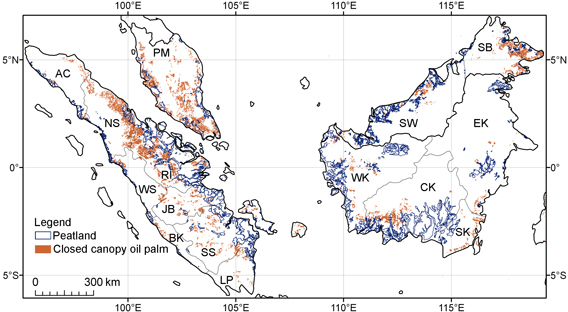
Distribution of closed canopy oil palm plantations and tropical peatlands in the lowlands of Peninsular Malaysia, Borneo and Sumatra. Click image to enlarge.
Expansion of industrial oil palm plantations across Malaysia and Indonesia have laid waste to vast areas of forest and peatlands, exacerbating greenhouse gas emissions and putting biodiversity at risk, reports a new satellite-based analysis that maps mature oil palm estates across Peninsular Malaysia, Borneo, and Sumatra.
The research, published in the journal, Proceedings of the National Academy of Sciences (PNAS), finds that closed canopy oil palm plantations covered 8.3 million ha in 2010, including 2 million ha in Peninsular Malaysia, 2.4 million ha in Borneo, and 3.9 million ha in Sumatra. The analysis is conservative: it only accounts for mature plantationsthose established in 2002 or earlierthat are over 200 ha. But while the map excludes smaller and/or immature plantations (thought to cover at least another 3 million ha in Malaysia and Indonesia), the work represents an important development in determining the extent of oil palm expansion in Southeast Asia.
Conservationists have been asking for a satellite-based map of oil palm for a long time," Lian Pin Koh, lead author and an ecologist at ETH Zürich, told mongabay.com. "Now that we have developed this semi-autonomous method for identifying mature oil palm from satellite images, researchers and environmental groups can use it to detect oil palm expansion. More importantly it can be used to monitor any encroachment of oil palm onto tropical rainforests. The same tool can be used in other regions, such as Africa or Latin America, experiencing oil palm development."
EDIT
"Conversion of peatswamp forests to oil palm led to biodiversity declines of 1% in Borneo (equivalent to four species of forest-dwelling birds), 3.4% in Sumatra (16 species), and 12.1% in Peninsular Malaysia (46 species)," they write. Birds were used as a proxy for biodiversity loss. Other studies have shown oil palm plantations house substantially fewer species up to 80 percent less than natural forests.
EDIT
http://news.mongabay.com/2011/0307-koh_palm_oil.html