NASA image acquired April 9, 2011
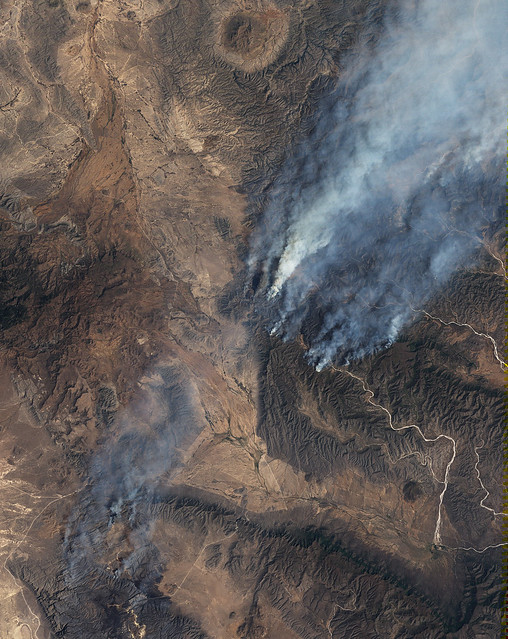
This image, taken by the Landsat-5 satellite on April 9, 2011, illustrate the challenges facing firefighters combating two large wildfires in northern Mexicos Coahuila state. The fires are burning on steep mountain slopes that are difficult to impossible for ground crews to reach. The image shows dense plumes of smoke blowing northeast on strong winds.
The fires, called El Bonito and La Sabina, were caused by lightning strikes in mid-March and had burned 99,000 hectares (245,000 acres or 380 square miles) as of April 11. The fires are among the largest in Mexicos history, according to news reports.
The fires are burning mostly grass and shrub land, ecosystems that are adapted to fire, says the Comisión Nacional Forestal (CONAFOR, Mexicos National Forest Service). Lack of winter rain and frost left the plants dry and prone to fire. On top of that, the area has not burned for more than 20 years, during which time fuel built up. Thunderstorms and steady strong winds with gusts up to 70 miles per hour completed the formula for a dangerous, fast-moving wildfire.
NASA Earth Observatory image created by Jesse Allen, using Landsat 5 data provided by the United States Geological Survey. Caption by Holli Riebeek.
Instrument: Landsat 5 - TM
To download the full high res file to go: earthobservatory.nasa.gov/IOTD/view.php?id=50087
Credit: NASA Earth Observatory
NASA Goddard Space Flight Center enables NASAs mission through four scientific endeavors: Earth Science, Heliophysics, Solar System Exploration, and Astrophysics. Goddard plays a leading role in NASAs accomplishments by contributing compelling scientific knowledge to advance the Agencys mission.
http://www.flickr.com/photos/gsfc/5619120519/