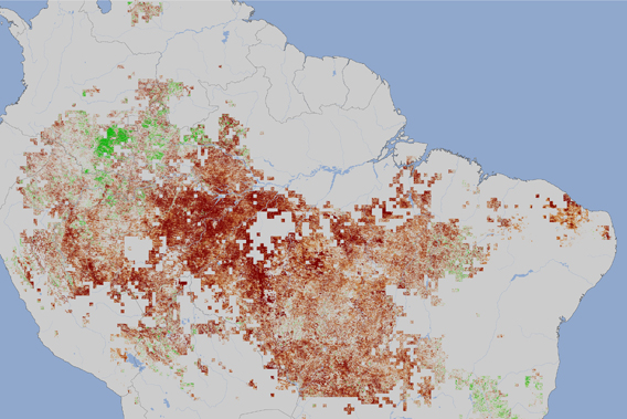
 From NASA: image from the Moderate Resolution Imaging Spectroradiometer (MODIS) on NASAs Terra satellite, the image shows vegetation 'greenness' during the 2010 drought, between July and September, compared to average conditions for the same period between 2000 and 2009 (except for 2005, the other drought year). The redder the image the less 'green' the forest. The "greenness index" measures how much photosynthesis could be happening based on how much leafy vegetation the satellite sees. In 2010, the vegetation index recorded lower values than in previous years, an indication that trees under drought stress either produced fewer leaves or the chlorophyll content of leaves was lower, or both. Image courtesy of NASA. Click to enlarge.
 NASA has revealed a satellite image of the crippling effect of last year's record-breaking drought on the Amazon ecosystem. For those of you counting, that's two record droughts in the Amazon Basin in 5 years.
The 2010 drought appears more extreme then the drought of 2005 according to recent research, including satellite imagery. A new study in Geophysical Research Letters, found nearly a million square miles (2.5 million square kilometers) saw reduced greenness in 2010. This is more than four times the area impacted by the 2005. Adding in signs of drought stress the total impact of the 2010 drought spreads over 1.68 million square miles (4.35 million square kilometers).
Scientists are concerned that increasing droughts could turn the Amazon rainforest from a vast carbon sink into a carbon source, emitting excessive carbon due to increased wood rot during drought conditions.
EDIT
http://news.mongabay.com/2011/0417-hance_nasa_drought.html