phantom power
 (1000+ posts)
Send PM |
Profile |
Ignore
(1000+ posts)
Send PM |
Profile |
Ignore
|
Tue Sep-20-05 04:15 PM
Original message |
|
These maps look like raw satellite data. Kind of fun to see the difference between real-world data and the "clean" maps they show for public consumption. http://marine.rutgers.edu/mrs/sat_data/?product=sst®ion=gulfmexico¬humbs=0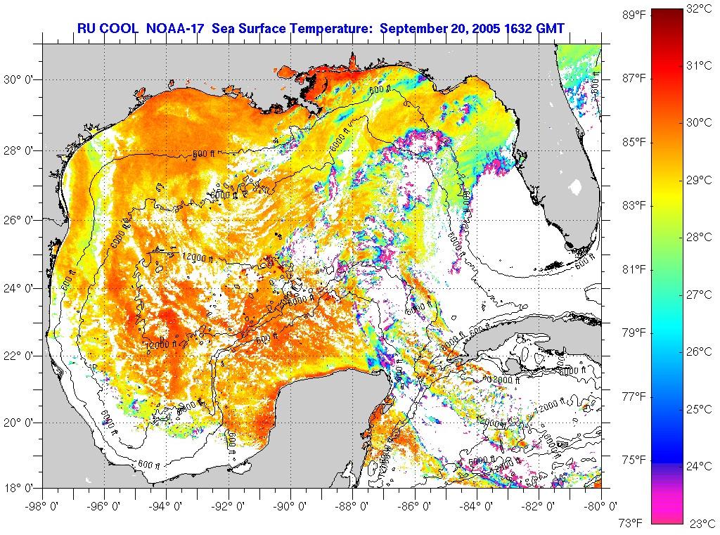 |
| bloom
(1000+ posts)
Send PM |
Profile |
Ignore
|
Tue Sep-20-05 04:56 PM
Response to Original message |
| 1. This one looks a lot worse for some reason... |
| phantom power
(1000+ posts)
Send PM |
Profile |
Ignore
|
Tue Sep-20-05 05:07 PM
Response to Reply #1 |
| 2. real world data is often rather noisy. |
|
The quality of satellite data depends on all kinds of stuff. Cloud cover, orbital path, etc. Probably more things than I know.
|
| NNadir
(1000+ posts)
Send PM |
Profile |
Ignore
|
Tue Sep-20-05 05:25 PM
Response to Original message |
| 3. I understand that the temperature at which hurricanes develop is 26.5C |
|
http://www.wxresearch.com/hurform.htmThese maps are for the most part not comforting.
|
| phantom power
(1000+ posts)
Send PM |
Profile |
Ignore
|
Tue Sep-20-05 05:43 PM
Response to Reply #3 |
| 4. Yes, 80F. Hence, my predictions about Katrina (and Rita) |
|
I've also seen 82F. I don't know which is more correct.
Somebody in another forum told me that wind-shear becomes lower in the fall. That's not good news either, since it's one of the main things that can defuse a hurricane.
|
DU
AdBot (1000+ posts)     |
Fri Apr 26th 2024, 05:12 AM
Response to Original message |