Democratic Underground Latest Greatest Lobby Journals Search Options Help Login
Google

Possible severe weather outbreak on Super Tuesday over Southern US and Ohio River Valley

Printer-friendly format Printer-friendly format
Printer-friendly format Email this thread to a friend
Printer-friendly format Bookmark this thread
This topic is archived.
Home » Discuss » Archives » General Discussion: Presidential (Through Nov 2009) Donate to DU
 
RL3AO Donating Member (1000+ posts) Send PM | Profile | Ignore Sat Feb-02-08 02:03 PM
Original message
Possible severe weather outbreak on Super Tuesday over Southern US and Ohio River Valley
Because of my love for meteorology, I have decided to make a thread discussing the possible severe weather in the US on Super Tuesday.

Four days is a long time to predict a severe weather outbreak, so this could be a complete bust. But I will keep it updated as long as a threat remains.


"MODELS CONTINUE TO INDICATE THE POTENTIAL FOR A SIGNIFICANT SEVERE WEATHER OUTBREAK TUESDAY...POSSIBLY BEGINNING LATE MONDAY NIGHT WEST OF THE MS RIVER." - Memphis Weather Forecast Office

http://www.nws.noaa.gov/view/validProds.php?prod=AFD&node=KMEG

I will have more tomorrow.

http://www.spc.noaa.gov/products/outlook/
Printer Friendly | Permalink |  | Top
Flabbergasted Donating Member (1000+ posts) Send PM | Profile | Ignore Sat Feb-02-08 02:04 PM
Response to Original message
1. More voter suppresion by the Bush administration....nt
Printer Friendly | Permalink |  | Top
 
joshcryer Donating Member (1000+ posts) Send PM | Profile | Ignore Mon Feb-04-08 07:30 AM
Response to Reply #1
17. Think they prayed for it? :P
Printer Friendly | Permalink |  | Top
 
aquart Donating Member (1000+ posts) Send PM | Profile | Ignore Sat Feb-02-08 02:04 PM
Response to Original message
2. Snow? Rain? Cold?
Printer Friendly | Permalink |  | Top
 
RL3AO Donating Member (1000+ posts) Send PM | Profile | Ignore Sat Feb-02-08 02:06 PM
Response to Reply #2
3. Thunderstorms, tornadoes, hail, wind, ect.
Printer Friendly | Permalink |  | Top
 
emilyg Donating Member (1000+ posts) Send PM | Profile | Ignore Sat Feb-02-08 02:41 PM
Response to Reply #3
5. Nothing will stop me from voting.
Printer Friendly | Permalink |  | Top
 
aquart Donating Member (1000+ posts) Send PM | Profile | Ignore Sat Feb-02-08 06:11 PM
Response to Reply #3
7. Ah. Potential death.
Still think there will be a record turnout.
Printer Friendly | Permalink |  | Top
 
Renew Deal Donating Member (1000+ posts) Send PM | Profile | Ignore Sat Feb-02-08 08:12 PM
Response to Reply #2
13. Locusts
:hide:
Printer Friendly | Permalink |  | Top
 
featherman Donating Member (1000+ posts) Send PM | Profile | Ignore Sat Feb-02-08 02:07 PM
Response to Original message
4. Here's an overview from weather.com
Printer Friendly | Permalink |  | Top
 
MediaBabe Donating Member (610 posts) Send PM | Profile | Ignore Sat Feb-02-08 02:41 PM
Response to Original message
6. You're not alone in weather watching
Each evening my local TV station includes a short segment mentioning the national weather and the possible impact it will have next Tuesday. It will be interesting.
Printer Friendly | Permalink |  | Top
 
aquart Donating Member (1000+ posts) Send PM | Profile | Ignore Sat Feb-02-08 06:18 PM
Response to Reply #6
8. So glad I only have to walk around the corner.
Printer Friendly | Permalink |  | Top
 
MediaBabe Donating Member (610 posts) Send PM | Profile | Ignore Sat Feb-02-08 06:24 PM
Response to Reply #8
9. My state has 100% vote by mail
The postman comes right to my door to get my ballot.
Printer Friendly | Permalink |  | Top
 
aquart Donating Member (1000+ posts) Send PM | Profile | Ignore Sat Feb-02-08 07:28 PM
Response to Reply #9
10. Okay, if you trust your postman.
I like my regular guy, but the vacation replacement is an idiot.
Printer Friendly | Permalink |  | Top
 
leftynyc Donating Member (1000+ posts) Send PM | Profile | Ignore Tue Feb-05-08 07:56 AM
Response to Reply #8
21. I have it easier than that
My polling station is the train station I go to every morning to get to the city. I already voted.
Printer Friendly | Permalink |  | Top
 
ellacott Donating Member (1000+ posts) Send PM | Profile | Ignore Sat Feb-02-08 08:08 PM
Response to Original message
11. Ohio votes in March
Hopefully the weather won't be too bad.
Printer Friendly | Permalink |  | Top
 
Cameron27 Donating Member (1000+ posts) Send PM | Profile | Ignore Sat Feb-02-08 08:10 PM
Response to Original message
12. Excellent idea!
Bookmarking
Printer Friendly | Permalink |  | Top
 
RL3AO Donating Member (1000+ posts) Send PM | Profile | Ignore Sun Feb-03-08 10:23 AM
Response to Original message
14. Update for Sunday morning
Storm Prediction Center is still using some strong wording.


That 30% means there is a 30% chance of a severe weather event (a tornado, 3/4 inch or larger hail, or winds over 58 mph) within a 25 mile radius of any point.

We will see in the SPC issues a moderate risk tomorrow, which are pretty rare for a day 2 forecast.

Excuse the meteorological jibber, but there isn't a public outlook unless there is a moderate or high risk (which seems likely as Tuesday gets closer)

...LA/AR/SERN MO/OH VALLEY EWD TO THE APPALACHIANS...
WIDESPREAD SEVERE WEATHER EVENT -- INCLUDING DAMAGING WINDS AND THE
POTENTIAL FOR TORNADOES -- IS ANTICIPATED ACROSS A LARGE PART OF
THIS REGION.

STORMS SHOULD BE ONGOING ACROSS WRN PORTIONS OF THIS AREA AT THE
START OF THE PERIOD...WHILE SLY FLOW ACROSS THE WARM SECTOR
MAINTAINS A MOIST BOUNDARY LAYER /SURFACE DEWPOINTS APPROACHING 60
AS FAR N AS THE LOWER AND MIDDLE OH RIVER VALLEY/. WHILE STORMS ARE
FORECAST WITHIN BROAD ZONE OF WARM ADVECTION WELL AHEAD OF THE
FRONT...GREATEST SEVERE POTENTIAL IS FORECAST CLOSER TO THE
IMMEDIATE COLD FRONT AS IT ADVANCES EWD. WITH TIME...EXPECT A
SQUALL LINE TO DEVELOP ALONG THIS FRONT...AND THEN CONTINUE EWD
THROUGH THE AFTERNOON AND INTO THE EVENING.

WHILE STRONG/DAMAGING WINDS ARE EXPECTED TO BE THE MAIN SEVERE
THREAT...LOW-LEVEL WINDS VEERING/INCREASING WITH HEIGHT WILL LIKELY
RESULT IN LOW-LEVEL ROTATION -- BOTH WITHIN SMALL-SCALE BOWS ALONG
THE LARGER CONVECTIVE LINE AS WELL AS WITH ANY STRONGER CELLS AHEAD
OF THE MAIN LINE. THEREFORE...TORNADOES ARE ALSO ANTICIPATED --
WITH THE POTENTIAL SPREAD ACROSS A BROAD ZONE FROM THE GULF COAST
NWD ACROSS THE TN VALLEY AND PERHAPS INTO THE OH VALLEY.

Printer Friendly | Permalink |  | Top
 
RL3AO Donating Member (1000+ posts) Send PM | Profile | Ignore Sun Feb-03-08 02:24 PM
Response to Original message
15. A few more things.
Jackson AFD
.DAYS TWO THROUGH SEVEN...MONDAY THROUGH SATURDAY

A POTENTIALLY SIGNIFICANT AND WIDESPREAD SEVERE WEATHER EVENT IS
POSSIBLE ON TUESDAY. INSTABILITY AND WIND FIELDS WILL BE SUFFICIENT
TO SUPPORT DAMAGING WINDS...LARGE HAIL AND TORNADOES. THIS ACTIVITY
IS EXPECTED AHEAD OF A COLD FRONT THAT WILL MOVE ACROSS THE AREA
TUESDAY NIGHT.

Memphis AFD
THERE IS THE POTENTIAL FOR A WIDESPREAD SEVERE WEATHER OUTBREAK
ACROSS THE MID-SOUTH TUESDAY. A STRONG COLD FRONT WILL MOVE INTO
THE AREA FROM THE WEST TUESDAY COLLIDING WITH THE UNSEASONABLY
WARM...MOIST AND UNSTABLE AIR IN PLACE. DAMAGING WINDS AND LARGE
HAIL ARE POSSIBLE ALONG WITH THE THREAT OF TORNADOES.
MID-SOUTHERNERS SHOULD KEEP TOUCH WITH THE LATEST FORECASTS
CONCERNING THE SEVERE WEATHER POTENTIAL TUESDAY.
Printer Friendly | Permalink |  | Top
 
RL3AO Donating Member (1000+ posts) Send PM | Profile | Ignore Mon Feb-04-08 07:26 AM
Response to Original message
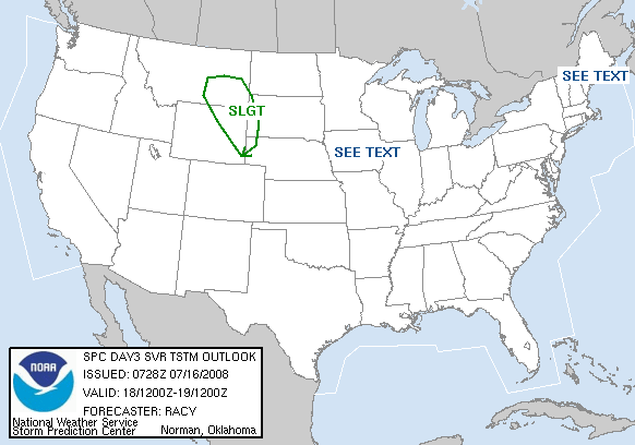
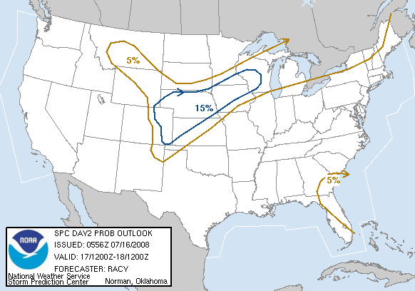
16. Upgraded to moderate risk
Edited on Mon Feb-04-08 07:26 AM by RL3AO


...E TX EWD ACROSS THE LOWER AND MID MS/TN/OH VALLEYS...
WIDESPREAD/SIGNIFICANT SEVERE WEATHER EVENT REMAINS APPARENT THIS
PERIOD FROM THE S CENTRAL CONUS EWD/NEWD TO THE WRN SLOPES OF THE
APPALACHIANS.

ATTM...IT APPEARS THAT STORM MODE WILL BE A MIX OF LINEAR WITH
EMBEDDED COMPLEX STRUCTURES...AND SUPERCELLULAR. WHILE GENERALLY
LIMITED INSTABILITY /MIXED-LAYER CAPE LESS THAN 1000 J/KG/ SHOULD
LIMIT THE POTENTIAL FOR LARGE HAIL...DAMAGING WINDS WILL LIKELY BE
WIDESPREAD. IN ADDITION...TORNADOES ARE ALSO EXPECTED...AND THE
FORECAST DEGREE OF LOW-LEVEL SHEAR SUGGESTS A POTENTIAL THAT A FEW
OF THESE COULD BE STRONG/SIGNIFICANT EVENTS.

http://www.spc.noaa.gov/
Printer Friendly | Permalink |  | Top
 
joshcryer Donating Member (1000+ posts) Send PM | Profile | Ignore Mon Feb-04-08 07:32 AM
Response to Reply #16
18. That's good. Thanks for these reports!
Printer Friendly | Permalink |  | Top
 
RL3AO Donating Member (1000+ posts) Send PM | Profile | Ignore Tue Feb-05-08 01:14 AM
Response to Original message
19. An upgrade to the very rare "high risk" seems likely in the morning.
Edited on Tue Feb-05-08 01:14 AM by RL3AO
UNCERTAINTIES IN THE CONVECTIVE EVOLUTION GIVEN THE
ABOVEMENTIONED...LEAD SHORT WAVE TROUGH AND PRIMARY CONVECTIVE MODE
ARE GREAT ENOUGH SUCH THAT A CATEGORICAL MODERATE RISK WILL BE
MAINTAINED. AN UPGRADE TO HIGH RISK MAY BECOME NECESSARY ONCE
THESE DETAILS BECOME MORE CLEAR.


SPC definition of a high risk: "A HIGH risk area suggests a major severe weather outbreak is expected, with a high concentration of severe weather reports and an enhanced likelihood of extreme severe (i.e., violent tornadoes or very damaging convective wind events occurring across a large area). In a high risk, the potential exists for 20 or more tornadoes, some possibly F2 or stronger, or an extreme derecho potentially causing widespread wind damage and higher end wind gusts (80+ mph) that may result in structural damage"


Tornadoes (Hatched area means large and destructive tornadoes possible/likely)


Severe hail (3/4 in or larger)


Severe wind (58 mph or higher)
Printer Friendly | Permalink |  | Top
 
RL3AO Donating Member (1000+ posts) Send PM | Profile | Ignore Tue Feb-05-08 07:46 AM
Response to Original message
20. Update: HIGH RISK issued for Arkansas, Western Mississippi, and SW Tennessee.
Be safe at the polls.
Printer Friendly | Permalink |  | Top
 
DU AdBot (1000+ posts) Click to send private message to this author Click to view 
this author's profile Click to add 
this author to your buddy list Click to add 
this author to your Ignore list Fri Apr 19th 2024, 12:19 AM
Response to Original message
Advertisements [?]
 Top

Home » Discuss » Archives » General Discussion: Presidential (Through Nov 2009) Donate to DU

Powered by DCForum+ Version 1.1 Copyright 1997-2002 DCScripts.com
Software has been extensively modified by the DU administrators


Important Notices: By participating on this discussion board, visitors agree to abide by the rules outlined on our Rules page. Messages posted on the Democratic Underground Discussion Forums are the opinions of the individuals who post them, and do not necessarily represent the opinions of Democratic Underground, LLC.

Home  |  Discussion Forums  |  Journals |  Store  |  Donate

About DU  |  Contact Us  |  Privacy Policy

Got a message for Democratic Underground? Click here to send us a message.

© 2001 - 2011 Democratic Underground, LLC