First I looked at the leylines and while there is a connector right next to Florida I could not find nor sense anything special there. From there I thought perhaps EarthKeeper would have posted some comments, because he used to work as a geologist for the oil industry - but nothing.
Then I went to so see whether there are any native issues. There are 2 Nations, which appear to be the first inhabitants dating back to 1750 BCE. Plaquemine Culture and the Caddoan Culture.
Artifacts found in the area demonstrate the site was occupied from 1750 BCE to 1500 CE, making it one of the oldest continuously inhabited sites in the region.So I wanted to check about the geomagnetic forces, which are constantly changing of course. Interesting to watch a small video of changes from the 1600's to 1900's at the USGS site. (click on FAQ at site below) Not much there that I felt except perhaps a Uranus energy connection of some sort because the sun gave us the largest recorded flares in 2003. But perhaps someone else can decipher something or have an inspiration. You can also get real-time data and charts from those observatory points.
As a side note it appears they are researching the correlation of earthquakes and geomagnetic fluctuations.
http://geomag.usgs.gov/Ultimately I went & found the reports at the Coastal & Marine Geology Program. I am horrified that this is not widely reported, but having this information, it is even more disappointing that Obama announced more drilling. The drilling activities are utterly irresponsible, we have to stop drilling now. (Based on the facts at the end below)
The report is from an extensive report on the Florida Keys geology. A small chapter examines the impact of drilling for oil. This deep-water well must have been drilled between 1981 and 1986 using modern technology under MMS/OCS regulations. Mind you these are only exploratory wells. Excerpts
This is an aerial of damage you can see from the air. Drilling was done in 1960. Photo taken was 28 years later:
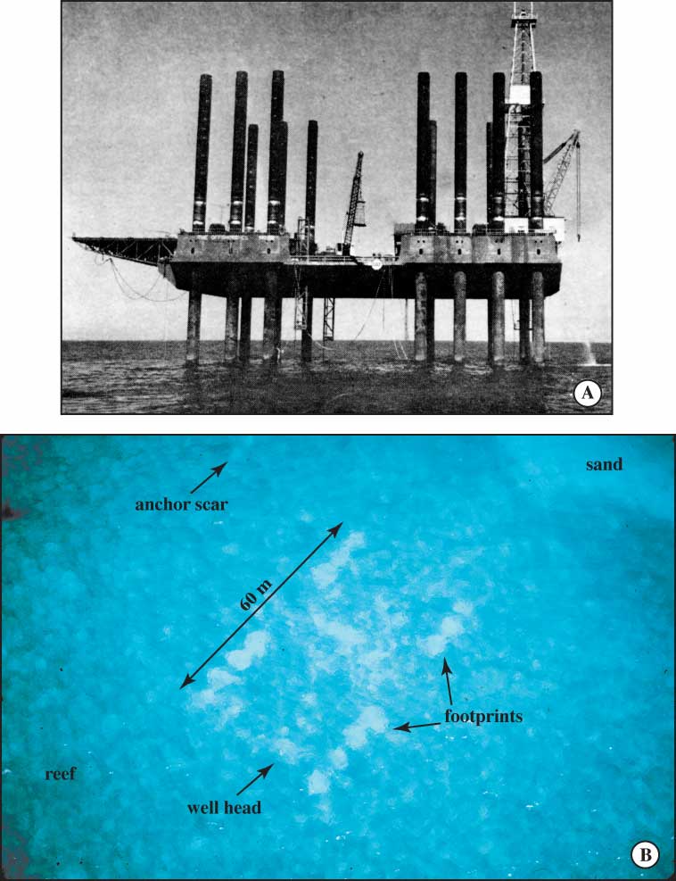 Well Site G4950:
Site G4950 was located on a flat sandy bottom in turbid water 70 m deep (Table 9) and was found by following several large amberjack and a dense school of small silver fish that were attracted to the well bore. The bottom was littered with drilling debris consisting of a length of yellow pipe, a piece of yellow steel grate decking, a chair, two plastic buckets, a large pipe wrench, a short piece of coiled hose, and hundreds of used welding rods (Fig. 126A). A donut-shape mound of grout used to cement casing surrounded the wellhead. Currents had scoured one side of the inner edge of the mound. The grout had obliterated a community of coralgal nodules and plates, red and green algae, starfish, and sponges for a distance of 10 to 15 m around the well bore (Fig. 127B, 127C, 127D). Drilling operations and debris had disrupted the community an additional 10 m beyond (Fig. 127E).

Snip
The major conclusion reached in those studies (Shinn et al., 1989a; Dustan et al., 1991; Shinn and Lidz, 1992; Shinn et al., 1993) was that the exploratory drilling had minimal impact on the benthic environment. With careful placement of the rig or anchors on a sand bottom and if no plastic or metal debris were discarded, only a well bore would be left after time. The well bore would eventually fill with sand, leaving a magnetic anomaly to mark the spot. These conclusions pertain only to exploratory wells and cannot be used to draw conclusions concerning potential ecological impact of production wells on marine communities. (emphasis mine)
Not only have they been trashing the place with human junk.....Magnetic anomaly! activation of faults! Are you f...'ing kidding me?
http://pubs.usgs.gov/pp/2007/1751/professional-paper/tile9-10/oil-wells.htmlNow there is more:
 Figure 1. Possible effects of petroleum production. Prolonged or rapid production of oil, gas, and formation water (2) causes subsurface formation pressures to decline (3). The lowered pressures (3) increase the effective stress of the overburden (4), which causes compaction of the reservoir rocks and may cause formerly active faults (1) to be reactivated (5). Either compaction of the strata or downward displacement along faults can cause land-surface subsidence (6). Where subsidence and fault reactivation occur in wetland areas, the wetlands typically are submerged and changed to open water (7). Figure is not to scale. D, down; U, up.
 Subsidence and Fault Activation Related to Fluid Energy Production, Gulf Coast Basin Project
http://coastal.er.usgs.gov/gc-subsidence/
