| Latest | Greatest | Lobby | Journals | Search | Options | Help | Login |
|
|
|
This topic is archived. |
| Home » Discuss » General Discussion |
|
| Skidmore
|
Sat Mar-12-11 07:03 PM Original message |
| Does anyone know if there is a good graphic representation of what happened under the sea |
| Printer Friendly | Permalink | | Top |
| ReggieVeggie
|
Sat Mar-12-11 07:09 PM Response to Original message |
| 1. here's a quick google |
| Printer Friendly | Permalink | | Top |
| ReggieVeggie
|
Sat Mar-12-11 07:11 PM Response to Reply #1 |
| 2. another |
| Printer Friendly | Permalink | | Top |
| Skidmore
|
Sat Mar-12-11 07:11 PM Response to Reply #1 |
| 3. Thank you. |
| Printer Friendly | Permalink | | Top |
| uppityperson
|
Sat Mar-12-11 07:18 PM Response to Reply #3 |
| 5. Also realize it is not just a wave hitting shore, but backed up by a lot of water/force |
| Printer Friendly | Permalink | | Top |
| pokerfan
|
Sat Mar-12-11 07:17 PM Response to Original message |
| 4. This is from the 2004 Sumatra tsunami |
| Printer Friendly | Permalink | | Top |
| On the Road
|
Sat Mar-12-11 08:12 PM Response to Original message |
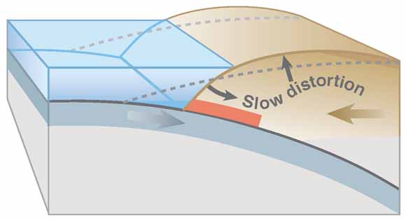
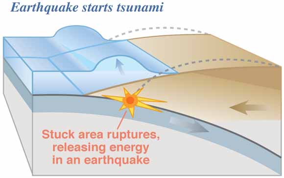
| 6. I Believe It Was Due to a Subduction Zone |
| Printer Friendly | Permalink | | Top |
| EstimatedProphet
|
Sat Mar-12-11 08:23 PM Response to Original message |
| 7. Not exactly what you're looking for, but related - and interesting |
| Printer Friendly | Permalink | | Top |
| DU
AdBot (1000+ posts) |
Fri Apr 26th 2024, 05:53 AM Response to Original message |
| Advertisements [?] |
| Top |
| Home » Discuss » General Discussion |
|
Powered by DCForum+ Version 1.1 Copyright 1997-2002 DCScripts.com
Software has been extensively modified by the DU administrators
Important Notices: By participating on this discussion board, visitors agree to abide by the rules outlined on our Rules page. Messages posted on the Democratic Underground Discussion Forums are the opinions of the individuals who post them, and do not necessarily represent the opinions of Democratic Underground, LLC.
Home | Discussion Forums | Journals | Store | Donate
About DU | Contact Us | Privacy Policy
Got a message for Democratic Underground? Click here to send us a message.
© 2001 - 2011 Democratic Underground, LLC