Welcome to DU!
The truly grassroots left-of-center political community where regular people, not algorithms, drive the discussions and set the standards.
Join the community:
Create a free account
Support DU (and get rid of ads!):
Become a Star Member
Latest Breaking News
General Discussion
The DU Lounge
All Forums
Issue Forums
Culture Forums
Alliance Forums
Region Forums
Support Forums
Help & Search
General Discussion
Related: Editorials & Other Articles, Issue Forums, Alliance Forums, Region Forums27 Years Ago Today; Hurricane Andrew makes landfall at Homestead, FL as a Cat 5
https://en.wikipedia.org/wiki/Hurricane_Andrew

Hurricane Andrew approaching peak intensity over the Bahamas on August 23
Hurricane Andrew was a powerful and destructive Category 5 Atlantic hurricane that struck the Bahamas, Florida, and Louisiana in August 1992. It was the most destructive hurricane to ever hit Florida until Hurricane Irma surpassed it 25 years later. It was the strongest landfalling hurricane in decades and the costliest hurricane to make landfall anywhere in the United States, until it was surpassed by Katrina in 2005. Andrew caused major damage in the Bahamas and Louisiana, but the greatest impact was felt in South Florida, where the storm made landfall as a Category 5 hurricane, with 1-minute sustained wind speeds as high as 165 mph (270 km/h). Passing directly through the city of Homestead in Dade County (now known as Miami-Dade County), Andrew stripped many homes of all but their concrete foundations. In total, Andrew destroyed more than 63,500 houses, damaged more than 124,000 others, caused $27.3 billion in damage, and left 65 people dead.
Andrew began as a tropical depression over the eastern Atlantic Ocean on August 16. After spending a week without significantly strengthening itself in the central Atlantic, it rapidly intensified into a powerful Category 5 hurricane while moving westward towards the Bahamas on August 23. Though it briefly weakened to Category 4 status while traversing the Bahamas, it regained Category 5 intensity before making landfall in Florida on Elliott Key and then Homestead on August 24. With a barometric pressure of 922 mbar (27.23 inHg) at the time of landfall in Florida, Andrew is the sixth most-intense hurricane to strike the United States. Several hours later, the hurricane emerged over the Gulf of Mexico at Category 4 strength, with the Gulf Coast of the United States in its dangerous path. After turning northwestward and weakening further, Andrew moved ashore near Morgan City, Louisiana, as a low-end Category 3 storm. After moving inland, the small hurricane curved northeastward and rapidly lost its intensity, merging with a frontal system over the southern Appalachian Mountains on August 29.
Hurricane Andrew first inflicted structural damage as it moved through the Bahamas, especially in Cat Cays, lashing the islands with storm surge, hurricane-force winds, and tornadoes. About 800 houses were destroyed in the archipelago, and there was substantial damage to the transport, water, sanitation, agriculture, and fishing sectors. Andrew left four dead and $250 million in damage throughout the Bahamas. In parts of southern Florida, Andrew produced severe winds; a wind gust of 177 mph (282 km/h) was observed at a house in Perrine. The cities of Florida City, Homestead, and Cutler Ridge received the brunt of the storm. As many as 1.4 million people lost power at the height of the storm. In the Everglades, 70,000 acres (280 km2) of trees were downed, while invasive Burmese pythons began inhabiting the region after a nearby facility housing them was destroyed. Rainfall in Florida was substantial, peaking at 13.98 inches (355 mm) in western Dade County. In Florida, Andrew killed 44 and left a record $25 billion in damage.
Prior to making landfall in Louisiana on August 26, Andrew caused extensive damage to oil platforms in the Gulf of Mexico, leading to $500 million in losses for oil companies. It produced hurricane-force winds along its path through Louisiana, damaging large stretches of power lines that left about 230,000 people without electricity. Over 80% of trees in the Atchafalaya River basin were downed, and the agriculture there was devastated. Throughout the basin and Bayou Lafourche, 187 million freshwater fish were killed in the hurricane. With 23,000 houses damaged, 985 others destroyed, and 1,951 mobile homes demolished, property losses in Louisiana exceeded $1.5 billion. The hurricane caused the deaths of 17 people in the state, 6 of whom drowned offshore. Andrew spawned at least 28 tornadoes along the Gulf Coast, especially in Alabama, Georgia, and Mississippi. In total, Andrew left 65 dead and caused $27.3 billion in damage. It is currently the seventh-costliest Atlantic hurricane to hit the United States, behind only Katrina (2005), Ike (2008), Sandy (2012), Harvey (2017), Irma (2017), and Maria (2017), as well as the eighth-costliest Atlantic hurricane, behind the aforementioned systems and Wilma (2005). It is the third-strongest hurricane to hit the U.S. mainland by wind speed (165 mph).
<snip>
Impact
Though Andrew was a small tropical cyclone for most of its lifespan, it caused extreme damage, especially in the Bahamas, Florida, and Louisiana. The vast majority of the damage was as a result of extremely high winds, although a few tornadoes spawned by Andrew caused considerable damage in Louisiana. Throughout the areas affected, almost 177,000 people were left homeless. Outside of the Bahamas, Florida, and Louisiana, effects were widespread, although damage was minimal. Overall, $27.3 billion in losses and 65 fatalities were attributed to Andrew, with some estimates ranging as high as $34 billion. Andrew was the costliest hurricane in U.S. history at the time, but is now seventh following hurricanes Katrina (2005), Ike (2008), Sandy (2012), Harvey (2017), Irma (2017), and Maria (2017).
Bahamas
In the Bahamas, Andrew produced hurricane-force winds in North Eleuthera, New Providence, North Andros, Bimini, and the Berry Islands. The storm first struck North Eleuthera, where it produced a high storm surge. At a small village in the northwestern portion of the island, more than half of the houses were destroyed and the rest of the buildings sustained minor to major damage. One person drowned from the surge in Lower Bogue, Eleuthera, and two others died in The Bluff. On Current Island, the hurricane destroyed 24 of the 30 houses. Harbour Island, near Eleuthera, reported wind gusts of 138 mph (222 km/h) – the strongest gust speed observed in the Bahamas during Andrew's passage. News reports indicated severe damage to 36 houses on Harbor Island.
Andrew produced several tornadoes in the area. At the capital city of Nassau, sustained winds reached 92 mph (148 km/h), while gusts up to 115 mph (185 km/h) were reported. Only minor damage occurred in Nassau, according to the Bahamas Red Cross, but on the private island of Cat Cay, many expensive homes sustained heavy damage. Much of the northwestern Bahamas received damage, with estimated monetary losses reaching $250 million. A total of 800 houses were destroyed, leaving 1,700 people homeless. Additionally, the storm caused severe damage to the sectors of transport, communications, water, sanitation, agriculture, and fishing. Four deaths in the country were attributed to the hurricane, of which three were direct; the indirect fatality was due to heart failure during the passage of the storm.
Florida
Overall, Andrew caused about $25.3 billion in damage in Florida, making it the costliest hurricane to hit the state at the time. Some estimates in Florida put the damage as high as $32 billion (1992 USD, $57.1 billion 2019 USD). Almost all of the damage in Florida was caused by strong winds. Of the 44 deaths attributed to the storm, 15 were direct fatalities, while 29 were indirectly caused by the storm. It was later noted that if Andrew had been slightly larger or had made landfall a few miles further north, it would have significantly affected Miami and Fort Lauderdale, which would have resulted in an even higher damage and death toll. An analysis by the American Meteorological Society indicated that unlike most hurricanes, wind damage from Andrew was mostly north of the geometric center and occurred primarily on the eastern edge of the storm. Some officials in Florida considered Andrew the worst storm in the state since the Labor Day hurricane in 1935. The storm surge from Andrew caused more than $500 million in losses to boats and buildings. At the height of the storm, more than 1.4 million people lost electricity and another 150,000 were without telephone service. It is estimated that throughout Florida, the storm damaged 101,241 homes and destroyed approximately 63,000 others – the vast majority in Dade County – with about 175,000 people rendered homeless. In addition to homes, the storm damaged or destroyed 82,000 businesses, 32,900 acres (13,300 ha) of farmland, 31 public schools, 59 health facilities/hospitals, 9,500 traffic signals, 3,300 mi (5,300 km) of power lines, and 3,000 watermains. Approximately 20 million cubic yards (15 million m3) of debris left by the storm were disposed of.
Tides were generally between 4 to 6 ft (1.2 to 1.8 m) above normal in the Biscayne Bay area, though near the Burger King International Headquarters, tides reached as high as 16.9 ft (5.2 m) above normal. Storm surge on the west coast was widespread but generally light, with a peak height of 6 ft (1.8 m) in Everglades City and Goodland. Strong winds from the storm were confined to a relatively small area, stretching from Key Largo to the Miami Beach area. A house near Perrine initially reported a wind gust of 212 mph (341 km/h) before the structure and instrument were destroyed; this measurement was reduced to 177 mph (285 km/h), after wind-tunnel testing at the Virginia Polytechnic Institute and State University of the same type of anemometer revealed a 16.5% error. Several other anemometers measuring the highest wind speeds on land were destroyed or failed. At the National Hurricane Center building in Coral Gables, sustained winds of 115 mph (185 km/h) and gusts to 164 mph (264 km/h) were measured before the anemometer failed. The highest sustained wind speed for the storm was 146 mph (235 km/h), recorded at the Turkey Point Nuclear Generating Station, before instruments also failed there. In Key Largo, a 13-minute wind speed of 114 mph (183 km/h) was reported. Tropical storm force winds reached as far north as West Palm Beach. On the west coast of Florida, sustained winds remained just below tropical storm force on Marco Island, though a wind gust of 100 mph (160 km/h) was reported in Collier County. Rainfall was generally light, possibly as a result of the storm's relatively fast movement. Overall, precipitation from Andrew peaked at nearly 14 in (360 mm) in western Dade County. Heavy rainfall in other areas was sporadic, with precipitation reported as far north as Central Florida.

Damage in Lakes by the Bay
Although effects from Andrew were catastrophic, the extent of damage was limited mainly from Kendall to Key Largo due to the small wind field of the storm. The hurricane destroyed 90% of mobile homes in the county, including 99% of mobile homes in Homestead. At the Homestead Air Force Base, most of the 2,000 buildings on the base were severely damaged or rendered unusable. Damage to the base was extensive enough that it was recommended for closure. Nearby, in the small town of Florida City, over 120 homes were demolished and 700 others were damaged, while a number of other buildings were damaged beyond repair, including City Hall Further north, damage to poorly constructed homes in communities such as Country Walk and Saga Bay resembled that of an F3 tornado, as winds in the area were estimated to have ranged from 130 to 150 mph (210 to 240 km/h), below the threshold for an F3 tornado. Four of the five condominiums at Naranja Lakes were destroyed. The Cutler Ridge Mall suffered severe wind and water damage; after the storm, significant looting was reported at that location. More than 50 streets were blocked by fallen trees and power lines. Agriculture suffered extensively as well, with an 85% loss to fruit crops such as avocados, limes, and mangoes. Crop damage in Dade County totaled about $509 million. The county suffered the vast majority of the damage from the hurricane, totaling approximately $25 billion. Andrew left at least 40 deaths in the county, 15 direct and 25 indirect.

The Dadeland Mobile Home Park after Andrew
Elsewhere, effects were relatively minimal, except in Broward, Monroe, and Collier counties. In Broward County, on the north side of the storm's path, impact in several municipalities was primarily limited to downed trees, several of which fell onto roads and power lines. In Pembroke Park, one of the worst impacted cities in the county, approximately 260 mobile homes were damaged. Storm surge left coastal flooding in some areas, especially along state roads A1A and 858. Property damage reached about $100 million and three fatalities were reported in Broward County. In Everglades National Park and Biscayne National Park, more than 25% of trees were damaged or destroyed, including one-fourth of the royal palms and one-third of the pine trees in the former. In addition to the damage at Everglades National Park, effects in Monroe County were significant, especially in the Upper Florida Keys. Strong winds damaged billboards, awnings, commercial signs, several boats, planes, trees, and 1,500 homes, with 300 of those becoming uninhabitable. Damage in that county was about $131 million. In Collier County, to the north of the storm's path, sustained winds up to 98 mph (158 km/h) were observed in Chokoloskee. Storm surge flooded low-lying areas, particularly in Goodland, Everglades City, and Marco Island. Many boats were damaged or destroyed by the rough seas and strong winds. The storm destroyed 80 mobile homes and severely damaged 400 others. Property damage in the county reached about $30 million.
Louisiana
Damage from an F3 tornado spawned by Andrew in LaPlace
After hitting Florida, Andrew moved across the Gulf of Mexico and made landfall about 23 mi (37 km) west-southwest of Morgan City in south-central Louisiana; at landfall, the maximum sustained winds were 115 mph (185 km/h). The highest sustained wind speed observed was 96 mph (154 km/h), while a wind gust as strong as 120 mph (190 km/h) was recorded; both measurements were taken at the fire station in Berwick. As it moved ashore, the hurricane produced storm tides of at least 8 ft (2.4 m) above normal, causing flooding along the coast from Vermilion Bay to Lake Borgne. Off Louisiana, a group of six fishermen from Alabama drowned. Heavy rains accompanied the storm's passage through the state, peaking at 11.02 in (280 mm) in Robert. River flooding was also reported, with the Tangipahoa River in Robert cresting at 3.8 ft (1.2 m) above flood stage. Before making landfall, Andrew spawned an F3 tornado in LaPlace, which killed two people and injuring 32. The tornado was on the ground for about 10 minutes, during which it damaged or destroyed 163 structures, leaving 60 families homeless. Collectively, 14 tornadoes were reported in the parishes of Ascension, Iberville, Pointe Coupee, and Avoyelles, as well as in Baton Rouge.
Along the Louisiana coastline, impact largely resembled that of a Category 2 hurricane. Damage was heaviest in St. Mary Parish, about 32 mi (51 km) east of where Andrew made landfall. Twenty-six schools were impacted, with damage totaling $2.6 million. Berwick High School, sheltering about 2,000 people, was deroofed during the storm. Generally, single-family homes fared well, with most losing only roofing shingles, though others suffered severe damage after large trees fell on them. In Cypremort Point State Park, several mobile homes were destroyed.[76] Houses in Berwick, Morgan City, and Patterson suffered major damage. Throughout the parish, 1,367 dwellings were destroyed, 2,028 were severely damaged, and 4,770 others were impacted to a minor degree. Property damage alone in St. Mary Parish reached approximately $150 million. Iberia Parish was also among the most severely impacted parishes. Two schools collectively sheltering about 3,600 people in Jeanerette and New Iberia lost their roofs. One death occurred in the parish due to electrocution. A total of 407 residences were demolished, 2,528 others were extensively damaged, and 3,526 others were inflicted with minor damage. Overall, the parish suffered $125 million in property damage, while an additional $200 million in damage was inflicted on sugar crops.
Across the state, the hurricane damaged 23,000 homes and destroyed 985 homes and 1,951 mobile homes; private property damage was estimated at $1 billion. The high winds destroyed large areas of sugar and soybean crops, estimated at $289 million in damage.[75] Strong winds also left at least 230,000 people without electricity. During the storm's passage, upwelling occurred in the Atchafalaya Basin and Bayou Lafourche, killing 187 million freshwater fish. Damage to the fishing industry was estimated at $266 million. Overall, losses in the state of Louisiana reached approximately $1.56 billion. A total of 17 deaths occurred in Louisiana, 8 directly and 9 from indirect causes. At least 75 injuries were reported.
Remainder of the United States
While Andrew was entering the Gulf of Mexico, oil companies evacuated hundreds of employees from offshore drilling platforms. The storm damaged 241 oil and gas facilities and toppled 33 platforms off the coast of Louisiana, causing significant disruptions in production. Additionally, 83 pipeline segments suffered damage to some degree. The oil industry lost about $12 million per day in the days following Andrew and $4 million daily by three weeks later. Initially, a production loss of 240,000 to 270,000 barrels per day occurred – approximately one-third of production throughout the Gulf of Mexico. Overall, Hurricane Andrew caused about $500 million in damage to oil facilities.
As Andrew moved ashore in Louisiana, its outer fringes produced a storm tide of about 1.3 ft (0.40 m) in Sabine Pass, Texas. Winds were generally light in the state, reaching 30 mph (48 km/h) in Port Arthur. As Andrew crossed into Mississippi, 3 severe thunderstorm warnings, 21 tornado warnings, and 16 flood warnings were issued. Funnel clouds were observed near the path of the storm, along with 26 tornadoes. Structural damage was generally minimal, occurring from the tornadoes and severe thunderstorms. One tornado in Kemper County destroyed a mobile home, while another twister in Lauderdale County demolished a mobile home, damaged five other dwellings, and injured four people. Additionally, a possible tornado damaged a home and two trailers in Lawrence County. Strong winds knocked down trees in the southwestern portion of the state. Much of Mississippi received 3 to 5 in (76 to 127 mm) of rain, while areas near the southwest corner of the state observed over 7 in (180 mm) of precipitation, with a peak of 9.30 in (236 mm) at Sumrall. Flooding was mostly limited to the inundation of minor roads and low-lying areas in several counties.
In Alabama, precipitation amounts in the state peaked at 4.71 in (120 mm) in Aliceville. The rainfall caused flooding in low-lying areas and creeks, covering a few county roads but not entering many houses or businesses. Along the coast, the storm produced flooding and high tides. Along Dauphin Island, high tides left severe beach erosion, with portions of the island losing up to 30 ft (9.1 m) of sand. Three damaging tornadoes occurred in the state. The most damaging tornado was spawned in Elmore County and moved from an area northeast of Montgomery to the south of Wetumpka and briefly lifted during its 0.5 mi (0.80 km) track. The tornado destroyed 2 homes and damaged 18 homes, 1 mobile home, 2 barns, and 1 vehicle. One person was injured by the twister. Sustained winds in the state were below tropical storm force, though a wind gust of 41 mph (67 km/h) was observed in Huntsville. Although 48 counties in Alabama reported wind damage, impact across the state was generally minor.
Tropical storm force wind gusts and damaging tornadoes extended eastward into Georgia. Several counties in the northwest and west-central portions of the state reported downed trees and tree limbs and fallen power lines, causing scattered power outages, but structural damage was generally minor. In Carroll County, several dwellings and barns were damaged, with one mobile home destroyed. At the Columbus Metropolitan Airport, buildings, billboards, and signs were damaged. Additionally, a tornado in Floyd County near Rome snapped and uprooted several trees, damaged several fences and homes, and flipped over a trailer, tossing it on top of four cars. Monetary losses in the state reached about $100,000. In Tennessee, thunderstorm winds and tornadoes associated with Andrew downed trees and power lines, but caused little overall impact to homes and buildings. Similarly, in North Carolina, thunderstorm winds toppled trees and power lines at a number of locations in the mountainous areas of the state, especially in Avery County. Rainfall from Andrew spread across the southeastern United States along the Appalachian Mountains corridor; totals of over 5 in (125 mm) were reported where Georgia and South Carolina meet North Carolina. In West Virginia, the remnants of Andrew combined with a cold front to produce 1.5 to 2.5 in (38 to 64 mm) of rain over portions of the state, causing flooding in areas of Morgantown with poor drainage. The remnants of Andrew also spawned several tornadoes in Maryland. A tornado in Howard County damaged several homes, some extensively. The twister also tossed and wrecked a recreational vehicle and its trailer, downed trees, and flattened cornfields. Precipitation continued along the path of Andrew's remnants through the Mid-Atlantic and Ohio Valley, with precipitation measured as far north as Upstate New York.
</snip>
Hurricane Andrew approaching peak intensity over the Bahamas on August 23
Hurricane Andrew was a powerful and destructive Category 5 Atlantic hurricane that struck the Bahamas, Florida, and Louisiana in August 1992. It was the most destructive hurricane to ever hit Florida until Hurricane Irma surpassed it 25 years later. It was the strongest landfalling hurricane in decades and the costliest hurricane to make landfall anywhere in the United States, until it was surpassed by Katrina in 2005. Andrew caused major damage in the Bahamas and Louisiana, but the greatest impact was felt in South Florida, where the storm made landfall as a Category 5 hurricane, with 1-minute sustained wind speeds as high as 165 mph (270 km/h). Passing directly through the city of Homestead in Dade County (now known as Miami-Dade County), Andrew stripped many homes of all but their concrete foundations. In total, Andrew destroyed more than 63,500 houses, damaged more than 124,000 others, caused $27.3 billion in damage, and left 65 people dead.
Andrew began as a tropical depression over the eastern Atlantic Ocean on August 16. After spending a week without significantly strengthening itself in the central Atlantic, it rapidly intensified into a powerful Category 5 hurricane while moving westward towards the Bahamas on August 23. Though it briefly weakened to Category 4 status while traversing the Bahamas, it regained Category 5 intensity before making landfall in Florida on Elliott Key and then Homestead on August 24. With a barometric pressure of 922 mbar (27.23 inHg) at the time of landfall in Florida, Andrew is the sixth most-intense hurricane to strike the United States. Several hours later, the hurricane emerged over the Gulf of Mexico at Category 4 strength, with the Gulf Coast of the United States in its dangerous path. After turning northwestward and weakening further, Andrew moved ashore near Morgan City, Louisiana, as a low-end Category 3 storm. After moving inland, the small hurricane curved northeastward and rapidly lost its intensity, merging with a frontal system over the southern Appalachian Mountains on August 29.
Hurricane Andrew first inflicted structural damage as it moved through the Bahamas, especially in Cat Cays, lashing the islands with storm surge, hurricane-force winds, and tornadoes. About 800 houses were destroyed in the archipelago, and there was substantial damage to the transport, water, sanitation, agriculture, and fishing sectors. Andrew left four dead and $250 million in damage throughout the Bahamas. In parts of southern Florida, Andrew produced severe winds; a wind gust of 177 mph (282 km/h) was observed at a house in Perrine. The cities of Florida City, Homestead, and Cutler Ridge received the brunt of the storm. As many as 1.4 million people lost power at the height of the storm. In the Everglades, 70,000 acres (280 km2) of trees were downed, while invasive Burmese pythons began inhabiting the region after a nearby facility housing them was destroyed. Rainfall in Florida was substantial, peaking at 13.98 inches (355 mm) in western Dade County. In Florida, Andrew killed 44 and left a record $25 billion in damage.
Prior to making landfall in Louisiana on August 26, Andrew caused extensive damage to oil platforms in the Gulf of Mexico, leading to $500 million in losses for oil companies. It produced hurricane-force winds along its path through Louisiana, damaging large stretches of power lines that left about 230,000 people without electricity. Over 80% of trees in the Atchafalaya River basin were downed, and the agriculture there was devastated. Throughout the basin and Bayou Lafourche, 187 million freshwater fish were killed in the hurricane. With 23,000 houses damaged, 985 others destroyed, and 1,951 mobile homes demolished, property losses in Louisiana exceeded $1.5 billion. The hurricane caused the deaths of 17 people in the state, 6 of whom drowned offshore. Andrew spawned at least 28 tornadoes along the Gulf Coast, especially in Alabama, Georgia, and Mississippi. In total, Andrew left 65 dead and caused $27.3 billion in damage. It is currently the seventh-costliest Atlantic hurricane to hit the United States, behind only Katrina (2005), Ike (2008), Sandy (2012), Harvey (2017), Irma (2017), and Maria (2017), as well as the eighth-costliest Atlantic hurricane, behind the aforementioned systems and Wilma (2005). It is the third-strongest hurricane to hit the U.S. mainland by wind speed (165 mph).
<snip>
Impact
Though Andrew was a small tropical cyclone for most of its lifespan, it caused extreme damage, especially in the Bahamas, Florida, and Louisiana. The vast majority of the damage was as a result of extremely high winds, although a few tornadoes spawned by Andrew caused considerable damage in Louisiana. Throughout the areas affected, almost 177,000 people were left homeless. Outside of the Bahamas, Florida, and Louisiana, effects were widespread, although damage was minimal. Overall, $27.3 billion in losses and 65 fatalities were attributed to Andrew, with some estimates ranging as high as $34 billion. Andrew was the costliest hurricane in U.S. history at the time, but is now seventh following hurricanes Katrina (2005), Ike (2008), Sandy (2012), Harvey (2017), Irma (2017), and Maria (2017).
Bahamas
In the Bahamas, Andrew produced hurricane-force winds in North Eleuthera, New Providence, North Andros, Bimini, and the Berry Islands. The storm first struck North Eleuthera, where it produced a high storm surge. At a small village in the northwestern portion of the island, more than half of the houses were destroyed and the rest of the buildings sustained minor to major damage. One person drowned from the surge in Lower Bogue, Eleuthera, and two others died in The Bluff. On Current Island, the hurricane destroyed 24 of the 30 houses. Harbour Island, near Eleuthera, reported wind gusts of 138 mph (222 km/h) – the strongest gust speed observed in the Bahamas during Andrew's passage. News reports indicated severe damage to 36 houses on Harbor Island.
Andrew produced several tornadoes in the area. At the capital city of Nassau, sustained winds reached 92 mph (148 km/h), while gusts up to 115 mph (185 km/h) were reported. Only minor damage occurred in Nassau, according to the Bahamas Red Cross, but on the private island of Cat Cay, many expensive homes sustained heavy damage. Much of the northwestern Bahamas received damage, with estimated monetary losses reaching $250 million. A total of 800 houses were destroyed, leaving 1,700 people homeless. Additionally, the storm caused severe damage to the sectors of transport, communications, water, sanitation, agriculture, and fishing. Four deaths in the country were attributed to the hurricane, of which three were direct; the indirect fatality was due to heart failure during the passage of the storm.
Florida
Overall, Andrew caused about $25.3 billion in damage in Florida, making it the costliest hurricane to hit the state at the time. Some estimates in Florida put the damage as high as $32 billion (1992 USD, $57.1 billion 2019 USD). Almost all of the damage in Florida was caused by strong winds. Of the 44 deaths attributed to the storm, 15 were direct fatalities, while 29 were indirectly caused by the storm. It was later noted that if Andrew had been slightly larger or had made landfall a few miles further north, it would have significantly affected Miami and Fort Lauderdale, which would have resulted in an even higher damage and death toll. An analysis by the American Meteorological Society indicated that unlike most hurricanes, wind damage from Andrew was mostly north of the geometric center and occurred primarily on the eastern edge of the storm. Some officials in Florida considered Andrew the worst storm in the state since the Labor Day hurricane in 1935. The storm surge from Andrew caused more than $500 million in losses to boats and buildings. At the height of the storm, more than 1.4 million people lost electricity and another 150,000 were without telephone service. It is estimated that throughout Florida, the storm damaged 101,241 homes and destroyed approximately 63,000 others – the vast majority in Dade County – with about 175,000 people rendered homeless. In addition to homes, the storm damaged or destroyed 82,000 businesses, 32,900 acres (13,300 ha) of farmland, 31 public schools, 59 health facilities/hospitals, 9,500 traffic signals, 3,300 mi (5,300 km) of power lines, and 3,000 watermains. Approximately 20 million cubic yards (15 million m3) of debris left by the storm were disposed of.
Tides were generally between 4 to 6 ft (1.2 to 1.8 m) above normal in the Biscayne Bay area, though near the Burger King International Headquarters, tides reached as high as 16.9 ft (5.2 m) above normal. Storm surge on the west coast was widespread but generally light, with a peak height of 6 ft (1.8 m) in Everglades City and Goodland. Strong winds from the storm were confined to a relatively small area, stretching from Key Largo to the Miami Beach area. A house near Perrine initially reported a wind gust of 212 mph (341 km/h) before the structure and instrument were destroyed; this measurement was reduced to 177 mph (285 km/h), after wind-tunnel testing at the Virginia Polytechnic Institute and State University of the same type of anemometer revealed a 16.5% error. Several other anemometers measuring the highest wind speeds on land were destroyed or failed. At the National Hurricane Center building in Coral Gables, sustained winds of 115 mph (185 km/h) and gusts to 164 mph (264 km/h) were measured before the anemometer failed. The highest sustained wind speed for the storm was 146 mph (235 km/h), recorded at the Turkey Point Nuclear Generating Station, before instruments also failed there. In Key Largo, a 13-minute wind speed of 114 mph (183 km/h) was reported. Tropical storm force winds reached as far north as West Palm Beach. On the west coast of Florida, sustained winds remained just below tropical storm force on Marco Island, though a wind gust of 100 mph (160 km/h) was reported in Collier County. Rainfall was generally light, possibly as a result of the storm's relatively fast movement. Overall, precipitation from Andrew peaked at nearly 14 in (360 mm) in western Dade County. Heavy rainfall in other areas was sporadic, with precipitation reported as far north as Central Florida.
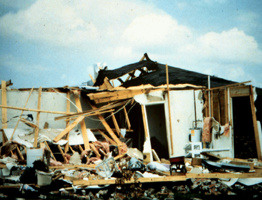
Damage in Lakes by the Bay
Although effects from Andrew were catastrophic, the extent of damage was limited mainly from Kendall to Key Largo due to the small wind field of the storm. The hurricane destroyed 90% of mobile homes in the county, including 99% of mobile homes in Homestead. At the Homestead Air Force Base, most of the 2,000 buildings on the base were severely damaged or rendered unusable. Damage to the base was extensive enough that it was recommended for closure. Nearby, in the small town of Florida City, over 120 homes were demolished and 700 others were damaged, while a number of other buildings were damaged beyond repair, including City Hall Further north, damage to poorly constructed homes in communities such as Country Walk and Saga Bay resembled that of an F3 tornado, as winds in the area were estimated to have ranged from 130 to 150 mph (210 to 240 km/h), below the threshold for an F3 tornado. Four of the five condominiums at Naranja Lakes were destroyed. The Cutler Ridge Mall suffered severe wind and water damage; after the storm, significant looting was reported at that location. More than 50 streets were blocked by fallen trees and power lines. Agriculture suffered extensively as well, with an 85% loss to fruit crops such as avocados, limes, and mangoes. Crop damage in Dade County totaled about $509 million. The county suffered the vast majority of the damage from the hurricane, totaling approximately $25 billion. Andrew left at least 40 deaths in the county, 15 direct and 25 indirect.
The Dadeland Mobile Home Park after Andrew
Elsewhere, effects were relatively minimal, except in Broward, Monroe, and Collier counties. In Broward County, on the north side of the storm's path, impact in several municipalities was primarily limited to downed trees, several of which fell onto roads and power lines. In Pembroke Park, one of the worst impacted cities in the county, approximately 260 mobile homes were damaged. Storm surge left coastal flooding in some areas, especially along state roads A1A and 858. Property damage reached about $100 million and three fatalities were reported in Broward County. In Everglades National Park and Biscayne National Park, more than 25% of trees were damaged or destroyed, including one-fourth of the royal palms and one-third of the pine trees in the former. In addition to the damage at Everglades National Park, effects in Monroe County were significant, especially in the Upper Florida Keys. Strong winds damaged billboards, awnings, commercial signs, several boats, planes, trees, and 1,500 homes, with 300 of those becoming uninhabitable. Damage in that county was about $131 million. In Collier County, to the north of the storm's path, sustained winds up to 98 mph (158 km/h) were observed in Chokoloskee. Storm surge flooded low-lying areas, particularly in Goodland, Everglades City, and Marco Island. Many boats were damaged or destroyed by the rough seas and strong winds. The storm destroyed 80 mobile homes and severely damaged 400 others. Property damage in the county reached about $30 million.
Louisiana
Damage from an F3 tornado spawned by Andrew in LaPlace
After hitting Florida, Andrew moved across the Gulf of Mexico and made landfall about 23 mi (37 km) west-southwest of Morgan City in south-central Louisiana; at landfall, the maximum sustained winds were 115 mph (185 km/h). The highest sustained wind speed observed was 96 mph (154 km/h), while a wind gust as strong as 120 mph (190 km/h) was recorded; both measurements were taken at the fire station in Berwick. As it moved ashore, the hurricane produced storm tides of at least 8 ft (2.4 m) above normal, causing flooding along the coast from Vermilion Bay to Lake Borgne. Off Louisiana, a group of six fishermen from Alabama drowned. Heavy rains accompanied the storm's passage through the state, peaking at 11.02 in (280 mm) in Robert. River flooding was also reported, with the Tangipahoa River in Robert cresting at 3.8 ft (1.2 m) above flood stage. Before making landfall, Andrew spawned an F3 tornado in LaPlace, which killed two people and injuring 32. The tornado was on the ground for about 10 minutes, during which it damaged or destroyed 163 structures, leaving 60 families homeless. Collectively, 14 tornadoes were reported in the parishes of Ascension, Iberville, Pointe Coupee, and Avoyelles, as well as in Baton Rouge.
Along the Louisiana coastline, impact largely resembled that of a Category 2 hurricane. Damage was heaviest in St. Mary Parish, about 32 mi (51 km) east of where Andrew made landfall. Twenty-six schools were impacted, with damage totaling $2.6 million. Berwick High School, sheltering about 2,000 people, was deroofed during the storm. Generally, single-family homes fared well, with most losing only roofing shingles, though others suffered severe damage after large trees fell on them. In Cypremort Point State Park, several mobile homes were destroyed.[76] Houses in Berwick, Morgan City, and Patterson suffered major damage. Throughout the parish, 1,367 dwellings were destroyed, 2,028 were severely damaged, and 4,770 others were impacted to a minor degree. Property damage alone in St. Mary Parish reached approximately $150 million. Iberia Parish was also among the most severely impacted parishes. Two schools collectively sheltering about 3,600 people in Jeanerette and New Iberia lost their roofs. One death occurred in the parish due to electrocution. A total of 407 residences were demolished, 2,528 others were extensively damaged, and 3,526 others were inflicted with minor damage. Overall, the parish suffered $125 million in property damage, while an additional $200 million in damage was inflicted on sugar crops.
Across the state, the hurricane damaged 23,000 homes and destroyed 985 homes and 1,951 mobile homes; private property damage was estimated at $1 billion. The high winds destroyed large areas of sugar and soybean crops, estimated at $289 million in damage.[75] Strong winds also left at least 230,000 people without electricity. During the storm's passage, upwelling occurred in the Atchafalaya Basin and Bayou Lafourche, killing 187 million freshwater fish. Damage to the fishing industry was estimated at $266 million. Overall, losses in the state of Louisiana reached approximately $1.56 billion. A total of 17 deaths occurred in Louisiana, 8 directly and 9 from indirect causes. At least 75 injuries were reported.
Remainder of the United States
While Andrew was entering the Gulf of Mexico, oil companies evacuated hundreds of employees from offshore drilling platforms. The storm damaged 241 oil and gas facilities and toppled 33 platforms off the coast of Louisiana, causing significant disruptions in production. Additionally, 83 pipeline segments suffered damage to some degree. The oil industry lost about $12 million per day in the days following Andrew and $4 million daily by three weeks later. Initially, a production loss of 240,000 to 270,000 barrels per day occurred – approximately one-third of production throughout the Gulf of Mexico. Overall, Hurricane Andrew caused about $500 million in damage to oil facilities.
As Andrew moved ashore in Louisiana, its outer fringes produced a storm tide of about 1.3 ft (0.40 m) in Sabine Pass, Texas. Winds were generally light in the state, reaching 30 mph (48 km/h) in Port Arthur. As Andrew crossed into Mississippi, 3 severe thunderstorm warnings, 21 tornado warnings, and 16 flood warnings were issued. Funnel clouds were observed near the path of the storm, along with 26 tornadoes. Structural damage was generally minimal, occurring from the tornadoes and severe thunderstorms. One tornado in Kemper County destroyed a mobile home, while another twister in Lauderdale County demolished a mobile home, damaged five other dwellings, and injured four people. Additionally, a possible tornado damaged a home and two trailers in Lawrence County. Strong winds knocked down trees in the southwestern portion of the state. Much of Mississippi received 3 to 5 in (76 to 127 mm) of rain, while areas near the southwest corner of the state observed over 7 in (180 mm) of precipitation, with a peak of 9.30 in (236 mm) at Sumrall. Flooding was mostly limited to the inundation of minor roads and low-lying areas in several counties.
In Alabama, precipitation amounts in the state peaked at 4.71 in (120 mm) in Aliceville. The rainfall caused flooding in low-lying areas and creeks, covering a few county roads but not entering many houses or businesses. Along the coast, the storm produced flooding and high tides. Along Dauphin Island, high tides left severe beach erosion, with portions of the island losing up to 30 ft (9.1 m) of sand. Three damaging tornadoes occurred in the state. The most damaging tornado was spawned in Elmore County and moved from an area northeast of Montgomery to the south of Wetumpka and briefly lifted during its 0.5 mi (0.80 km) track. The tornado destroyed 2 homes and damaged 18 homes, 1 mobile home, 2 barns, and 1 vehicle. One person was injured by the twister. Sustained winds in the state were below tropical storm force, though a wind gust of 41 mph (67 km/h) was observed in Huntsville. Although 48 counties in Alabama reported wind damage, impact across the state was generally minor.
Tropical storm force wind gusts and damaging tornadoes extended eastward into Georgia. Several counties in the northwest and west-central portions of the state reported downed trees and tree limbs and fallen power lines, causing scattered power outages, but structural damage was generally minor. In Carroll County, several dwellings and barns were damaged, with one mobile home destroyed. At the Columbus Metropolitan Airport, buildings, billboards, and signs were damaged. Additionally, a tornado in Floyd County near Rome snapped and uprooted several trees, damaged several fences and homes, and flipped over a trailer, tossing it on top of four cars. Monetary losses in the state reached about $100,000. In Tennessee, thunderstorm winds and tornadoes associated with Andrew downed trees and power lines, but caused little overall impact to homes and buildings. Similarly, in North Carolina, thunderstorm winds toppled trees and power lines at a number of locations in the mountainous areas of the state, especially in Avery County. Rainfall from Andrew spread across the southeastern United States along the Appalachian Mountains corridor; totals of over 5 in (125 mm) were reported where Georgia and South Carolina meet North Carolina. In West Virginia, the remnants of Andrew combined with a cold front to produce 1.5 to 2.5 in (38 to 64 mm) of rain over portions of the state, causing flooding in areas of Morgantown with poor drainage. The remnants of Andrew also spawned several tornadoes in Maryland. A tornado in Howard County damaged several homes, some extensively. The twister also tossed and wrecked a recreational vehicle and its trailer, downed trees, and flattened cornfields. Precipitation continued along the path of Andrew's remnants through the Mid-Atlantic and Ohio Valley, with precipitation measured as far north as Upstate New York.
</snip>

InfoView thread info, including edit history
TrashPut this thread in your Trash Can (My DU » Trash Can)
BookmarkAdd this thread to your Bookmarks (My DU » Bookmarks)
0 replies, 829 views
ShareGet links to this post and/or share on social media
AlertAlert this post for a rule violation
PowersThere are no powers you can use on this post
EditCannot edit other people's posts
ReplyReply to this post
EditCannot edit other people's posts
Rec (4)
ReplyReply to this post