General Discussion
Related: Editorials & Other Articles, Issue Forums, Alliance Forums, Region ForumsThe SPC has upgraded the threat of tornadoes in Dixie Alley to a high risk. Any Duers
Last edited Wed Mar 17, 2021, 10:50 AM - Edit history (1)
in the area from Arkansas to southern Missouri to western Georgia--especially central Mississippi and Alabama--please keep an eye on the sky. The SPC hasn't issued a High Risk for this area since 2007. It's looking like it's going to be a dangerous day/evening.
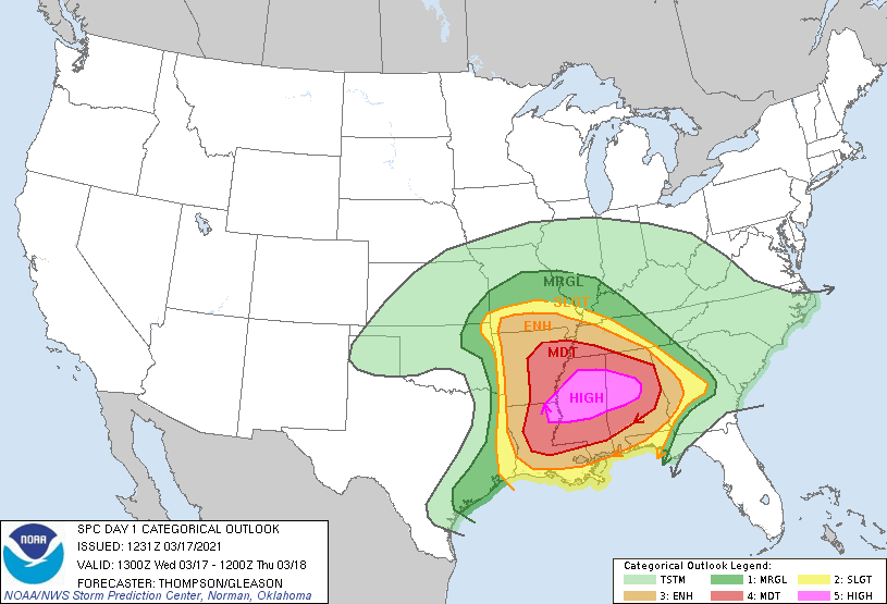
SPC AC 171231
Day 1 Convective Outlook
NWS Storm Prediction Center Norman OK
0731 AM CDT Wed Mar 17 2021
Valid 171300Z - 181200Z
...THERE IS A HIGH RISK OF SEVERE THUNDERSTORMS THIS AFTERNOON INTO
TONIGHT FROM NORTHEAST LA/SOUTHEAST AR ACROSS CENTRAL MS AND AL...
...SUMMARY...
A significant tornado outbreak, with long-track, intense tornadoes
is expected to begin this afternoon across parts of Louisiana and
Arkansas, and then spread eastward and peak this evening into
tonight across Mississippi and Alabama.
...Synopsis...
A compact, intense shortwave trough over the TX Panhandle this
morning will progress eastward over the Red River Valley today and
the lower MS Valley tonight. This midlevel trough will be preceded
by a surface cyclone that will move from northeast OK across
northern AR/southern MO to the confluence of the MS/OH Rivers near
the end of the period. This process will result in strengthening
mid-upper flow over the lower MS Valley, as well as increasingly
strong low-level southerly flow and moisture transport. The net
result will be a broad warm sector centered on the lower MS Valley,
capable of supporting multiple rounds of storms/supercells today
into tonight.
...Short-term, ongoing convection...
There are several zones of ongoing convection this morning, though
most of this convection is on the fringes of a broad warm sector.
The primary short-term threats will be focused with warm advection
storms, now rooted near the surface warm front, from southeast AR
across northern MS/adjacent southwest TN through about midday. More
than adequate deep-layer shear and SRH, in a slowly
warming/moistening environment, will support a continued threat for
all hazards with this convection through about midday. Farther
west, an extensive (but broken) band of convection extends from
northeast TX into western AR in association with a bore-like wave
propagating eastward in the warm sector. These storms will persist
through the morning, with primary threats for damaging winds and
large hail. Farther north, a loose cluster of elevated storms
continues to spread east-northeastward from northeast OK toward
southwest MO, in a zone of strong low-level warm advection with
MUCAPE of 1000-2000 J/kg. Despite the elevated nature of the
storms, there will still be the potential for downdrafts to reach
the surface with strong/damaging gusts through the morning.
...Primary tornado outbreak this afternoon into tonight...
The ongoing convection across eastern AR/western TN/northern MS will
tend to reinforce the surface warm front near the TN/MS border
through early afternoon. The northeast TX and eastern OK bands of
storms will overspread the Ark-La-Tex and the remainder of central
AR through mid-late morning, with the potential to produce damaging
winds, large hail, and a couple of tornadoes. In the wake of this
convection, some air mass recovery is expected across AR, back to
the surface cyclone near the AR/OK/MO border intersection by midday
to early afternoon. Thereafter, surface-based thunderstorm
development is expected along the wind shift from near Shreveport to
Fort Smith, and storms will spread eastward across AR/LA through the
afternoon/evening.
The destabilizing warm sector with warming temperatures and
mid-upper 60s dewpoints, will support MLCAPE up to 2000 J/kg, and
strengthening vertical shear will be favorable for a broken band of
supercells capable of producing tornadoes, large hail, and damaging
winds. A couple of strong tornadoes will be possible this
afternoon/evening across LA/AR.
Farther east, the most dangerous part of the severe weather outbreak
is expected to evolve today into tonight from central MS into
central AL. Here, there will be the potential for scattered
supercell development in the open warm sector by midday, in an
environment with MLCAPE near or above 2000 J/kg, effective bulk
shear near 50 kt, and effective SRH near 200 m2/s2. All hazards
will be possible with these warm sector storms during the afternoon.
By late afternoon and into early tonight, a low-level jet segment
will strengthen to 50-60 kt across MS/AL and the midlevel trough
approaches from the west, contributing to very strong low-level
shear (0-1 km SRH of 400-500 m2/s2). Buoyancy will be slow to
decrease after sunset and with eastward extent based on the
prevalence of upper 60s dewpoints, while very favorable wind
profiles will maintain the threat for long-track, intense tornadoes
with both warm sector supercells, as well as supercells within the
broken band along and ahead of the surface wind shift progressing
eastward across MS by early tonight. West central GA appears to be
the eastern edge of the primary severe threat area through tonight.
..Thompson/Gleason.. 03/17/2021
CLICK TO GET WUUS01 PTSDY1 PRODUCT
NOTE: THE NEXT DAY 1 OUTLOOK IS SCHEDULED BY 1630Z
CURRENT UTC TIME: 1328Z (9:28AM), RELOAD THIS PAGE TO UPDATE THE TIME
https://www.spc.noaa.gov/products/outlook/day1otlk.html
 = new reply since forum marked as read
Highlight:
NoneDon't highlight anything
5 newestHighlight 5 most recent replies
= new reply since forum marked as read
Highlight:
NoneDon't highlight anything
5 newestHighlight 5 most recent replies

crimsonandclover
(58 posts)It's too cool this morning in Huntsville for anything serious but that will change this afternoon. I check the radar about every 10 minutes.

catbyte
(34,403 posts)are already getting severe storms.
crimsonandclover
(58 posts)Hortensis
(58,785 posts)House of Roberts
(5,177 posts)That would be the most turbulent air, as the cold front arrives. There isn't anything on the radar after about 10am, for a good while, then there's a thin storm line in Texas that looks typical to produce the usual outbreak of warnings. We may see some storm creation in South Alabama middle of the day.
I'm also in Huntsville, by the way. They called off school today, and cancelled a lot of functions around the Valley.

Whiskeytide
(4,461 posts)... central Alabama - Tuscaloosa and B’Ham. Watching it closely.

Lars39
(26,109 posts)Seems it's a pretty big system heading our way.
exboyfil
(17,863 posts)My wife's one non-negotiable was the presence of a basement. I didn't grow up with a basement. She always had a basement because of growing up in Iowa (frost depth makes it a low variable cost to add a basement). Closest I have ever been to a tornado was in Tennessee. We spent that time in the basement.
Years later that community, Cookeville, had a horrible tornado that killed several people near where we had once lived. It that case a basement might not have made a difference because I think many were hit unaware.