General Discussion
Related: Editorials & Other Articles, Issue Forums, Alliance Forums, Region Forums
 = new reply since forum marked as read
Highlight:
NoneDon't highlight anything
5 newestHighlight 5 most recent replies
= new reply since forum marked as read
Highlight:
NoneDon't highlight anything
5 newestHighlight 5 most recent replies

hlthe2b
(102,271 posts)(though for the Sarah Palins of the world, who think Africa is a country, there may be little hope) 

progressoid
(49,990 posts)
central scrutinizer
(11,648 posts)nfm

Name Unpronounceable
(39 posts)map made up by a LIEberal.

treestar
(82,383 posts)It's always helpful to see something like that.

Jamaal510
(10,893 posts)Scuba
(53,475 posts)
Thanks for the other graphic okaawhatever. Much appreciated.


Walk away
(9,494 posts)
bvar22
(39,909 posts)That is WHY the IMF jumped on the the chance to piggy-back on the legitimate Arab Spring uprisings
to "remove" Gaddafi.
He was a major road block between the Global Banks and the Global Resource Extraction Corporations
and the riches of North Africa.
http://www.atimes.com/atimes/Middle_East/MD27Ak01.html
oldandhappy
(6,719 posts)Big chunks of the world. Africa's time is coming, but not yet. Wish I could be here for it.
fascisthunter
(29,381 posts)
okaawhatever
(9,462 posts)fascisthunter
(29,381 posts)okaawhatever
(9,462 posts)at first. You usually have to refresh to see it come up in picture/graphic form. Here on DU if you paste a pic you can click preview and it will show the pic/graphic if you did it right.
fascisthunter
(29,381 posts)
kentauros
(29,414 posts)
Motown_Johnny
(22,308 posts)
BumRushDaShow
(128,978 posts)

Ilsa
(61,695 posts)It isn't the US without the last two states.
Vashta Nerada
(3,922 posts)okaawhatever
(9,462 posts)
underpants
(182,803 posts)just kidding of course
NYC_SKP
(68,644 posts)Last edited Wed Apr 2, 2014, 08:31 PM - Edit history (2)
1. Infant Mortality:

2. Human Poverty:

3. Life Expectancy:

4. Female Life Expectancy:

5. And, finally, National Income:

Feel free to share.
Credit to http://www.worldmapper.org


cyberswede
(26,117 posts)That is amazing. 
NYC_SKP
(68,644 posts)WTH is going on with that?!
Typically, women outlive men.
FUCK!
child birth (women dying during) and sex selection both pre and post birth. I would be pretty sure of the first and somewhat sure of the second.
Spitfire of ATJ
(32,723 posts)mathematic
(1,439 posts)You're reading the graphic wrong.
http://www.who.int/gho/publications/world_health_statistics/EN_WHS2013_Part3.pdf?ua=1
NYC_SKP
(68,644 posts)
Scootaloo
(25,699 posts)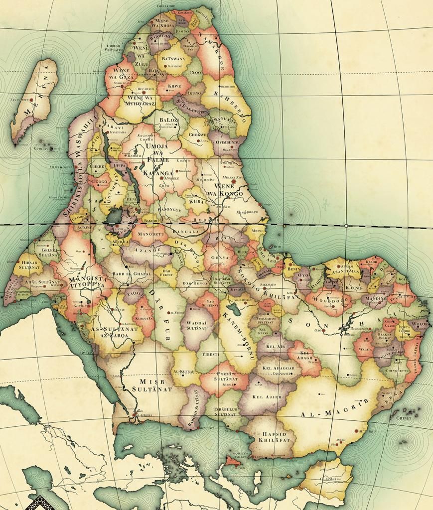
NYC_SKP
(68,644 posts)AKA the Greenwich Meridian AKA 0 degrees latitude, which runs through the Royal Observatory in England, among the most notorious colonists.
About the map:
http://imperialglobalexeter.com/2014/01/25/this-weeks-top-picks-in-imperial-global-history-4/

Scootaloo
(25,699 posts)If you're going to measure it, you have to start somewhere, though, there has to be a "zero" point. Might as well be Greenwich just as easily as it might as well not, really.
NYC_SKP
(68,644 posts)Was my point. Who creates the system gets to name where point zero is, this is true.

Nye Bevan
(25,406 posts)Anyone who refers to it as the Greenwich meridian is probably a racist.

cemaphonic
(4,138 posts)It has some odd ahistorical (for the 19th Century) aspects to it, such as the re-Reconquista in Iberia and Sicily. Also, I don't think that Songhai was anywhere near that big by then.
Still a neat map.

malaise
(268,997 posts)It's a magnificent continent.
Flying Squirrel
(3,041 posts)