Mali Islamist militants 'destroy' Timbuktu saint's tomb
Source: BBC
6 May 2012 Last updated at 11:49 GMT
Islamist fighters said to be linked to al-Qaeda have destroyed the tomb of a local Muslim saint in the Malian town of Timbuktu, officials and locals say.
The gunmen attacked the shrine and set it on fire, saying it was contrary to Islam, according to the official.
Tuareg rebels and Islamist fighters took control of Timbuktu, a UN heritage site, after a military coup in March.
Unesco said the town's capture could endanger its "outstanding architectural wonders" .
[font size=1]-snip-[/font]
Read more: http://www.bbc.co.uk/news/world-africa-17973545
 = new reply since forum marked as read
Highlight:
NoneDon't highlight anything
5 newestHighlight 5 most recent replies
= new reply since forum marked as read
Highlight:
NoneDon't highlight anything
5 newestHighlight 5 most recent replies
provis99
(13,062 posts)they never create; destruction is their aim in life. Barbarians...

Marrah_G
(28,581 posts)I hate seeing religious extremists destroy irreplaceable history.
may3rd
(593 posts)But enjoyed blowing up statuary of other cults without batting an eye
saras
(6,670 posts)
grantcart
(53,061 posts)Marrah_G
(28,581 posts)Amazing!!!!!!
Thank you for posting that. I love history and read/watch as much as I can.

LibertyLover
(4,788 posts)but it is an amazing repository of old books. It was a place of learning for many years. Some of the architecture is stunning. Here is a Wikipedia entry on it.
http://en.wikipedia.org/wiki/Timbuktu
I can't remember if it was a "60 Minutes" program or a National Geographic one I saw on it several years ago, but it was sad. Many of the libraries of books are rotting away because their custodians cannot afford to preserve them.
Marrah_G
(28,581 posts)I swear I learn something new on DU every day.
grantcart
(53,061 posts)LibertyLover
(4,788 posts)Thank you!!! Excellent read.
riderinthestorm
(23,272 posts) So ignorant, so terribly wrong.
Archae
(47,245 posts)"We don't like it, so no one else can like it either!"

DCBob
(24,689 posts)This is sickening. Such waste, such ignorance. Fools.

sakabatou
(46,099 posts)cosmicone
(11,014 posts)It will be sad to see it destroyed and change.
Before the roads and jeeps, it took 2 days of a camel ride from Bamako in a caravan to go there and it was awesome.
Fundies of all sorts should destroy each other instead of property.

demosincebirth
(12,825 posts)4th law of robotics
(6,801 posts)
Odin2005
(53,521 posts)Those BASTARDS!!! 
closeupready
(29,503 posts)or the year before. He's not from the US, and hadn't been as exposed to the history of WWII, as Americans and Europeans are.
At one point during the documentary, watching footage of Germany's destruction, he commented that it's sad that so much of the historical architecture was destroyed.
I responded that I agree, but that like people, if cultures become suicidal, there's not much that anyone can do to stop them, and that the onus for that self-destruction lies with them, not anyone else.
I see these kinds of stories similarly.
grantcart
(53,061 posts)happyslug
(14,779 posts)Both per-Roman Carthage, when trade was done by Horses, or Roman Carthage which saw the slow switch to Camels do to the Sahara desert becoming dryer.
http://www.livescience.com/4180-sahara-desert-lush-populated.html
http://oceanworld.tamu.edu/resources/environment-book/desertificationinsahel.html
http://web.me.com/uriarte/Earths_Climate/11._The_Holocene.html
Horses were the preferred way to do trade, but that seems to have ended about the time of the birth of Christ do to the increase aridness of the Sahara. The Sahara before about 5000 BC was a Savannah not a desert, but from that time forward has slowly become dryer. It was still wet enough for horses till about the time of Christ, but shortly after that date it became to dry for most horse draw wagons to cross the increasingly dry desert. Camels were introduced about the time of Christ to "Solve" this problem, but apparently used for a Camel riding border guards for the first 200 years, then trade after 200 AD, but the real boom in camel usage was after the Arab Conquest after 750- AD.
Please note, some of the above comments is based on very limited historical documentation. For example, we know Carthage main source of Wealth was its trade with area around Timbuktu, but it is unclear how much of that survived the destruction of Carthage at the end of the Third Punic War. On the other hand we know the wealth was still available for Caesar re-founded Carthage about 80 years after it had been destroyed, and it quickly became the Second largest city in the Western Empire (Behind Rome itself, and behind Alexandria Egypt, if you consider the entire Roman Empire, i,e, Carthage was the third largest city, behind Rome and Alexandria).
The Arabs destroyed Carthage but its harbor had become marginal by that time and Tunis was more then able to replace it (Tunis had always been Carthage port) and again it boomed till the Portuguese found out how to said to the "Gold Coast" of Africa (Nigeria and its neighbors) and bypassing the entire trans-Sahara trade system. Once trade went by ship, Timbuktu became a back water that most people have heard of, but no one ever went to.
grantcart
(53,061 posts)But I still don't understand of why the logic of Timbuktu's location.
It doesn't seem like a logical trade point.
Is there something I am missing?
happyslug
(14,779 posts)From Carthage to Timbuktu, is the quickest way to travel between the Niger River Valley and the Mediterranean Sea. The Niger is the 11th longest river in the world
http://www.socialstudiesforkids.com/articles/geography/nigerriver.htm
http://en.wikipedia.org/wiki/Niger_River
http://www.fao.org/docrep/W4347E/w4347e0i.htm
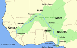
Notice where Timbuktu is on the Niger, It is at the point where the NIGER River is the closet to the Mediterranean Sea, it is also a short walk to the Volta River system and the Senegal River Systems (The other two main trade routes in West Africa).
A tributary flows in the direction of Carthage from Timbuktu, but it is a non-navigable tributary, but once at Timbuktu, you can get a boat and float downstream to Nigeria, or sail upstream to Guinea (and then a short walk to the Senegal River). And it is a relatively short walk to anywhere else on the "Gold Coast" of Africa (Short walks to the Volta River system). Gold was produced on the Gold Coast (and later slaves) and Ivory. Europe traded salt, plentiful in Tunisia (and later Spain) for gold and Ivory and later slaves.
Remember, this route started as a HORSE wagon route, later converted to Camels as the Sahara dried out, thus following a river was preferred even if it was dried out most of the time.
Furthermore, movement south of Algeria and Morocco, had to go over the Atlas mountains, thus avoided if possible,
More on the Atlas Mountains:
http://en.wikipedia.org/wiki/Atlas_Mountains
Going south from Tripoli Libya in the direction of Timbuktu was prevented by the Tibesti Mountains, while no where at high as the Atlas Mountains, it is some of the dryest areas on the planet. People avoid it if at all possible. The only place worse is the Quttara Depression just inside Egypt on the Libyan-Egyptian Border. No body lives there (140 degrees in the shade, and they isn't any).
More on the Tibesti Mountains.
http://en.wikipedia.org/wiki/Tibesti_Mountains
More on the Qattara Depression
http://en.wikipedia.org/wiki/Qattara_Depression
In Southern Tunisian has a gap between these two sets of mountains, that is watered by the Atlas Mountains. Thus you have Lake Chott el Djerid. It is dry in the Summer, but a salt lake in the Winter, thus you have some fresh water in the area reaching the lake in winter.
http://en.wikipedia.org/wiki/Chott_el_Djerid
Thus the trade route was from Carthage into the middle of what is now Eastern Algeria (Avoiding the Atlas Mountains). then south to Timbuktu (Avoiding the Tibesti Mountains of Southern Libya and Northern Chad). It is the best LAND ROUTE between the Mediterranean and the Niger River Valley, thus was used for centuries, until a sea route was found by the Portuguese in the 1400s.
Please note the reason Ships did NOT go south of Morocco prior to the 1400s was the Equator is in Morocco, thus south of Morocco you lost the North Star. Sailors had used the North Star for thousands of years and did NOT want to sail anywhere where it was "gone" for then they had no reference point to determine where they were. Henry the Navigator, a Prince of Portugal kept sending ships south. Sailors would go a little bit further south each time, given the previous trip had come back (This is the start of the use of widespread use of the Compass). Finally one ship turned the corner and sailed into the Gold Coast, and brought back a fortune. By the death of Henry, Portugal had started to mint vast quantities of gold coins do to its new wealth.
Henry the Navigator was the Head of the "Order of Christ", a group formed when the Pope dissolved the Knights Templar. Technically all of the Assets (and Knights) of the Templars were to go to the Hospitaliars, but the Kings of Spain and Portugal opposed that, thus formed a new order from the Templars located in Spain and Portugal. Thus the wealth of the Templars paid for Henry's expeditions around Africa.
http://en.wikipedia.org/wiki/Henry_the_Navigator
Just a note on why the trade route went the way it did, and why it lasted so long (No way to tell North or South without being able to see the North Star, thus the land route was the only possible way till the invention of the compass) and died so quickly (Compass and sea trade was more efficient).
Side note: There is a report of an Egyptian trip around Africa, but it lead to nothing:
http://www.touregypt.net/featurestories/nechoafrica.htm
grantcart
(53,061 posts)Now when do we have to sit for the test and will there be a map test along with the history test? Will there be essay questions or will it be multiple choice.
happyslug
(14,779 posts)And the answer is EVERYTHING. Geography determines not only where you fight, but how and often why. Egypt, for example will go to war over any attempt to cut off the Nile. The US attitude to Cuba is related to how close it is to New Orleans (And if you wanted to take over the US, the first two cities you need to take, are New Orleans and Quebec, once you have those two cities, you control most of the trade between the Rockies and the Appalachian Mountains).
Here is some example of how Geography determined WHERE a war was fought:
Moscow is the key city of Russia, control Moscow, you control Russia. Napoleon and Hitler knew this and is the reason both marched on Moscow. Napoleon's problem was once in Moscow, the Russians had burned the city and all the food and since he had no way to get food for his soldiers, he had to retreat. Hitler's problem was NOT a lack of Food, he had food for his men, but he NEVER took Moscow.
Paris is NOT only the Capital of France, but its key, if you have Paris, you have France. On the other hand, the lost of Washington, New York or Philadelphia (All had been US Capitals) is just the lost of a meeting place, the American People can meet elsewhere and still fight onward (as it did with the Lost of Philadelphia in the fall of 1776 and Washington DC in 1814). The lost of Washington, New York or Philadelphia will NOT be fatal to the US, but the US will nuke the world over New Orleans and Quebec.
Britain is an island, and thus more concerned about its Fleet then its Army. Ireland is the richest agricultural part of both Ireland and Britain, but has no real center, thus must be conquered county by county, as the British did under Elizabeth I, Cromwell in the 1600s and how the IRA freed Ireland from British rule during the Irish uprising of 1921 (i.e. Dublin is important, but only as a base to take over the rest of Ireland, NOT to control the rest of Ireland).
Yorktown Virginia is the base you need to have to conquer the rest of Virginia, but since it is surrounded by higher lands on all sides, you need more men to hold it then to take it. Thus Cornwallis only went to Yorktown on the promise of additional troops from Clinton whose forces were in New York City, but when they failed to break through the French Fleet, Cornwallis was doomed. In 1862-1865 the North Kept a Massive amount of Troops at Yorktown for the same reason, you need more troops to hold it then to take it. The North made sure there were plenty of Union Troops around Yorktown between 1862 and 1865 (The same with the Alamo, for the same reason, thus Sam Houston told Travis to destroy the Alamo and abandon the death trap).
Why are we bombing Pakistan? The US Supply line for out troops in Afghanistan goes through Pakistan. You do NOT bomb your own supply line (and do NOT bomb people along it, do to fears you will make a mistake and end up recruits for the other side).
Cut off the enemy supply line if possible, the failure to do this in Vietnam was the key to US defeat. The enemy supply line ran along the Mekong River in Laos and Cambodia. The US tried to bomb that supply line out of commission, but the Viet Cong made every effort to keep that supply line open. The US dared not send in US Troops into southern Laos for fear of Red Chinese intervention, but by the time the Mekong River turned East on Phnom Penh it had run the entire length of the border between Cambodia and Vietnam (Both North and South). The Mekong starts in China, flows into Laos and Cambodia and finally into Southern Vietnam. Supplies between North and South Vietnam went via the Ho Chin Minh Highway on both sides of the Mekong (As while as on "Junks" on the Mekong). The US tried to stop this supply line with a bombing campaign, a special forces campaign, hiring Laotians to fight to destroy the supply line, all failed. This meant the Viet Cong had supplies while it was fighting in South Vietnam. The rule in Guerrilla warfare is if you can NOT cut off the supply line of the Guerrillas, give up or make a deal. The US failure to cut off the supply line doomed the US efforts in South Vietnam (And similar situation occurred in Afghanistan during the Russian occupation, the Russian's failure to cut off supplies from Pakistan meant the Russians could not win, so they finally withdrew).
HERE IS SOME EXAMPLE OF GEOGRAPHY DETERMINING WHY A WAR WAS FOUGHT:
Yes, Geography determines how, when and why wars are fought. Rome attacked Carthage in the Third Punic War for control of the Gold Trade with the Niger River Valley. Caesar attacked Gaul, for the gold deposits in Gaul he could loot. Hitler attacked Russia not only for the Wheat fields of Russia and the Ukraine, but the oil fields of Russia. Europe fought over the Sugar Islands of the West Indies in the 1600s and 1700s more then what was to become the US, for in the 1600s and 1700s those sugar islands were more valuable then the American Colonies (The Sugar beat and its sugar killed off the huge profits of the West Indies Sugar Plantations after 1800s, so by the 1800s the islands became poor colonies of Europe not the prize to grab they had been in the 1600s and 1700s). Sugar also explained the Slave Trade of the 1600s and 1700s, some one had to work in those Plantations, and if you were smart you did your best to avoid that fate.
Here is some example of Geography determining HOW a war was fought:
During the Cold war the US developed electronic anti take missiles to replace 1950 era recoil-less rifles. The problem was the TOW and the DRAGON anti-tank weapon could NOT work in cold weather (I believe the cut off was 20 degrees below Zero). Thus in Alaska and other northern areas, the US uses to this day, 1950 era recoil-less rifles (The 106mm and the 73 mm Recoil-less rifles).
The US sent in Vietnam in 1964 its air mobile 101st Division with Helicopters. Why? It was easier to ship the helicopters in by using some of our old WWII carriers then to ship in tanks, given the lack of a decent port in all of South Vietnam (Under French rule the main port was Haiphong next to Hanoi, both in North Vietnam). IT took the US from 1965 to 1968 to build a port that could take in the supplies needed by the South Vietnamese Army to train, let alone fight (Rough rule, a soldier should train three times the time he is actually fighting). Thus the US had to send in US troops, for that was easier on the supply line then getting the supplies needed to upgrade the South Vietnamese Army. After 1968 US forces started to be pulled down, but the US decided to keep the Tanks units it had send it and send home the leg infantry units. The reason for this was simple, the US had finished the harbor it needed to supply and train the South Vietnamese Army AND maintain US Armor units in Vietnam. The Lack of a Harbor (Geography) forced the US to send in leg infantry rather then Armor Infantry. Leg Infantry did NOT need the same supply line as an armor unit do to its lack of heavy armor.
Germany had made all of its Cavalry forces Armor by 1939, but when it attacked Russia it ended up in an area where it needed Cavalry, thus the SS became the sole Germany Cavalry unit in the German Army, fighting in the Pripyat Marshes. It was an area where no armor could go, so cavalry was used. As the German army became more and more involved in Russia, they ended up recruiting Russian Cossacks as Cavalry, for it was the most effective force in areas without roads (Pripyat marshes is the best known area in Russia but others exist). As the German Army came close to Moscow in December 1941, it started to turn in its trucks for horses, for the simple reason the horse were able to move in the mud and snow of the Russian winters, while the trucks could not (as the war went on the German army turned more and more to the horse to haul supplies, do to lack of fuel then any other reason, by 1942 a German Infantry unit on the Offensive received only 10% of its pre-war allocation of fuel, the lack of fuel is also a factor in why and how the Germans fought the War).
The US did NOT field its Cavalry forces (Except the 26th Cavalry Regiment, Philippine Scouts in the 1941-1942 Japanese Conquest of the Philippines) for the simple reason a US Cavalry forces, do to its horses, food and care for the horses, took up as much room in shipping as an Armor Division.
During the Japanese attack on Malaysia, which target was Singapore, The Japanese seeing the terrain he was to fight in, knew he needed to be able to out flank the British Defenders. To do so he needed a method to be able to run around any defensive position the British put up along the length of the island. This had to be faster then infantry on foot, but within the shipping restrictions of the Japanese navy AND be able to get around in heavy jungle. When the German High Command was asked to prepare a plan, the German's did so. The German Plan was for a 18 month march given the restrictions the Japanese were facing. The Japanese commander thank them, for that is what Army Staff do all the time, then came up with his own plan. The key was the use of bicycles. The bike permitted the Japanese soldiers to go faster and further and carry more supplies then if he was on foot. This permitted wide swing around British defensive positions. The British would find themselves by passed every time they had set up a defensive positions, but restricted to roads do to their dependence on Trucks. Within six weeks the Japanese were outside Singapore and Singapore fell to the Japanese land forces.
The Vietcong were also to use bicycle on the Ho Chin Mind Trail. When the Trail was actually bombed, the supplies would still go forward, on bicycles to the next area of open road. 1000 pounds on a bike (No one road the bike south, pushed them instead). Jungle canopy prevented the US from seeing this movement and how ineffective the bombing of the Ho Chin Minh trail was.
Going back in History, the British made almost no use of Cavalry in the American North during the American Revolution, do to a lack of horses and the fact the Northern Colonies made an effort NOT to permit any horses to get to the British (And that it took six weeks to go from Britain to American by Sailing ship, thus expensive and hard to ship horses from Europe). Now, in the South the British did man an effective Calvary forces, but once it was destroyed at the battle of the Cowpens, the British did not have the horses to remake it, thus Cornwallis on his march into Virginia had no effective Cavalry force available.
When the US Civil War Started everyone thought in would be a infantry fight and it was for the first year or so, then both sides slowly build up their cavalry forces. The South First, but then the North. The North was late to adopt more horse mounted men, but once it did so, did so in larger numbers then the south. By the end of the War 1/3 of the Union army was horse mounted, When the war started that was less then 10% of the forces raised. The reason for this is the distance involved in fighting in America forced both sides to move more men quicker then you could do so on foot. Thus geography force the increase use of horse mounted men (Through it should be noted, most Calvary engagements in the Civil war, the Cavalrymen fought on foot, they horses were just a way to get to the battle NOT something to fight the battle on). One Pennsylvania unit even formed as a Lance unit (i.e. armed with a 18 foot lance instead of a saber, after two years this was dropped, the lance kept on getting caught on the trees and the lancers were given rifles).
When Attila the Hun was defeated at the Battle of Châlons in 451, when he was defeated he retreated to his camp and took a last stand. The Romans left him go, feared the lost of to many men in storming the camp. The significance of this was the retreat to a Camp was a German tactic of the Time period when defeated in battle, On the Steeps where the Huns came from the traditional tactic was to disperse and run in all directions. Why the change in Tactic? The answer is simple, the Germans had adopted their tactic given the Rivers and Mountains of Germany. hard to escape, the mountains channel people and rivers block escape routes. Thus in Germany it was better to retreat to the Camp and take a final stand. In the Steeps, it was one flat open country, people could run in ALL DIRECTIONS. any enemy would have to follow in all directions. The problem is sooner or later some of the defeated forces will find themselves no longer being chased, or if chased by a smaller force of the enemy. Either way the detachment can survive. Geography directed the two tactic. The mountains and Rivers of Germany forces defeated forces to take a stand, to run away, meet not to run to far, and then in restricted areas so the victors could always maintain superiority in numbers. On the Steeps, the defeated forces could run in all directions, and enemy would have to disperse they own forces to chase them. Thus in the Steeps the best way for some soldiers to survive is for all of the survivors are to run in all directions (Native Americans seems to have adopted this tactic in the Great Plains for the same reason).
Even when a War is fought is governed by Geography"
Russia has only been conquered twice, once by the Mongols and the second time (and only for the winter and only Moscow) the Poles). Both follow the same rules, high speed conquest (horses mounted forces in both cases) AND in a winter campaign (The rivers, marshes and Lakes of Russia are frozen over, so Russia is one big frozen plate, unlike in Summer where it is divided into small sections by its many Rivers, Lakes and Marshes.
In Vietnam, the US depended on Helicopters, moved its forces in Laos during the dry season, taking huge areas from the North Vietnamese. In the wet season, the Helicopters could not move do to the rain and cloud cover, so the North Vietnamese then proceeded to retake what the US had taken, using leg infantry,
Present US doctrine calls for an massive Air Attack starting on or near a new moon, the US technology advantage permit the US to attack fixed points without having to see them. This continues for six weeks, i.e. a Full Moon, another New Moon, then a Second full moon, for ground forces, need the Full Moon to see holes and other obstacles in the road. Night vision devices tend to miss these for most have no light in them at all, and thus the nigh vision device does not work. Thus ground forces want a full moon.
In India, the British tried they best to do all the fighting during the dry season, during the wet season it was hard to not only move the troops but also the supplies for the troops.
In Afghanistan, the Taliban likes to attack after the harvest of its Winter wheat (April and May) but before the planting of the crop in the fall (September October), Thus the Taliban are starting their fighting right now, will end in about four months when they will sit out the winter. The tries to store up its supplies this time of year for come winter the passes from Pakistan to Afghanistan tend to become snowed in. The US prefer Winter campaigns for the Taliban are snowed in and thus easier to find and destroy.
Just pointing out that Where, why, how and even when a war is fought is often governed by geography. Thus the answer to the question is "everything".