Welcome to DU!
The truly grassroots left-of-center political community where regular people, not algorithms, drive the discussions and set the standards.
Join the community:
Create a free account
Support DU (and get rid of ads!):
Become a Star Member
Latest Breaking News
General Discussion
The DU Lounge
All Forums
Issue Forums
Culture Forums
Alliance Forums
Region Forums
Support Forums
Help & Search
Tropical Storm Danny Forms in Atlantic, Expected to Become Hurricane
Source: NBC News
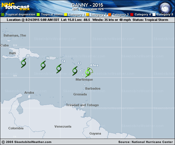
A tropical depression in the Atlantic Ocean east of the Caribbean strengthened Tuesday to become the season's fourth tropical storm, and it is expected to become a hurricane in two days, forecasters said.
Tropical Storm Danny is about 1,600 miles east of the Windward Islands and was moving west at around 12 miles per hour, the National Hurricane Center said.
It had maximum sustained winds of 40 mph and is expected to strengthen to a hurricane by Thursday, the Hurricane Center said.
<not much more>
Read more: http://www.nbcnews.com/news/weather/tropical-storm-danny-forms-atlantic-expected-become-hurricane-n412021
 ?317129205
InfoView thread info, including edit history
TrashPut this thread in your Trash Can (My DU » Trash Can)
BookmarkAdd this thread to your Bookmarks (My DU » Bookmarks)
2 replies, 1528 views
ShareGet links to this post and/or share on social media
AlertAlert this post for a rule violation
PowersThere are no powers you can use on this post
EditCannot edit other people's posts
ReplyReply to this post
EditCannot edit other people's posts
Rec (5)
ReplyReply to this post
2 replies
 = new reply since forum marked as read
Highlight:
NoneDon't highlight anything
5 newestHighlight 5 most recent replies
= new reply since forum marked as read
Highlight:
NoneDon't highlight anything
5 newestHighlight 5 most recent replies
= new reply since forum marked as read
Highlight:
NoneDon't highlight anything
5 newestHighlight 5 most recent replies
Tropical Storm Danny Forms in Atlantic, Expected to Become Hurricane (Original Post)
jpak
Aug 2015
OP

starroute
(12,977 posts)1. More from Jeff Masters
http://www.wunderground.com/blog/JeffMasters/comment.html?entrynum=3075
The 11 am EDT outlook from NHC brings TD 4 to hurricane strength by Friday morning and to Category 2 strength (sustained winds of 100 mph) by Saturday. This long-range forecast is consistent with the statistical models that show more skill than dynamical models at intensity prediction beyond 3 days. Of the two dynamical models most trusted for intensity forecasting, the HWRF has consistently called for TD 4 to develop into at least a strong Category 1 hurricane, while the GFDL has failed to develop TD 4, so the recently upgraded HWRF may end up closer to the mark in this case. Intensity prediction is still very challenging, so it is quite possible that TD 4 could be substantially weaker or stronger by this weekend than the current NHC forecast indicates. Over the last two years, the average 5-day error in NHC intensity projections was around 15 mph, or a bit more than half a category on the Saffir-Simpson Hurricane Wind Scale. This is substantially better than prior years: between 2000 and 2010, intensity errors at 5 days averaged more than 25 mph.
TD 4 is many days away from any threat to the Leeward Islands. Most of the dynamical track models keep TD 4 moving west to west-northwest at a modest pace. The model consensus keeps TD 4 east of 50°W longitude until this weekend, when a building ridge to the north of TD 4 should help push it at a faster rate toward the islands. By that point, the system would draw on oceanic heat content that gradually increases along its path. It is far too early to predict with any confidence how much of a threat TD 4 might pose to the United States next week. Only a small change in trajectory this far out can have big implications for the track many days from now, and it remains to be seen whether dry air and dust will keep TD 4 from maximizing its potential for development.

Gothmog
(145,243 posts)2. It is way too early to be worried and yet I am