The DU Lounge
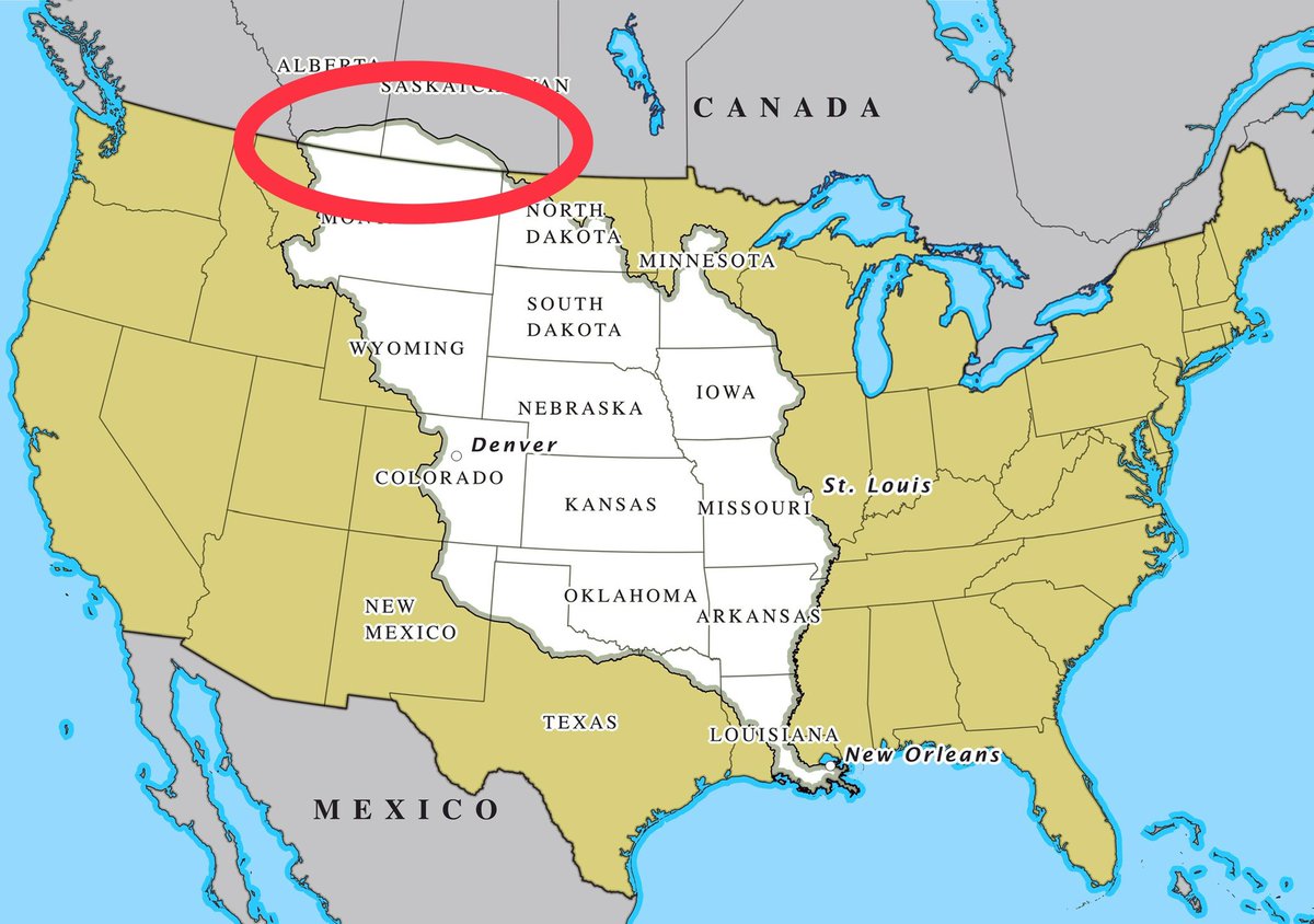
Related: Culture Forums, Support ForumsHere's a map of the Louisiana Purchase. What happened up here? Did Canada ask nicely or something?
I want it back. War is on the table.
Link to tweet
 = new reply since forum marked as read
Highlight:
NoneDon't highlight anything
5 newestHighlight 5 most recent replies
= new reply since forum marked as read
Highlight:
NoneDon't highlight anything
5 newestHighlight 5 most recent replies

comradebillyboy
(10,175 posts)
TheRealNorth
(9,500 posts)There was some disagreement between us and the British about where the border was. We eventually negotiated the Webster-Ashburton Treaty and the Oregon Treaty.

Wounded Bear
(58,717 posts)
They kind of just drew that line west from the Minnesota region, excepting Lake of the Woods, of course.
Ocelot II
(115,868 posts)And we got to keep it when the error was finally discovered. https://www.minnpost.com/mnopedia/2014/02/story-behind-minnesotas-weirdly-shaped-northern-border/
Wounded Bear
(58,717 posts)But that wasn't an error per se. They just drew the border strait out into the Strait of Georgia.


CincyDem
(6,387 posts)Not sure how that worked but it included England and Spain in the deal making that defined the 49th parallel as the northern US border. Personally, I'm much happier having a piece of the coast vs. more tundra in the middle of the country.
The Roux Comes First
(1,300 posts)Presumably round about the time of the "Pig War" in the San Juans, was likely preferable to keeping that stretch north of Montana. But it is a serious misnomer to call it a bunch of tundra. At the very least it likely includes what is now the Canadian counterpart of our Glacier Park, Waterton Lakes, and some fabulously scenic territory. Your tundra is a wee bit further north.
Wounded Bear
(58,717 posts)CincyDem
(6,387 posts)And it was snowing like crazy. My spring travel wardrobe was seriously underpowered.


Cracklin Charlie
(12,904 posts)Does anyone know where we left that receipt?
Gore1FL
(21,152 posts)

Historic NY
(37,453 posts)British gave Washington - Oregon - Idaho to the United States along the 49th Parallel in Aug 1846 .
Pres. Polk campaigned, whipping up war over the border all the way up the coast. The British prepared to do battle.
Wounded Bear
(58,717 posts)We had a joint occupation agreement with what is basically WA-OR-ID-BC for a while with England and Spain. Spain never really put any major effort into the region. The Americans and British, however, wrangled over the fur trade for a couple of decades, and the lumber, of course. Some of those tall firs make pretty good masts for the Navies.
doc03
(35,378 posts)Response to mahatmakanejeeves (Original post)
malthaussen This message was self-deleted by its author.
