Michigan
Related: About this forumRunning out of room to put snow here in the U.P.
Some of the streets in town are now one lane. Snow banks are higher then the roof of the vehicle in spots and at stop signs, I have to drive well out into the intersections to see if there is on coming traffic. The snow was over 4 feet deep at the end of the driveway and I pushed my snow blower to its limits in clearing that out.
There are reports of roofs caving in from the weight of the excessive snow and there's supposed to be another storm coming next weekend.
 = new reply since forum marked as read
Highlight:
NoneDon't highlight anything
5 newestHighlight 5 most recent replies
= new reply since forum marked as read
Highlight:
NoneDon't highlight anything
5 newestHighlight 5 most recent replies

Siwsan
(26,260 posts)The past few years we have had some'Up North' scale snow accumulations, but this year ice and wind have been bigger issues than snow. I think our total accumulation, so far, is about what we got in one big storm, from the past few years.
I guess more is on the way, but every weather site I check has a different forecast - somewhere between 1 and 7". 
Take care! Spring can't be THAT far off!!

Kaleva
(36,295 posts)That is, till the end of January.

mahatmakanejeeves
(57,425 posts)Snow, high winds predicted to make travel ‘impossible’ in some areas today; record for wettest February likely to be broken
FRONT PAGE NEWS
FEB 24, 2019
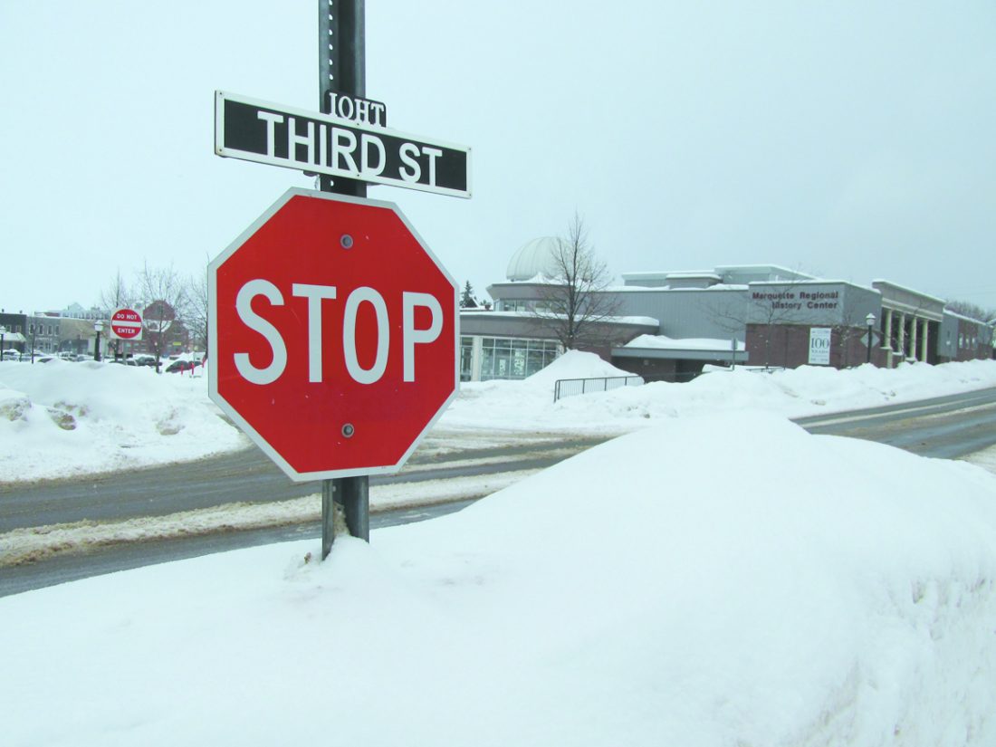
A stop sign peaks out of a snowbank along South Third Street in Marquette Saturday. Snowfall on Saturday preceded today’s major winter storm, which is predicted to bring the highest wind speeds observed this season in the area, along with over a foot of snow in parts of Marquette County. Officials from the National Weather Service recommend staying off the roads if possible, as whiteout conditions could occur in some places today. (Journal photos by Cecilia Brown)
MARQUETTE — A powerful winter storm is expected to dump heavy, wet snow and bring intense winds to Marquette County and the western half of the Upper Peninsula today, following a separate storm that brought snow to the area Saturday, according to the National Weather Service.
The storm that arrived Saturday was “just a precursor to what’s to come later on,” said Jordan Wendt, a meteorologist at the National Weather Service office in Negaunee, as forecasters expected to see a break in snow Saturday afternoon and evening before today’s storm.
“Things will really start to ramp up around 1 a.m. (today) and the bulk of the snow that we’re kind of expecting should fall between 1 a.m. and 7 a.m.,” Wendt said. “There’s a few spots in that timeframe that could pick up at least 10 inches or so, especially in the highlands in Marquette and Baraga counties.”
As of Saturday evening, there is a winter storm warning in effect from 10 p.m. Saturday through 1 a.m. Monday.
....
For the updated information on the storm and current conditions, visit www.weather.gov/mqt/
Cecilia Brown can be reached at 906-228-2500, ext. 248. Her email address is cbrown@miningjournal.net.
CentralMass
(15,265 posts)we had to stop at a hotel in greylock or gaylord for the night because of the snow on one trip when we were bringing my brother up. It was a Holiday Inn or some chain and there was an adjacent McDonald's (and not much else). This was in 78 or 79. By morning the snow had drifted and blocked our door. We had to call the office and have then clear it for us.

handmade34
(22,756 posts)this is my front door and windows...can get out my back door... but really don't want to 


CentralMass
(15,265 posts)Kaleva
(36,295 posts)WestMichRad
(1,320 posts)The snow mtns won't last forever, even though it may feel like it right now. Was in the Keweenaw the winter of '79-80 when we got a MASSIVE amount, measured over 360" (fresh snow) in one location. It covered EVERYTHING - small trees and buildings, many road signs, all outdoor mailboxes... cars and driveways, frequently. 'Tis quite a pain!
It's quite unnerving to drive INTO the intersection to see if any traffic is coming!