Pennsylvania
Related: About this forumTurzai/Scarnati map
Here's GOP designed new map that had no input from Dems or rank-and-file Rs. Gov Wolf will review it.

 = new reply since forum marked as read
Highlight:
NoneDon't highlight anything
5 newestHighlight 5 most recent replies
= new reply since forum marked as read
Highlight:
NoneDon't highlight anything
5 newestHighlight 5 most recent replies

blue neen
(12,321 posts)Why were Democrats shut out from this process?

BumRushDaShow
(129,053 posts)Interesting.
Since they waited this late, I expect others have their own versions ready should Wolf reject this.

Freddie
(9,267 posts)Instead of Goofy kicking Donald Duck, but still wrong. Please reject.
BumRushDaShow
(129,053 posts)where on average there are about 600,000 - 700,000 people per congressional district and most of the counties here in PA are rural, with 36 of the 67 counties having < 100,000 people.
What they had done before was to carve around high-minority population (smaller) cities in the east and then take those cities and put them (either whole or spit up) in other districts that would dilute them with heavily rural populations several counties away. In some cases, even doing that still meant very close party registration populaces... But then that's when Turzai attempted the Voter ID crap to essentially kill the minority smaller city voters (although fortunately that whole thing was thrown out as an unconstitutional "poll tax" due to the cost requirement to obtain a birth certificate).
So this will be tricky to do to be done right. You don't necessarily want to concentrate districts in the urban areas in order to minimize an urban vote with a lesser number of seats and maximize the lesser population areas so they get more seats.
Fortunately, according to the LWV rep who attended my telephone town hall on this subject, there is now quite a bit of demographic and other informational data available about the voting populace and there is software out there that can get very granular with that data for use in these types of maps. So maps meeting the criteria are more do-able than in the past.
It's just that we have this tight timeframe to get it done so it goes into effect for THIS YEAR'S election.  And we'll go through this all over again after the 2020 census, but hopefully the state will have a process that is non-partisan to do the lines.
BumRushDaShow
(129,053 posts)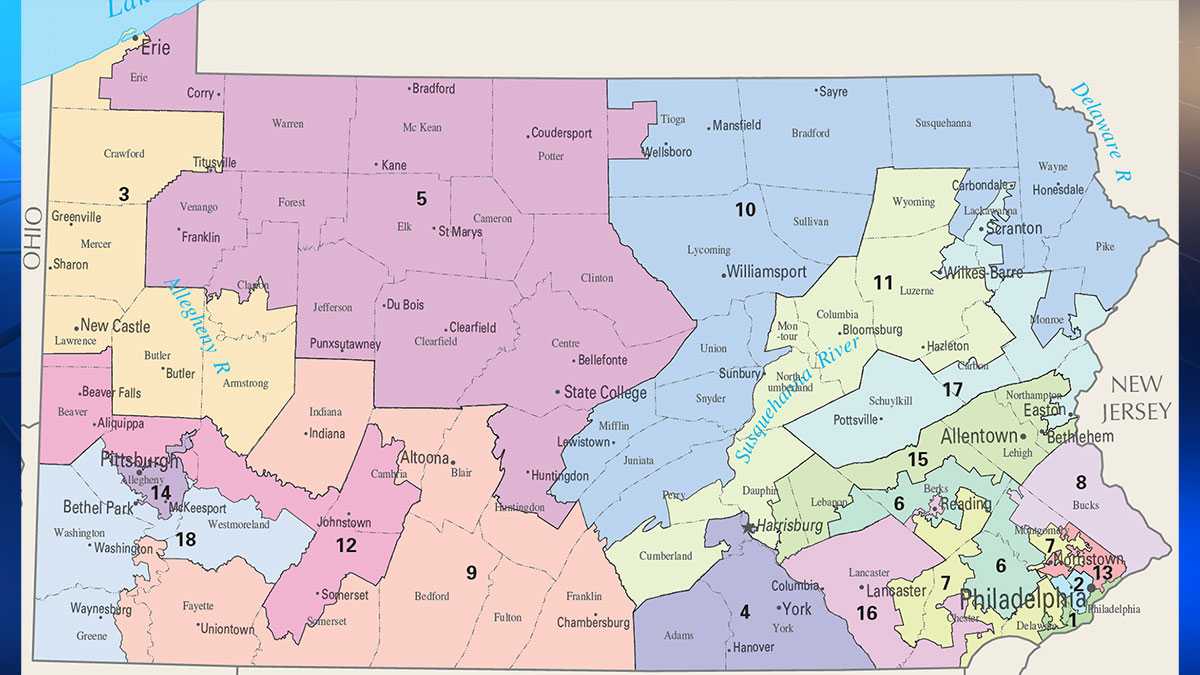
VS new map -

modrepub
(3,495 posts)Looks like there would be at least 5 Dem reps with this map. They've divided the Harrisburg area up weird; the lower part of Dauphin County gets grouped in an area that stretches up to Wilkes-Barre instead of combining with Cumberland; the east and west shores would be split up but that's probably how they want it.
My main complaint about any map for PA is the Repubs in the hinter lands of the state would be in safe seats and therefore probably be more senior than any more moderate Repubs from the Philly suburbs. Another gripe I have in general is that most of the state has declining population but those ares will be the Republican areas that are most safe and therefore get to guide policy and filter more resources to themselves. Would love two things to happen. 1) the majority of taxes to stay local; you want to live in the hinterlands then you figure out how to pay for your own services without taking other people's tax money. 2) top two candidates in the primary get to run in the general election. A bit unorthodox but at least there will be competitive races (even if it's just one party) and there will be more legislative turnover (the seniority thing bothers me because in PA its the low economic areas that have the control of state finances in stead of the areas actually generating tax revenue).
BumRushDaShow
(129,053 posts)who lives in Montgomery County. Montco is the 3rd largest county population-wise in the state (behind Philadelphia & Allegheny) and is 2nd wealth-wise, yet they maintain Montco as being split up 4 ways and by itself, it is a purple to blue county. And they left Bucks County completely intact (and that tends to be reddish) rather than share by splitting with Montco.
They snaked the 1st congressional out of South Philadelphia and around the bottom of Delaware county to capture Chester rather than leave Chester with the rest of Delco and flip the 7th easily by doing that. They took the 13th congressional and had it encompass all of NE Philly, avoiding Bucks, but could instead run it for most of Montco to maintain that seat. They could slide the 1st congressional up into NE Philly and part of Bucks and subsequently start to equalize the 8th.
It's hard to tell because the map doesn't have the city detail but if the 16th congressional includes Reading, then that could (should) be a pickup with the reconfiguration. Alternately they could put Reading in the 6th for a pickup there. They are moving Easton in with Allentown and Bethlehem for the 15th, so that might flip that one too.
The 3rd with Erie is better but is still wrapping around counties in a strange way.
Will definitely monitor to see when any specific detail comes in but I would think even verbatim, it could be a 2 seat pickup (in addition to the 5 already assumed).
modrepub
(3,495 posts)I think the 6th is still a pretty safe R seat with Chester County but I'd think it would seat a potentially more moderate person. As a whole Dems win PA by doing well in the 5-county Philly area, Allegheny County and Scranton-Wilkes Barre or Lehigh Valley. Hillary did horrible in NE PA and that's what tipped the state to Trump. I'd be surprised if Trump/Pence could do that in 2020 but that's a long way off.
By the look of the map, I'd guess Reading is split. IMO it doesn't matter much because Reading doesn't vote in large enough numbers to tip an election. Repubs hold almost all of the county offices in Berks. In a larger sense I think that part of Berks County is more in line with Lancaster County. I'd prefer the lines be drawn to include areas with similar economic/cultural interests; so City of Chester with south Philly makes sense to me. My hope would be that Representatives from cohesive areas would work more with their neighboring colleagues than their party. Right now the map favors those who tow the party line rather than really serving the people in their district.
Erie is an old Dem area but not real strong. IMO, it matters less because it's been steadily loosing population for decades. SW PA is pretty much in the same boat, declining population, aging population becoming more red. Like I said, I'd like to see who's actually contributing tax revenue and then figure out a way to keep more taxes in the areas that are actually generating them.

FakeNoose
(32,639 posts)For example the 3rd, 11th and the 18th still look like a geographic nightmare, from the standpoint of anybody trying to run a campaign or represent them. I'm not as familiar with the eastern part of the state, so I won't pass judgment but the Philadelphia districts do seem a little better.
Of course Allegheny County (Pittsburgh) has a high concentration of Dems, so they had us all packed into the 14th and didn't let our votes spill over into the 12th and 18th districts. I don't see that changing on the new drawing.


DeminPennswoods
(15,286 posts)I can't tell because no cities are shown, but it appears Reading is still lumped in with Lancaster Co instead of staying with Berks.
There's just not much way to avoid some sprawling districts like the 5th and 9th just because these counties are so lightly populated.
State Dems are asking Gov Wolf to reject it since they had no input. Wolf will give it fair consideration with input from his own map expert consultant. It's not a bad start, but I think the map will end up being changed.
BumRushDaShow
(129,053 posts)It does seem to follow more contiguous boundaries but then it still takes the purple/blue Montgomery County, and divides it up 4 ways as before yet leaves the redder Bucks County intact. It keeps the snaked 1st congressional (which was Brady's seat although he is not running again) to capture Chester City, which should really remain in Delco. They know what doing that would do to a new 7th congressional.
Just based on the district population size needing to be in the 600 - 700k range, it is a foregone conclusion that Philly would be divided up, but how they do that is something that needs to be looked at.
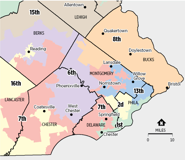
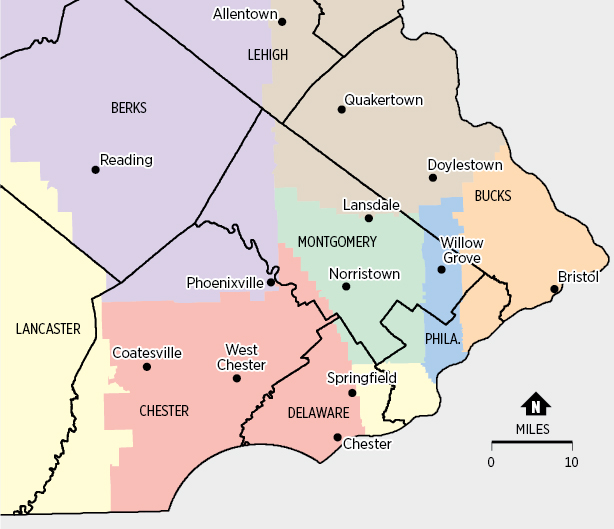
Found a suggested alternative from the Inquirer -
Pennsylvania’s congressional districts are among the most gerrymandered in the nation, according to experts. University of Michigan professor Jowei Chen created an alternative map that is more geographically compact, and drawn without regard to politics or race. The map below focuses on districts in Southeastern Pennsylvania.
Current -
Alternative -
http://www.philly.com/philly/infographics/280115652.html
DeminPennswoods
(15,286 posts)Looks to me as if it's completely drawn around Broad Street/Rt 611.
BumRushDaShow
(129,053 posts)straight up 611 which is part Broad Street and part Washington Lane/Old York Road up into Montco through Cheltenham and Jenkintown and Abington all the way up to Willow Grove. 
DeminPennswoods
(15,286 posts)From N Philly to the affluent burbs.
BumRushDaShow
(129,053 posts)maybe parts of Elkins Park but IMHO, "affluent" would be more in Delaware County along the Main Line, and you see the proposal for a district with Delco and Chesco together, where they kept Chester City & Coatesville in that proposed partition with Springfield and West Chester.
They have been steadily gentrifying North Philly (partly thanks to Temple taking much of it over).
DeminPennswoods
(15,286 posts)but of course not Main Line nice.
The colleges are scarfing up land left and right. I know not just N Philly around Temple, but Fishtown, Kensington and some of the other old ethnic neighborhoods were gentrifying, too. It's a conundrum because people who have lived in the same neighborhood for generations are being priced out.
BumRushDaShow
(129,053 posts)to shop mainly because there was a Strawbridge's & Wanamaker's there that was closer to us than the downtown stores.
All gone now but am still back and forth up there all the time!
You are right about the college expansion. Before Temple did their thing, I would say LaSalle was probably one of the first to start expanding in the Germantown/Olney area (back in the early '80s), then Penn & Drexel did their thing in West Philly, and then Temple FINALLY started doing something with all the houses they bought on and on either side of Broad St. back a few blocks, that they had left vacant for friggin 30 years. They started renovating the campus, built dorms, and built the Liacourus Center... And the most recent expansion has been St. Joe's University, that has completely transformed City Line Ave along West Philly and near Bala Cynwyd, from Bryn Mawr Ave. to Lancaster Ave. Pretty amazing!
And yes, this is all pricing people out due to the property tax hikes. 
DeminPennswoods
(15,286 posts)screwed up planned development. I lived in NE Philly, just south of NE airport. It was a wooded area when I first moved in, but as soon as that abatement started, developers bought all the land they could get and threw up flimsy houses everywhere at exorbinant prices. Really ruined the character of the area.
BumRushDaShow
(129,053 posts)I remember north of Street Rd up there was undeveloped. Now they have gone hog wild.
They bowled down the old Nabisco plant on Roosevelt Blvd. and are developing that land - http://mcbrealestate.com/demolition-former-nabisco-factory-commences-make-way-mixed-use-development-project/
The 10-year abatement also meant that any tiny piece of open land was jammed with some type of housing. Downtown near the river, all sorts of multistory, million dollar condos were built on top of tiny parking lots. Where I live, some properties were subdivided to throw housing in until neighbors complained to get the zoning updated. At some point before the housing crash, $39,000 "row" houses were suddenly called "townhomes" with a price tag of $399,000 (or more).  After the crash, the prices have come back down to earth.