Texas
Related: About this forumThe Flood Next Time - Trump plans to build his border wall in the Rio Grande flood plain
In July 2008, the U.S. Department of Justice shelled out $12,000 for a 1.71-acre strip of land along the Rio Grande’s north bank in the Texas border town of Roma. Designated RGC-1066, the property lay below a towering sandstone bluff offering a striking view of the Mexican city of Miguel Alemán. Sixty feet wide, the tract consisted of a short caliche road and a craggy riverbank overgrown with carrizo cane and mesquite. There, the Bush administration planned to build an 18-foot-high steel fence, part of roughly 700 miles of border wall that Congress had mandated. The wall, however, would never be in built in Roma, or anywhere else in Starr County: Federal engineers in both the U.S. and Mexican governments blocked the project, saying it would worsen flooding in an already flood-prone area. It was no idle speculation.
Over the course of three days in the summer of 2010, Hurricane Alex dumped more than two feet of rain on Northeast Mexico, overwhelming reservoirs and prompting dam releases along the Rio Grande. In Roma, floodwaters swallowed RGC-1066, climbing some 15 feet up the bluff. Had the fence been built, it would have been nearly submerged and might have washed away. When the floodwaters receded, much of RGC-1066 had simply vanished downstream. Elsewhere in the county, the same thing occurred: Land seized by the government was seized by the river. At a recent federal court hearing, a DOJ attorney put the matter thusly: “A lot of this land is not here anymore — so our take is someplace in the Gulf of Mexico.”
Today, despite the lesson imparted in 2010, the Trump administration has revived the dream of walling off flood-prone Starr County. In all, the administration hopes to run 63 miles of wall from Starr’s western edge into far-western Hidalgo County, downriver. Much of the barrier would slice through the Rio Grande floodplain. Trump also plans to super-size his wall, adding a 150-foot “enforcement zone,” a clear-cut corridor containing a Border Patrol road, electronic sensors, cameras and floodlights. (Customs and Border Protection has not addressed how that technology might fare underwater.) The plan means the government will soon seize new, wider swaths of property almost exactly where the river swallowed RGC-1066 nine years ago — a proposal that South Texas landowners and border-wall opponents view as reckless and absurd.
“They’re not being realistic, even with themselves, about the place they want to build these walls,” said Scott Nicol, a McAllen-based art professor, Sierra Club activist and member of the No Border Wall coalition. “And next time, instead of just soil and plants, you’ll have this 30-foot concrete-and-steel monstrosity washing down the river during a flood and threatening people downriver.”
Read more: https://www.texasobserver.org/the-flood-next-time/
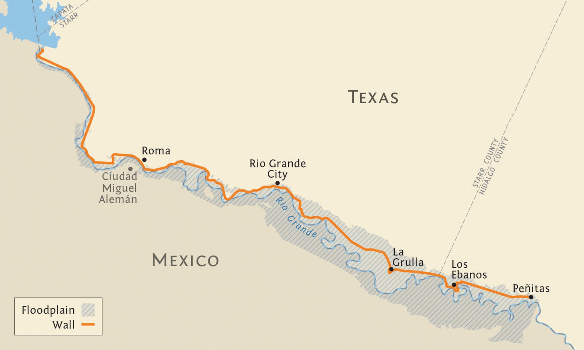
This 63-mile stretch of Trump’s proposed border wall slices in and out of the Rio Grande floodplain between Starr County’s western edge and the tiny town of Peñitas, where a system of flood levees begins. (Note: The actual wall would have small gaps for ports of entry and certain creeks, not represented here.) DOLLY HOLMES
 = new reply since forum marked as read
Highlight:
NoneDon't highlight anything
5 newestHighlight 5 most recent replies
= new reply since forum marked as read
Highlight:
NoneDon't highlight anything
5 newestHighlight 5 most recent replies

Delmette2.0
(4,164 posts)He just wants a wall, any wall built anywhere so he can say It's done.
