NASA - "What We Are Witnessing Is Major Hydrologic Change"; 14 Years Of Data Show Growing Extremes
NASA Earth Observatory reported this week (May 23, 2018) on a new, first-of-its-kind study, combining 14 years of satellite observations with data on human activities, showing where and how freshwater is changing on Earth. When we say freshwater, we’re speaking of the water found in lakes, rivers, soil, snow, groundwater and ice. The peer-reviewed journal Nature published the study on May 16. Hydrologist Jay Famiglietti of NASA’s Jet Propulsion Laboratory, a study co-author, summed up the results when he said:
What we are witnessing is major hydrologic change. We see a distinctive pattern of the wet land areas of the world getting wetter—those are the high latitudes and the tropics—and the dry areas in between getting drier. Embedded within the dry areas, we see multiple hot spots resulting from groundwater depletion.
The study authors attribute the changes to a variety of factors, including water management, climate change, and natural cycles.
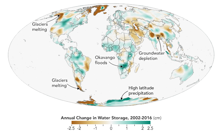 This map above depicts changes in water storage on Earth – on the surface, underground, and locked in ice and snow – between 2002 and 2016. Shades of green represent areas where freshwater levels have increased, while browns depict areas where they have been depleted. Image via NASA Earth Observatory.
The research team analyzed 14 years of observations from the Gravity Recovery and Climate Experiment (GRACE) satellite to track trends in freshwater in 34 regions around the world. To put those trends in context, the scientists correlated GRACE findings with precipitation data from the Global Precipitation Climatology Project; with land cover imagery and data from Landsat; with irrigation maps; and with published reports of human activities in agriculture, mining, and reservoir operations.
EDIT
http://earthsky.org/earth/satellites-map-14-years-global-freshwater-change
 = new reply since forum marked as read
