Environment & Energy
Related: About this forumGerman satellite on 'berg watch' (Pine Island Glacier)
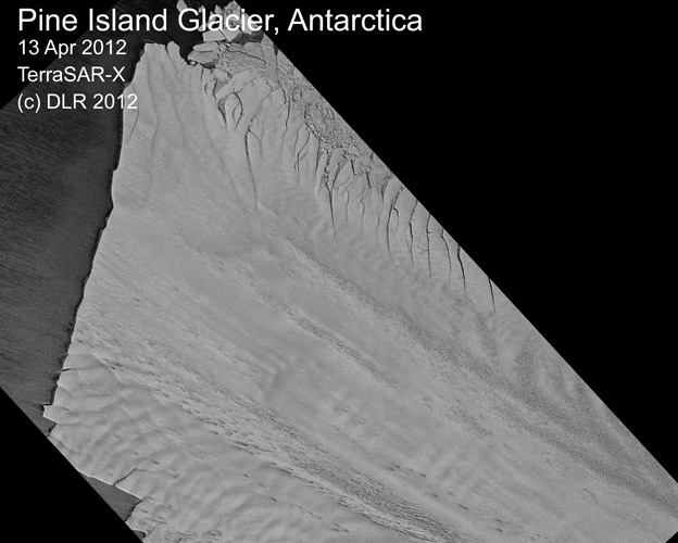
The German radar satellite TerraSAR-X is on "PIG watch".The spacecraft, which circles the globe at an altitude of 500km, is returning regular images of the Pine Island Glacier (PIG) ice shelf.
Scientists expect its observations to alert them to the birth of a monster iceberg covering some 750 sq km.
A huge crack in the shelf was first noticed in TerraSAR-X data back on 13 October. A Nasa aeroplane also got photographic confirmation the next day.
The crack seems to have propagated in two main steps - the first break tearing a 24km-long gash in the shelf; the second, just a few days later, opening up the fracture to 28km in length.
A few more km and the tabular block of ice will be floating free of the shelf.

More: http://www.bbc.co.uk/news/science-environment-17835476
 = new reply since forum marked as read
Highlight:
NoneDon't highlight anything
5 newestHighlight 5 most recent replies
= new reply since forum marked as read
Highlight:
NoneDon't highlight anything
5 newestHighlight 5 most recent replies

hatrack
(59,585 posts)Oh.
Never mind! 

Dead_Parrot
(14,478 posts)Does anyone know where I can get a 30-mile-wide glass and 1.6 quadrillion gallons of scotch?

FirstLight
(13,360 posts)DUzy! 
FirstLight
(13,360 posts)The area is how big?
This map/dotted line is very confusing at the BBC site
http://www.bbc.co.uk/news/science-environment-17835476
and when I pulled up a map, it looks like a third of the fucking CONTINENT is breaking off!

 this is HUGE news...where's the MSM? oh yeah, sorry...climate chg is a farce, riiiight...
Can I ask a stupid question? ...what is the result if THAT MUCH freshwater is released into the ocean?
Dead_Parrot
(14,478 posts)The dotted line on the BBC map is just showing you where the Tansantartic Mountains split the continent into two: A bit like getting a map of the US and drawing a line through the Rockies. In the image you posted, they're the grey bit just down from the pole (but they do look a bit crack-ish in that one).
Here's a map that shows the area a little better: You can see the tip of S. America & Falkland Islands for scale.

edit: The problem is that PIG holds back the rest of the ice - and if it all goes, it could get "interesting".
FirstLight
(13,360 posts)phew!
But ya, still not looking very good...and they way all the models say "in the next 100 years" and then something happens within MONTHS...that's not cool either!
FirstLight
(13,360 posts)But it still doesn't make me feel much better about this...


GliderGuider
(21,088 posts)This is precisely why they invented Photoshop.
Problem:

No Problem:
Anything else I can fix for you Nervous Nellies while I'm at it?
hatrack
(59,585 posts)
Thanks, I needed that!