Environment & Energy
Related: About this forumLooks like Northwest Passage is almost open...probably within a week.

Northeast across the top of Russia is still closed for now.
On Edit...I just noticed all that ice in the Great Lakes...lol. Where's that data coming from?
 = new reply since forum marked as read
Highlight:
NoneDon't highlight anything
5 newestHighlight 5 most recent replies
= new reply since forum marked as read
Highlight:
NoneDon't highlight anything
5 newestHighlight 5 most recent replies

Control-Z
(15,682 posts)but has it ever been open before? Or, when was the last time?
OnlinePoker
(5,719 posts)Then in the last 5 or so years, it has opened every year. This is the earliest I can recall seeing it open. Last year, for example, it fully opened around the 14th of August.

greyl
(22,990 posts)(Originally published 8/26/07) European kings, queens, merchants, and adventurers have sought a sea passage from the Atlantic to the Pacific oceans since the 1500s.
Their quest was to promote commerce. Ferdinand Magellan found a channel across the bottom of South America in 1520. But it is a long, difficult route from Europe to Asia. So the search has gone on for a way "over the top," namely, across the frozen north above Canada.
For four centuries dozens of expeditions, land and sea, were mounted to find the fabled "Northwest Passage." Many men died in the attempts, and the stories of ships stranded above the Artic Circle in the cold and ice--some forever--are dramatic. Finally, in 1905, Roald Amundsen of Norway completed the trip in a small boat. But his complicated passage has never proven to have commercial possibilities.
Global Warming, at least the melting of the polar cap, may change the picture in years to come. An August 22, 2007 picture by NASA of the region (see above) indicates that the sea ice is retreating to the point where a commercial sea connection between Europe and Asia may become a reality. In the image, blue is open water; white indicates heavy sea ice concentration; and turquoise shows loosely packed sea ice. The Atlantic is on the bottom of the image; the Pacific on top. The small black circle in the center indicates the North Pole. A "nearly open" passage is evident from the Atlantic to the Pacific on the left of the Pole toward North America.
More
And from 2011:
Staggering Arctic map shows how impassable Northwest Passage is opening up as polar ice caps melt
This staggering image shows how cracks in the ice big enough for ships to sail through have appeared across the Arctic.
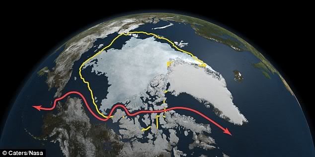
The near-record summer ice melt in the region has seen shipping channels of the Northwest Passage carved open.
And scientific climate predictions have suggested that the Arctic could lose almost all of its summer ice cover by 2100 - forcing polar bears to swim more than they walk.
On September 9 the ice covering reached its lowest point this year with 1.67million square miles of snow and ice - down by 110,000sq miles on the average for September.
[link:http://www.dailymail.co.uk/news/article-2045708/Staggering-Arctic-map-shows-impassable-Northwest-Passage-opening-polar-ice-caps-melt.html|
More]

longship
(40,416 posts)How else are we going to keep our beer cold? Sheesh!


hatrack
(59,585 posts)Some minor ice issues approaching the Bering from the west, but that's about it.
OnlinePoker
(5,719 posts)But the images show hundreds of kilometres of Chukotka coastline still have ice on it so I can't see how it can be traversed without the use of an icebreaker. When I say open, I mean fully traversible without aid. When shipping companies start to see this happening every year, you know they will start scheduling runs through the arctic to save money, with the inevitable consequence of environmental destruction that will follow.