The report mentioned "Boiling water", that can only be caused by a Volcano. Antarctica has several volcano and one theory for the existence of under ice lakes of water is that the water is kept warm by volcano action (i.e. enough heat is provided via some volcano to keep the lake from freezing). Please note it is possible for the lake to never have frozen in the first place, just iced over, but just pointing out the volcano theory and that the Volcano is the best explanation for any boiling water reported in Antarctica.
On the other hand, the vast majority of the heat is being provided by the ocean. The Southern Ocean is a circular rotation of currents that keeps most of Antarctic isolated from the heat in the Indian, Pacific and Atlantic oceans. On a map the Southern Ocean looks like just that part of those three oceans next to Antarctica, but do to the circular rotation of the currents around Antarctica that is NOT the case. The Southern Ocean acts as a barrier to movement of water from those three oceans to the coasts of Antarctica.
The problem with the Southern Ocean is that it is directly connected to the Indian, Pacific and Atlantic Oceans, Thus some heat does get exchanged between those three oceans and the Southern Ocean AND thus Antarctica. Worse the Southern Ocean is at its weakest south of South America, where heat from the Pacific and the Atlantic can get close to Antarctica AND cold water can escape (El Nino is an example of such a movement of Cold water from the Southern Ocean to the Pacific, which also means warmer water from elsewhere entered the Southern Ocean, warming up the Southern Ocean).
A further problem is the West Antarctic Ice Sheet (WAIS) is directly south of South America. Drake Straits is the Closest Antarctica gets to another Continent. Drake Straits is ocean deep, but shadow compared to the rest of the Southern Ocean (In fact do to the Narrowest and shadowiest of Drake Strait, the "Ocean Conveyor belt, goes from the Caribbean Sea to Iceland, where it loses its heat, but retains its salt, then flows south, joined in from cold water from the Mediterranean, then flows south to the Southern Ocean, then east through the Indian ocean to the Pacific, where the salt is lost and the water rises and return as a surface current to the Caribbean).
More on the Ocean Conveyor belt:
http://oceanservice.noaa.gov/facts/conveyor.html
http://oceanmotion.org/html/background/ocean-conveyor-belt.htm
http://www.enviroliteracy.org/article.php/545.html
http://www.sciencedaily.com/releases/2010/06/100618102646.htm
Please note it takes about 1000 years for water to go through this system, but it tends to keep most of the world at the same temperature.
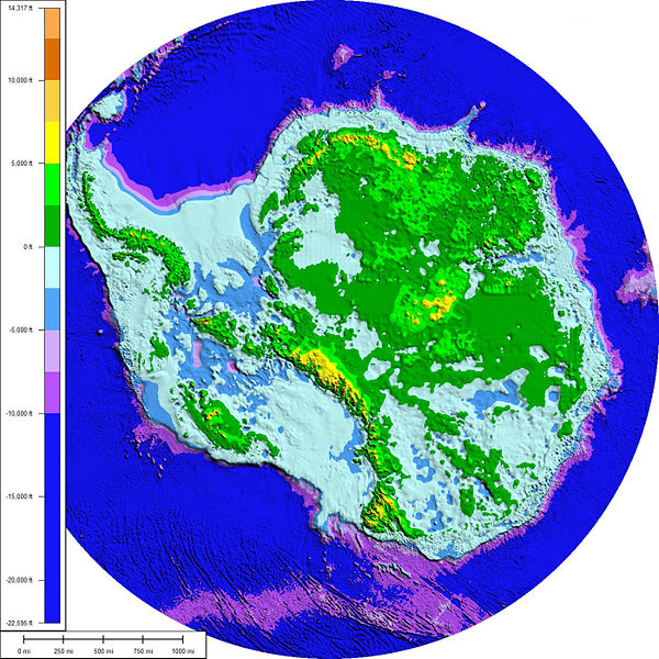
You also have to understand that West Antarctic is NOT one piece of land but a series of interconnected islands, connected by the West Antarctic Ice Sheet (WAIS). Here is a map of Antarctica without ice, notice on the Left, which is West Antarctica mostly islands:
http://en.wikipedia.org/wiki/Antarctica
More maps of Antarctica:
http://commons.wikimedia.org/wiki/Atlas_of_Antarctica
More on the West Antarctic Ice Sheet:
http://en.wikipedia.org/wiki/West_Antarctic_Ice_Sheet
http://earthsky.org/earth/sophie-nowicki-on-weak-underbelly-of-west-antarctic-ice-sheet
http://www.sciencedaily.com/releases/2010/01/100116103350.htm
http://thinkprogress.org/climate/2009/02/05/203656/antarctic-ice-sheet-collapse-even-more-catastrophic-for-us-coasts/
http://science.nasa.gov/science-news/science-at-nasa/2000/ast27dec_1/
More on the Antarctic Circumpolar Current:
http://en.wikipedia.org/wiki/Antarctic_Circumpolar_Current
http://phys.org/news191483678.html
http://www.antarctica.gov.au/about-us/publications/australian-antarctic-magazine/2001-2005/issue-4-spring-2002/the-southern-oceans-global-reach
El Nino tied in with the Antarctic Circumpolar Current:
http://www.spacedaily.com/news/pacific-01b.html
 = new reply since forum marked as read